Two weather apps on my phone one came pre installed it says the winds in my area tomorrow will be about 15-18 kph, the other one installed by me says the winds will be upto 70-80mph.
We'll see. I expect there will be renewed efforts to uninstall the pre installed app on Saturday.
Great! I'm supposed to be flying to Dublin tomorrow. I hope they cancel the flights early enough so I'm not in limbo at the airport.
ChuckMorrisFree Member
Great! I’m supposed to be flying to Dublin tomorrow. I hope they cancel the flights early enough so I’m not in limbo at the airport.
Dublin Airport Authority meeting with the airlines right now I think, to discuss what's what. There'll definitely be nothing flying in or out in the morning - just a case of whether the airline makes it 'official' in time for you.
A family member who lives on the Ayrshire coast shared their bbc weather forecast, showing 80-90mph gusts tomorrow. That's proper batten down the hatches territory, and is going to cause damage and disruption...
I was in Faindourain the night Bawbag went through. That was an interesting experience. Next morning:
You became a skilled charcoal artist?
Dublin Airport Authority meeting with the airlines right now I think, to discuss what’s what. There’ll definitely be nothing flying in or out in the morning – just a case of whether the airline makes it ‘official’ in time for you.
Going to be a whole load of cancelled / disrupted / diverted flights from tomorrow and then over the weekend as they try to get planes and crew back to where they should be...
flights
And trains, buses, truck deliveries etc.
Isle of Man Government run its own separate weather forecasting service, it is not part of UK Met Office but as is the way of these things data and information flows backwards and forwards between the two. IoM Met Office issues official weather warnings for Isle of Man, and UK Met Office doesn't. Similar arrangements exist in the Channel Islands re States of Jersey and Guernsey.
The IoM Met Office do have their own Red warning in place for the Isle of Man tomorrow, and a little bit of effort by the BBC presenter would have uncovered that, but many of the aspects and intricacies of the diverse nature of governance across the UK and its various territories and dependancies seem quite opaque to UK wide broadcasters
it’s a change in communication mainly (though these are becoming more common events). Started in maybe 2014/15 or so IIRC. A lot of the old named storms were named by the US and we dealt with the remnants of them referring to the same name.
Erm...
Storms are named now as a public safety campaign to increase awareness - it stops people like Derek driving his high-sided truck over the A66 thus endangering all other motorists and the emergency services who will inevitably have to rescue him when he gets blown over by a 80mph gust.
They get named based upon the impact of the storm on the affected location.
look at the FAQ here: https://www.metoffice.gov.uk/weather/warnings-and-advice/uk-storm-centre/index
The frequency and severity of storms has not radically changed in recent years, there has been some subtle increases though. We are fortunate in that the majority of these powerful storm systems tend to veer northward and thus do not affect highly populated areas. A big storm smashing Shetland and northern Norway is not as newsworthy as a medium sized storm hitting London or Rotterdam.
Also these events are not usually tired tropical cyclones (TC) that transition into extra-tropical cyclones (ETC) although that can and does happen (ex-Hurricane Leslie smashed into Portugal in 2018). The peak Hurricane season in the Atlantic is May to November whereas these ETCs tend to be a winter phenomena with peak season Oct to Mar. These ETCs can happen at any time of the year if the conditions are right.
The various Red warnings issued by different Met agencies are done to different sets of criteria, and that means that in a very similar weather situation then there can be differences in the warnings in force between the various agencies, even if they are forecasting similar weather.
AIUI Met Eirann issue Red warnings if wind is likely to gust above 130km per hour, - a simple threshold - whereas UK Met Office try and provide a more complex and subjective risk assessment of whether or not the winds are highly likely to have a high impact on the population and services in the affected area - so there is no set threshold number with the UK Met Office that automatically triggers a Red warning. This can mean that Red warnings can end up being issued at different wind speed values for different storms in the UK depending on where and when the storm occurs. 12 hrs of 75mph winds in Birmingham or Manchester in daytime would probably be more likely to produce severe strain on some aspects of society than eg 3 hrs of 85mph winds in ...say for the sake of argument Shetland. Thats not to say Shetland wouldn't see problems, of course it would, but there are things like the familiarity of the population with windy weather and the lack of tree cover that mean things may not be as acute there, and an Amber warning may be more appropriate in some circumstances.
Red warnings shut things down, and need to be used carefully and sparingly and simplistic wind speed threshold can work against that
Hmm, weather is fairly benign on Monday when I planned to ride every little bit of sketchy low down singletrack around Dunblane and Stirling, am thinking there could be a few trees down though! Maybe head east to Dundee and enjoy a bit of a tailwind back instead...
We're in the Strathearn windtunnel between Stirling and Perth, and we're basically at the highest point, could be interesting to hear it whistling past!
The use of a simplistic parametric trigger is a bit siily and the UKMO system is probably better thought out in that regard. Where will the 130km/h occur? on a lighthouse 10km off land? On a hill? At Dublin airport? At my auntie's house in Co. Carlow? Also, the damage to buildings and infrastructure at 129km/h is identical to 130km/h.
In many ways it's good that we have these warning systems now. When the "Great Storm of 1987", or "87J", arrived the prediction models were still in their infancy. With the increase in computing power, satellites and other instrumentation we are in a much more informed position now and thus can provide these warnings (to those that will listen)
We’re in the Strathearn windtunnel between Stirling and Perth, and we’re basically at the highest point, could be interesting to hear it whistling past!
I will lob a tennis ball into the maelstrom from our house and you can catch it a few minutes / 14 miles later.
And yes, Darn path etc will be battered I suspect...
@ElShalimo - I didn't word it very well (skiving at work), but that's more or less exactly what I was trying to say.
Red warnings shut things down, and need to be used carefully and sparingly and simplistic wind speed threshold can work against that
Possibly the complaints (about too many named weather events) arise because so much of our weather is now given an alert of some kind which people then gossip about more than they normally would, and because of the way in which those alerts are used. I've seen a few cancellations of events, and closures, because of yellow weather warnings in the few months - one was a craft market which takes place once a month near the city centre (can't remember whether this was wind or rain or both), and two were closures of all outdoor areas at WWT Llanelli, a wetland nature reserve. (both for wind) I was at the reserve for both these closures and was quite surprised to get back to the visitor centre to find notices up blocking the exits. They were windy autumn/winter days, I hadn't been risking my life out in extreme weather.
They do cancel craft fairs and markets etc for yellow warnings not because people may die but because those craft stalls are not really suitable for use in high wind and there'll be tarps, cupcakes, wooden letters and homemade candles blowing all over the place. I've seen stallholders pack up and go before in moderate winds so it makes sense to cancel it so people don't turn up and have to go home again.
Two weather apps on my phone one came pre installed it says the winds in my area tomorrow will be about 15-18 kph, the other one installed by me says the winds will be upto 70-80mph.
Nearly all weather apps buy generic global weather data mostly from US forecasters. This is low resolution and doesn't take into account local features - because it covers the whole world. You should use the Met Office because they're the people who've been specialising in UK weather for a really long time and are about as good as it's possible to get. But use your brain - they give a percentage chance of rain during any given hour, so if you get 20% numbers all day there may not be a raindrop symbol but the chance of rain at some point during the day is quite high.
Also worth noting that 20% rain is not a 20% chance of rain. It’s a forecast that there will be rain in 20% of the forecast area.
Cancelling events etc is often about the inability of the general public to behave responsibly and having to deal with the fallout of cancelling mid-event. Also you can't get sued by someone getting hurt doing something silly if you cancel the event.
The self-entitlement on display is often hilarious. "An asteroid is about to hit us yet they want to cancel our wedding reception to use the village hall as an emergency shelter...don't they know how that will make me feel. Boo hoo "
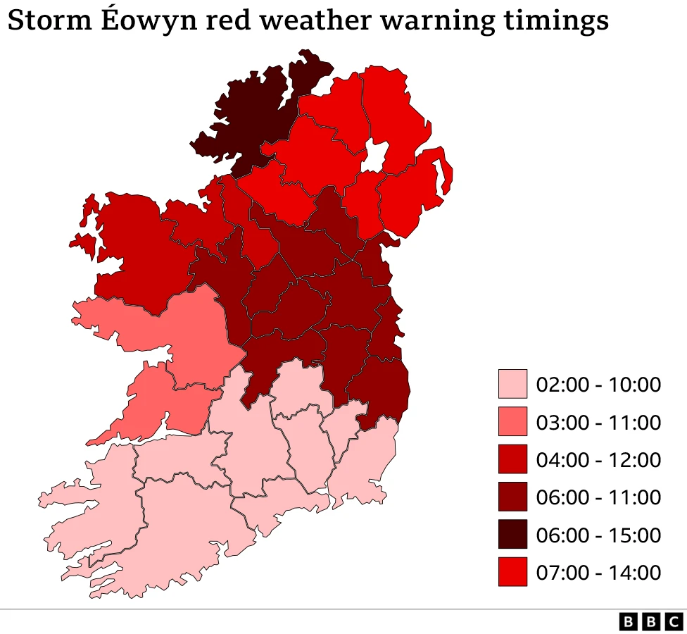
as you can see the storm stops at the border
yesterday the warnings map showed the Republic as red and all of NI as 'orange'!
now it looks like we're all in it together, red all over:
Also worth noting that 20% rain is not a 20% chance of rain. It’s a forecast that there will be rain in 20% of the forecast area.
only if your source of reference is tiktok
Met office* have confirmed both on their website - and their social media that 20% chance of rain would be a 2/10 chance of rain nothing to do with a forecast area.
*other agencies may differ
Link to Met Office "What does this forecast mean?" page which explains the components of the forecast. Here's the precip explation verbatim:
Chance of precipitation
For example, a 70% chance means a 7 in 10 chance that precipitation will fall at some point during that period.Precipitation means falling water (rain, sleet, snow, hail or drizzle).
We show the chance that at least 0.1mm of precipitation will fall within 1 hour, on the hourly forecast. Or 0.3mm within 3 hours on the 3 hourly forecast. This precipitation may fall across the whole time or fall in a short sharp burst. The weather symbol can help show the difference between light and heavy precipitation.
With respect to weather apps and resolution MO data is 1.5km (deterministic) and 2km (ensemble) over the UK compared to most global forecasts being ~10km (ECMWF, main supplier of medium range forecasts over Europe is 9km deterministic and ensemble).
Cancelling events etc is often about the inability of the general public to behave responsibly and having to deal with the fallout of cancelling mid-event. Also you can’t get sued by someone getting hurt doing something silly if you cancel the event.
Or a complete inability to grasp that events dont spring up instantly such as when the NYE stuff in Edinburgh got cancelled and lots of smooth brains were ranting that the weather wasn't actually that bad on NYE, but completely fail to understand that the infrastructure required for the event wouldn't just suddenly appear on NYE, because fairies, and in fact would have to be built in the days preceding that, and it wasn't a great idea to try and build stages and electrical stuff in the middle of gale force winds and torrential rain
I stand corrected, thanks. I got that notion somewhere obviously but clearly never bothered to check it myself…I always look at the radar for an indication of whether or not it will rain and I don’t pay attention to the percentages which is probably why I never thought about checking my understanding of them.
I think the comms on it wasn't great until the past couple of years. There's a nice paper about how the public do (or don't...) understand probabilities used in forecasts for the (very!) interested reader.
Aaaaaand that's the schools closed tomorrow in Perth and Kinross 😥
Wife will be furious, she's off Fridays. Will need to fabricate some sort of work crisis so I can shut myself away in my office and avoid the carnage of a bored house-bound 7 year old (and bored house-bound cat, who will probably be hiding with me) 😆
Seems all of Stirling council services closed - and I have text from doctors to say emergencies only, no hospital or care home visitors tomorrow etc.
I have text from doctors to say emergencies only, no hospital or care home visitors tomorrow etc.
That's sensible given the forecast.
A 50 mph wind will knock Morag over in the car park and the 75mph gusts will pin her there until Tuesday
The system is probably going to come in slightly further north than the earlier forecasts but it's still going to be very disruptive at best.
@13thfloor - same, I have every other Friday off and a) The weather is always shite and b)whenever the schools shut it’s a Friday.
My children’s school is only half shut so one is in and one not FFs
Having grown up on the Ayrshire coast, I normally think these things are a bit over-hyped but err....

Bloody hell, 100mph gusts and a central pressure of under 950mB
Last time I went out on foot near the house to see how an 80mph gust felt I lost my glasses...blown clean off and never seen again! A painstaking search to find them on a calmer day ,as I had seen their trajectory but never found. An expensive mistake that.
I had emerged from a sheltered leeward spot, decided to go back pretty much straight away and it that split second they flew off.....
Ooh the phone alarm thing is good though. BLLAAARARRGH BLLLARRRGH
Yep, had ours too.
Meeeeeep meeeeep meeeeeeeeeep.
Ooh the phone alarm thing is good though. BLLAAARARRGH BLLLARRRGH
😆
I'm sat on a busy train as it came through, what a racket!
I got such a fright I instinctively bashed the back button and lost it, didn't get a chance to read message 🙄
Both my mobiles (no, not a dealer - personal and work) received the UK Emergency Alert 10 mins ago. First time I've ever received those - 'kin hell, they're loud and irritating! Which I know is the point...
I was bungee cording the wheely bins. Almost had an eye out when i jumped.
To be honest such is my lack of faith in our political betters these days I don't really want them able to override my phone like that, who knows what cockwittery they've infected it with... 🙄
All schools in Angus closed tomorrow. The lad is happy as he had a higher prelim tomorrow, so has a day of reprieve,and probably a day gaming.
I cancelled the mobile alerts back when we were first told about them for the trail run.
The system is probably going to come in slightly further north than the earlier forecasts but it’s still going to be very disruptive at best.
Where are you tracking it? For the purely selfish reasons of trying to decide where to ride on Monday (i.e. where might be least affected by windfall...)
The use of a simplistic parametric trigger is a bit siily and the UKMO system is probably better thought out in that regard. Where will the 130km/h occur? on a lighthouse 10km off land? On a hill? At Dublin airport? At my auntie’s house in Co. Carlow? Also, the damage to buildings and infrastructure at 129km/h is identical to 130km/h.
Met Éireann issues weather warnings on a county-by-county basis afaik. If there's a red warning for wind in Carlow it's because the forecasted wind in Carlow is above their threshold, not because it's going to be absolutely howling in Belmullet or wherever.
It's still daft as there's no such thing as an average windspeed per county and if it's a large county coastal gusts can be 2-3x the gust inland
