Just found this on google earth, not a million miles away from a popular riding destination, but not one I've heard of other people riding (starts at about 800m, descends for about 3k). That'll be my next camping trip sorted then!
[IMG]  [/IMG]
Anyone found anything else tasty looking?
had a version of this on my desktop for a while - very visible despite being only about 2-4 ft wide
(It's in the US though)
[url= http://farm6.static.flickr.com/5127/5243568855_b2af999817.jp g" target="_blank">
[url= http://www.flickr.com/photos/23823661@N05/5243568855/ ]sanjuan satellite[/url] by [url= http://www.flickr.com/people/23823661@N05/ ]scaredypants[/url], on Flickr
Nice! Almost looks like the Stelvio pass, but dirt..
And now to scroll across all of Scotland untill I find that top trail...
13thFM - another clue please
This is down for investigation next summer: [img] 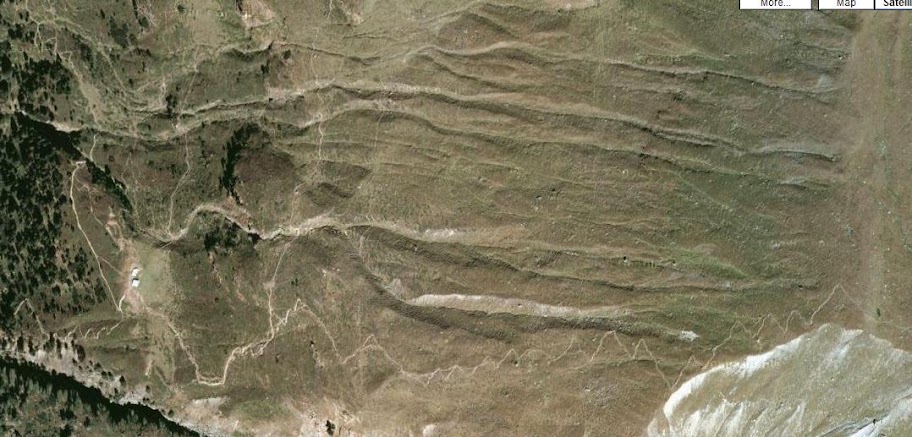 [/img]
It is in Austria though so not sure if that is enough for trades? I fear all the Scottish ones you will already know of 13thfloor
I'm hesitant to give the location of the first one away, I want to be the first to ride it! (or at least, the first to ride it then boast about it on here). I'll stick with 'near the falls of glomach' for now.
already know of 13thfloor
Well, I do like geeking over my maps and my google earth, nothing to be too proud of though! 😀
Having just lost an hour to geograph I think some time spent in Kintail is needed next summer. I reckon if any of these trails turn out good I will have to get Mr Webb a pint
Haha, I've decided that 'Mr Webb' is in fact Legion, no-one could possibly have photographed EVERY SINGLE BOG in Scotland, yet he appears to have...
DavidM, not sure if you found it or not, but Kintail is definitely the right region. I'm plotting away already, will post in advance if I'm headed that way.
Try NH0020 that looks a good run
The man takes a good photo of endless bog. Is there a euro geograph yet?
Haven't found that trail yet but there look to be a lot of trails round that way. Looks ripe for pushing up and riding back down. I imagine it could be under a bit of snow for a while yet though?
Flatfish, good shout, that trails a bit of an established classic apparently, although I flunked my opportunity to ride it when I was there. Looks to have some intriguing possibilities involving the nearby munro...
[IMG]  [/IMG]
13FM,
My initial thought was this tasty-looking set of zag-zigs, but I don't think they're the same.
[url= http://farm6.static.flickr.com/5241/5244084033_f84e716498_z.jp g" target="_blank">
[url= http://www.flickr.com/photos/stuartie_c/5244084033/ ]zigzags[/url] by [url= http://www.flickr.com/people/stuartie_c/ ]stuartie_c[/url], on Flickr
Like you, I want to be first down them on a bike... 😀
Hmm... staring at them endlessly isn't giving me any clues, I'll need to do some detective work to figure out where those are Stuartie!
[url= http://maps.google.co.uk/maps?q=strathcarron&ie=UTF8&hl=en&hq=&hnear=Strathcarron,+Highland,+United+Kingdom&ll=57.476793,-5.232947&spn=0.005059,0.015053&t=h&z=17 ]Ahem[/url]
OS says one end of that is at 900m and the other is near enough sea level. Hhhmmm. Still can't find stuartie's trail though
EDIT. I have rather given the location away there