There's been a few suggestions on the last thread, but I want to go with one of my earlier ideas.
The theme for next weekend will be [b]measuring and marking the land[/b].
If that's too cryptic, just stick with [b][url= http://en.wikipedia.org/wiki/Retriangulation_of_Great_Britain ]trig points[/url][/b].
If you want to try to find something a bit different though, well, there's milestones and mileposts for a start and the less common boundary stones, all marked on OS maps.
There's also various dykes and walls marking the boundaries of ancient kingdoms and empires.
There's summit markers on hills and flood depth markers in valleys.
Anything similar with historical importance or interest will do.
How do people feel about making this a week long challenge from now on, rather than just a weekend ?
Some people work shifts or have other commitments at weekends, so they might find it easier to get out during the week. There will be a lot more midweek evening rides going on once the weather warms up and the days get longer too.
Shall we start this one at midnight tonight then, so it's Monday to Sunday ? Or would Saturday to Friday be better ? Or just stick to weekends, it's not like I'm too bothered if people post on the wrong day.
i have been doing this for the last 15 years or so
http://www.ctc.org.uk/DesktopDefault.aspx?TabID=3889
still got well over half of it to do.
some might be interested
That BCQ thing looks fun, it's a bit like a trailquest. 😉
I thought they'd have had more entrants for a cyclists [i]touring[/i] club though. It looks like you only need to visit six to get on the leader board.
all-week challenge suits me as i often find myself working weekends 🙂
Are there any sites I can search to find local trig points?
Google?
Googling didn't really help much.
ooh, plans are afoot 🙂
Googling didn't really help much.
[url= http://lmgtfy.com/?q=trig+points+in+the+uk ]Try here then[/url]
Fantastic theme. Got some ideas here!
I didn't previously know, but it doesn't surprise me to find out, that there is a "trigpointing community" and a trigpointing website with a search function.
http://www.trigpointinguk.com/index.php
Edit;
Just had a bit of a look round that site and there's 20 trig points within 8.7km of home. This is too easy. 😛
Such a good idea this! Time to Suss out a plan.. I reckon week long challenges are a good plan.
Cheers MTG, looks like I have a few to try out!
Interesting. I have a few things in ind already...
Could I give a suggestion for the week after? There was a little of this cropping up in this weekends photos. Hows about Public art - good, bad or self-made if you can't find it. I'd be very keen to see what people have around their parts of the countryside. I imagine a high count of Gormleys.
I'd prefer a weeklong challenge as I don't get to ride weekends.. 🙂
Public art is a good'un. I have a feeling I'll only be able to find crappy skatepark graffiti though 😆
OK then, public art next week, but no jumping the gun. We've got a week of trig points first and that doesn't start until midnight tonight.
Oooh, I love graffiti pics. May pass on the trig point one - no way am I dragging my BMX to the top of Twm Barlwm 😉 😆
Quick genuine question - I know of some trig points close to me, but they may be on farmers land, but not near a BW - are there any laws about public access to trig points?
I can only guess that it is similar to having a telegraph pole or electricity pylon on private land and there is some sort of contract between the Ordnance Survey and the land owner to allow the OS access to their trig point.
As there is no [i]need[/i] to allow public access to trig points, I can't see why there would be a law to treat them differently to any other private property on private land.
Ooh, I own one! Not a whole Trig point but it's urban little brother a Bench Mark! Will there be hordes of STWers parading into the front garden upsetting my tenant I wonder?
Fair point Dawson, as per Graham there quite a few around me but a few are no where near a public right of way.
What's more worrying is that I been cycling by TP6417 for ages (all around it!) and never knew one was there! (marked as still being there on that TP site)
All week is good. From Monday to Sunday.
Trigtastic............. 😉
a sneaky one trying to hide in a school grounds
[IMG]  [/IMG]
but i sussed it out.
[IMG]  [/IMG]
and one on a very busy fast lane.
[IMG]  [/IMG]
the rhubard triangle is also the trig point triangle........ 8)
Bah. Beaten to being first. I'm still eding and uploading.
I suggested that one 😡 😉
I've got an OS benchmark on my house 🙂
Taken before dawn this morning, flood depth marker alongside the Severn in Bewdley.
[url= http://farm6.static.flickr.com/5215/5384910803_629e69569d.jp g" target="_blank">
[url= http://www.flickr.com/photos/8805115@N04/5384910803/ ]Picture 032[/url] by [url= http://www.flickr.com/people/8805115@N04/ ]Vegan Graham[/url], on Flickr
Site keeps falling down tonight so it's taking me ages to post.
Anyway, on a similar theme to MTG:
The plaque marking the 1953 and 1978 floods at Wells-next-the-Sea.
[IMG]  [/IMG]
[IMG]  [/IMG]
The plaque has been put up in a very silly place. The wall it's on is part of a sea defence constructed after the last major flood of 1978 but it's on the opposite side to the quayside and the view. It should have been on the Tide Recorder Station(flood level is about at the beam above the bike):
[IMG]  [/IMG]
This is going to be my take on the theme this week. Hopefully different places on the coast at the same time each day marking:
Bike at tide level at the time (here it was fully out - low tide)
[IMG]  [/IMG]
And at mark of previous high tide.
[IMG]  [/IMG]
Didn't go as intended yesterday.
High tide mark down there:
[IMG]  [/IMG]
Low tide mark about 3/4 mike back there:
[IMG]  [/IMG]
Pig at a Trig on Lotus Hill near Mabie
[IMG] 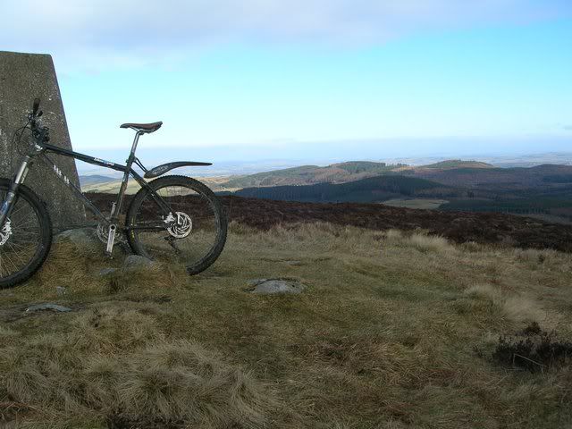 [/IMG]
[IMG] 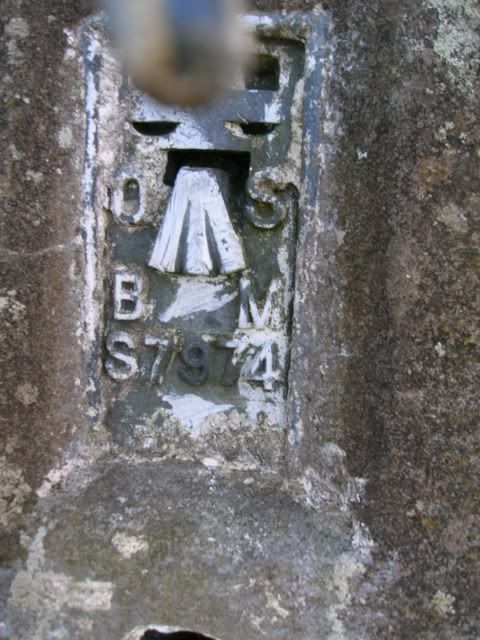 [/IMG]
Ae and Dalswinton wind farm in the distance
[IMG]  [/IMG]
Had planned to do 2 more but not enough time 🙄
[img] 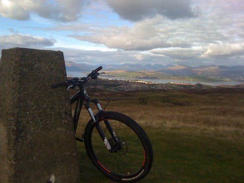 [/img]
Dunrod Hill Greenock
[img]  [/img]
Kunstler - glad to see your bike managed to stay dry this week!
I've been lucky. You'd think I'd learn and not be stupid enough to keep photographing it right next to the sea.
Had a spin out yesterday - 6 miles out and everything to my left was reclaimed from the sea for the length of the ride. Stopped at some big dunes which the MOD had marked by blowing bloody great craters in the them (years ago, they weren't still smouldering). Camera couldn't cope with the low light (got there too late) and wind was cutting so I didn't hang about. Maybe another pic tomorrow. It was looks nicer when the tide is in.
What boundary ?
[img]  [/img]
😉
[img]  [/img]
Neolithic Boundary
[img]  [/img]
[img]  [/img]
[img]  [/img]
[img]  [/img]
[img]  [/img]
Needs to be seen bigger for wording...
http://www.zooomr.com/z/photos/zoom/9757598/size-32/
As per Graham, I'm surrounded by Trig Points, of these I was only aware of two. Managed what would be something like a 45mile loop to get them all (I actually went home after Wimbury and finished it earlier today). Lots more tarmac work than I'm used to but a bit of fun that got me out for a couple more rides than normal.
Gothersley TP3420
[img] 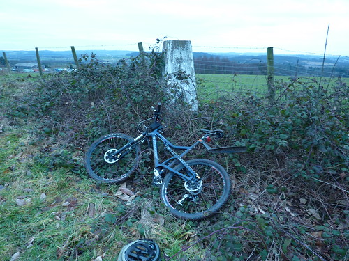 [/img]
Chase Pool Lodge TP2129
[img] 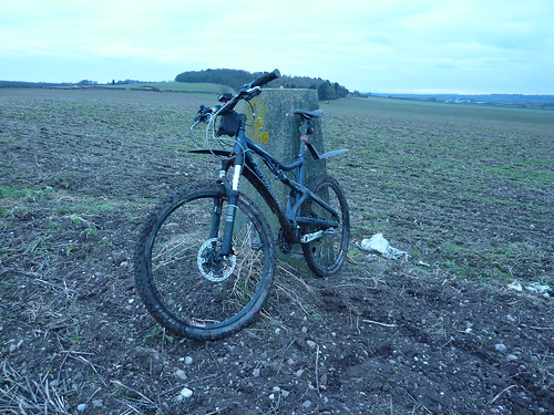 [/img]
Barrow Hill TP1060
[img]  [/img]
The Ridge TP6417
[img] 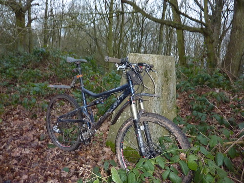 [/img]
Bunker Hill TP1767
[img] 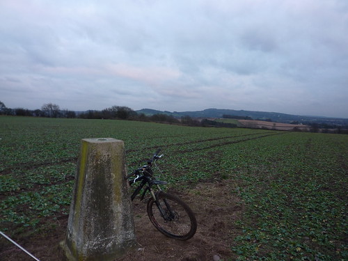 [/img]
Lea Castle Estate TP4380Bunker Hill TP1767
[img] 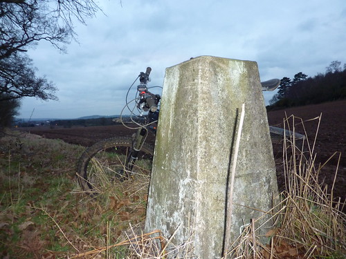 [/img]
Wimbury TP6957
[img] 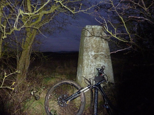 [/img]
Lea Castle Gardens TP4381
[img] 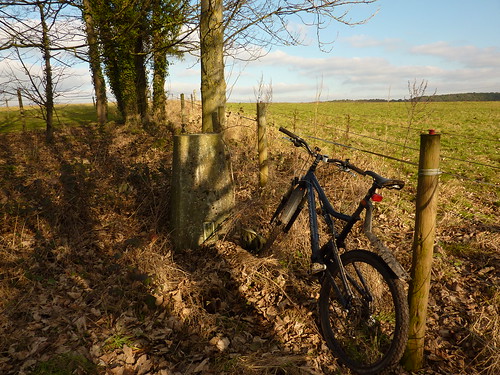 [/img]
Wolverley Road Nursery TP7023
[img] 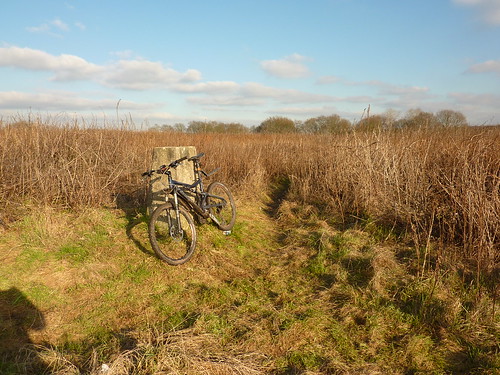 [/img]
High Habberley Farm TP3786
[img] 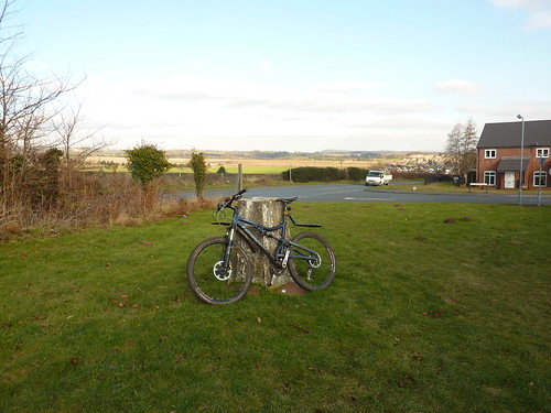 [/img]
Park Attwood TP5298
[img]  [/img]
Kinver Edge TP4244
[img] 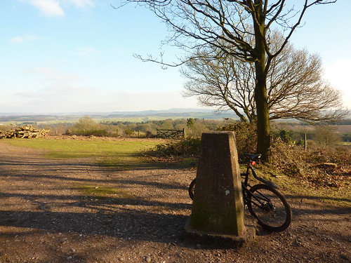 [/img]
Bracket plate photo's (proof) here if your that interested
http://www.flickr.com/photos/15253377@N00/sets/72157625799345381/
[url= http://farm6.static.flickr.com/5060/5395319709_fe95e1bea8.jp g" target="_blank">
[url= http://www.flickr.com/photos/15253377@N00/5395319709/ ]Kinver Edge TP4244[/url] by [url= http://www.flickr.com/people/15253377@N00/ ]z1ppy2[/url], on Flickr
Soma, check my previous post again, there was more to it than that.. but how'd ya get that link info?
On the B197
[img]  [/img]
The second nearest trig point to me (the first is in the grounds of a school).
[img]  [/img]
z1ppy.
You're brave going to the hollyhall cross.
Did any snetters try and nick your bike?
Not a trig point but a height marker type thing.
[url= http://farm6.static.flickr.com/5292/5395479967_04c1219a8b_z.jp g" target="_blank">
[url= http://www.flickr.com/photos/stu-b/5395479967/ ]fat heightpoint[/url] by [url= http://www.flickr.com/people/stu-b/ ]singlespeedstu[/url], on Flickr
@zippy
Went for the kill there 🙂 How many Trig points ?
---
PS Mine was BSM 3368
[img]  [/img]
about 4 hrs ago -)
singlespeedstu - Member
z1ppy.
You're brave going to the hollyhall cross.
Did any snetters try and nick your bike?
In and out, and back down the canal fast, but it was bloody chilly so maybe they all stayed home (sensible).
redthunder - Member
@zippyWent for the kill there How many Trig points ?
I have a feeling if Graham has the time, he'll outshine me by miles, so I thought I'd get in early.
I was lucky to be so close to so many of them, so I went for 13 TP's and a Rivet and got managed to get 12. I did get to all the locations, but went couldn't locate the rivet (side of the road, I didn't have a GPS position), also went to Bissells Wood but as I was loosing the light and couldn't see any sign of it, just horse paddock's. I thought better of investigating in the dark.
[img] http://farm6.static.flickr.com/5015/5397826183_dfff416ae0_z.jp g" target="_blank"> http://farm6.static.flickr.com/5015/5397826183_dfff416ae0_z.jp g"/> [/img]
19 miles around Delamere and Grestys Waste today, trails in excellent condition, still frozen/dry, with the odd soft patch where the the sun has broken through.
Haven't found the trig points we apparently have round here yet 🙁 Will give it one last go tomorrow.
Dammit. I knew I was meant to do something today. Knackers.
Trig point at Lundie Crags NW of Dundee
[img]  [/img]
I think this is the [url= http://en.wikipedia.org/wiki/Ha-ha ]ha-ha[/url] at Arley arboretum, marking the boundary between the lawns and common land beyond, although I could be mistaken and it could just be a retaining wall on one side of a sunken lane.
The idea of a ha-ha is that when viewed from the big house, on the right in this picture, there is an uninterrupted view of grass with no fences, while still keeping any animals from the common land off the lawn.
[url= http://farm6.static.flickr.com/5295/5398548690_2892167233.jp g" target="_blank">
[url= http://www.flickr.com/photos/8805115@N04/5398548690/ ]Picture 038[/url] by [url= http://www.flickr.com/people/8805115@N04/ ]Vegan Graham[/url], on Flickr
[IMG]  [/IMG]
Trig point at Ashover in Derbyshire.
SK 35848 63637
3 hrs ago 8)
Trig Point on Slieve Martin, Northern Ireland.
[img]  [/img]
now i got my trig points in on monday.........can i please choose this weeks challange?
pleaes
pretty please.............. 😀
[url= http://farm6.static.flickr.com/5091/5398197533_9f759fa311_b.jp g" target="_blank">
[url= http://www.flickr.com/photos/rocketdog/5398197533/ ]Trig[/url] by [url= http://www.flickr.com/people/rocketdog/ ]rOcKeTdOgUk[/url], on Flickr
[url= http://farm6.static.flickr.com/5056/5398200767_11fd7d7c04_z.jp g" target="_blank">
[url= http://www.flickr.com/photos/rocketdog/5398200767/ ]Trig II[/url] by [url= http://www.flickr.com/people/rocketdog/ ]rOcKeTdOgUk[/url], on Flickr
suggestion for future challenges..TV or Radio transmitters/masts
Trig Point on top of the Worcestershire Beacon yesterday afternoon
[img] 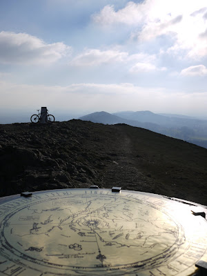 [/img]
England v Wales [Wye Valley] Welsh Side.
[img]  [/img]
[img]  [/img]
[img]  [/img]
Trig Point [survey station] in foreground when they built the bridge.
[img]  [/img]
--
Suggestion for future challenges:
Postboxes / Phoneboxes
Tractors 😉
Churches/Graveyards
Beaches / Rivers with the front wheel or both wheels in it.
Pill boxes
thats a good 'un.
WW2 and cold war stuff. Better not do modern stuff or we'll all be shot and killed dead and stuff 😉
None for me today, although i did get a couple of beach and pier shots (and some frozen roadies).
"Pylons"
IGMC
not really a sparkling effort from myself..
but it varied my route - did 33 miles - by the time I got home my left foot had gone a funny blotchy purple colour and I couldn't bend my toes...
TP4210
[IMG] 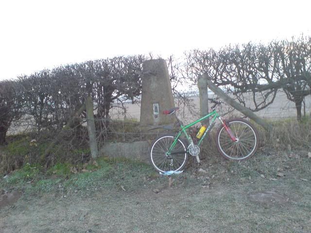 [/IMG]
Some good suggestions for future themes here. Keep them coming, I'm sure we'll work through them all eventually.
Beaches / Rivers with the front wheel or both wheels in it.
I like this one. I had an idea for "bikes under water" as a cryptic clue to see what imaginative ideas people could come up with featuring aqueducts and canal locks without actually dunking their bikes under water.
A mile post on the A56 near Lymm, made from cast iron.
[img] 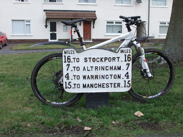 [/img]
How about Cold War ROC Bunkers?(known as Posts)
You will maybe need to do a bit research and turn detective to find one,
You will find one listed near you as there were around 1500 across the entire UK and Islands...
Above ground they look like this,1 of 6 here in my county,
[url= http://farm6.static.flickr.com/5255/5400710788_f96acd4087_b.jp g" target="_blank">
[url= http://www.flickr.com/photos/coastkid71/5400710788/ ]ebay 002[/url] by [url= http://www.flickr.com/people/coastkid71/ ]coastkid71[/url], on Flickr
[url= http://farm6.static.flickr.com/5091/5400112181_dee11a63f5_b.jp g" target="_blank">
[url= http://www.flickr.com/photos/coastkid71/5400112181/ ]ebay 003[/url] by [url= http://www.flickr.com/people/coastkid71/ ]coastkid71[/url], on Flickr
Find your local one or remains of one here;
[url= http://www.28dayslater.co.uk/forums/forumdisplay.php?f=50 ]urban Exploration forum[/url]
And if your lucky and its intact,unlocked and not vandalised you can have a wee explore like this 😮
[url= http://www.youtube.com/watch?v=hVcp0fR2HZs&feature=player_embedded ]http://www.youtube.com/watch?v=hVcp0fR2HZs&feature=player_embedded[/url]
Morning ride out on the 29er around the Staffs area and nipped up to this viewing platform/ trig point.Can any body tell me where this is?
[img]  [/img]
Great vid.
I know where a ROC bunker is near me.... Pheww I'm covered if this crops in the next exam 😉
Found it, turns out I just didn't look very hard 😆
[img]  [/img]
I ride that bike every day whether it's raining or not. The roads I ride tend to get muddy in the winter as well. So it's a mixture of mud and rust! Planning on giving the whole bike a full clean/grease as it's a bit noisy at the minute.
so it's rust then !
You should invest in a tin of 3 in 1 🙂
Phone camera today, lugged the decent camera up there but left the battery charging in the kitchen.
[img] http://www.flickr.com/photos/49960717@N08/5401458124/sizes/z/in/photostream/ [/img]
Botton Head [url= http://www.streetmap.co.uk/newmap.srf?x=459432&y=501594&z=3&dn=598&tl=TP0697+-+Botton+Head ]NZ594015[/url] Yorkshire moors.
[img] 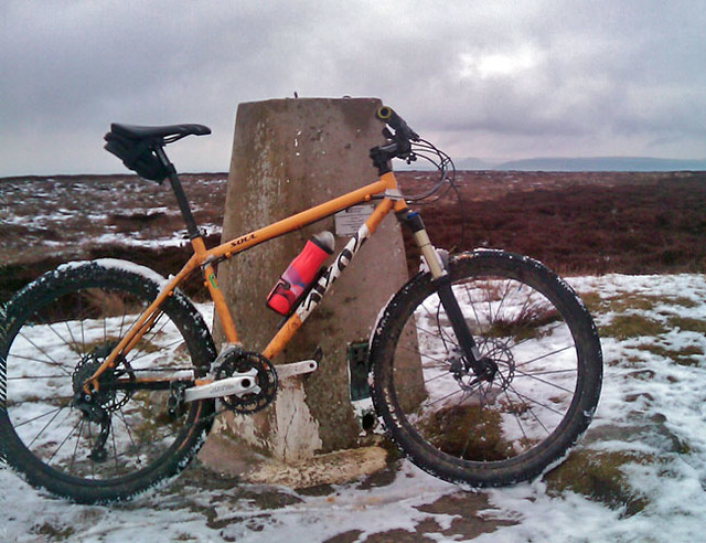 [/img]
Found that by accident, actually went to see the original a few hundred yards on.
[img]  [/img]
The Face Stone. Legend has it the expression changes to reflect true nature of the traveler's soul as they gaze upon it.
[img]  [/img]
All I know is it summed up how my ears felt at that moment in time.
Dammit! Also forgot
I managed to finally get out today, unfortunately the frozen ground of the last couple of days seems to have gone and i was left with Lincolnshires finest sticky mud.
The (second) highest point in Lincolnshire
[img]  [/img]
A whole 161m high. The highest point is 168m
An odd sign telling me the area of the woods i was in
[img]  [/img]
And the price i paid for riding in thick sticky mud
[img]  [/img]
Have done plenty of Mayhem/SITS etc in the mud and always wondered how people broke their frames/mechs. Turns out you just need enough mud on the lower jockey wheel to dive into your spokes.
Off to see the framebuilder at some point this week i think.
I've failed this week. I live about 3 miles from the Mason-Dixon line in the US, so should have been able to get something, but there's too much snow around to get out on the bike. Boooo!
Trig point on Twm Barlwm above Cwmcarn . . .
[img] http://images.fotopic.net/?iid=15y7v9&noresize=1&nostamp=1&quality=70 [/img]
[img] http://images.fotopic.net/?iid=15y7vd&=1&nostamp=1&quality=70 [/img]
Thanks for the inspiration - I probably wouldn't have gone up there were it not for the photo challenge - would've spent the morning in the woods instead - like riding indoors 😕 . What a cracking day . . . sunshine rocks!! 😀
[url= http://farm6.static.flickr.com/5295/5401511943_a12c9e8c7f.jp g" target="_blank">
[url= http://www.flickr.com/photos/15512491@N08/5401511943/ ]Maen Madoc[/url] by [url= http://www.flickr.com/people/15512491@N08/ ]ianbarrington[/url], on Flickr
Beside Sarn Helen - thought to mark the location of a Christan burial site - road side graves being a feature of Roman burials.
[url= http://farm6.static.flickr.com/5172/5401623581_5af1cb4ef0.jp g" target="_blank">
[url=  [/url] by [url= http://www.flickr.com/people/cakefest/ ]cakefest[/url], on Flickr
[url= http://farm6.static.flickr.com/5256/5402223002_7568160d58.jp g" target="_blank">
[url=  [/url] by [url= http://www.flickr.com/people/cakefest/ ]cakefest[/url], on Flickr
Rode up from home in Ludlow to the top of Clee Hill in south Shropshire yesterday. Started round field edges picking up a bit of mud and it had frozen on the bike by the time I got to the blustery trig point at the top. Now and again spots of golden sunlight burst through the clouds and lit up the orange dead bracken over on Brown Clee, the hill in the distance in the first pic. Stayed up there about 5mins then straight back down the same way - toad-in-the-hole for tea. Nicely.
More from the North York Moors, it was frozen and misty early on this morning.
Boundary marker stone near Captain Cook Monument. Says E on one side, T
H R
G A
14
Grade II listed too, marks the parish boundary between Great Ayton and Easby
[IMG]  [/IMG]
Another couple, marker stone and cairn from further over the moor.
[IMG]  [/IMG]
[IMG]  [/IMG]