I'm sorry this is so ambiguous but any help would be appreciated. I'm trying to sort a route out for Sunday and i've got an area stuck in my head that I cannot for the life of me remember where they said it was.
A while back (at least a year) there was a thread about lakes routes or something like that and somebody posted a pic, I'd love to know where it is.
The picture is taken from the trail. It has a steep gully to the left dropping about 50-75m ish with a small stream in the bottom maybe, and a gradual singletrack DH cut into the side of the hill on the right, about 150-250 m in the shot it turns to the right around the hill out of the picture.
It's a long shot but does anybody know where it is or something that sounds like it?
As a guess i'd say it's north lakes but i'm not sure.
Thanks in advance.
Hmmm could be anywhere but if your thinking north lakes my guess's would be Rigg Beck/Sail Beck to buttermere.... or perhaps the singletrack off Knott and down Burn Tod on Caldbeck..... or Gasgale gill even.
one of these?
[url] http://www.flickr.com/photos/71958789@N00/sets/72157625146971356/show/ [/url]
or these! 150 odd pics here of all the pics I have ever posted from the lakes.
[url] http://www.flickr.com/photos/71958789@N00/sets/72157626010575500/ [/url]
hmm, one of mine?
[url= http://farm1.static.flickr.com/198/452910128_7295e6e34d.jp g" target="_blank">
[url= http://www.flickr.com/photos/ir_bandito/452910128/ ]P4060009[/url] by [url= http://www.flickr.com/people/ir_bandito/ ]ir_bandito[/url], on Flickr
[url= http://farm1.static.flickr.com/188/452925721_03b7db0e5b.jp g" target="_blank">
[url= http://www.flickr.com/photos/ir_bandito/452925721/ ]P4060008[/url] by [url= http://www.flickr.com/people/ir_bandito/ ]ir_bandito[/url], on Flickr
Sounds like the back of Skiddaw route. Heading south on the trail 1km to the east of Lonscale Fell.
Though could be any of the above!
Thanks for the replies, STW is great for this! I think it could be nicks picture but further down the trail. Where is that?
[url= http://www.flickr.com/photos/71958789@N00/4703801951/in/set-72157626010575500/ ]Clicky[/url]
Nick do you or anybody else have route?
Thanks again.
EDIT: Sofatester... that's it I think!
[img] 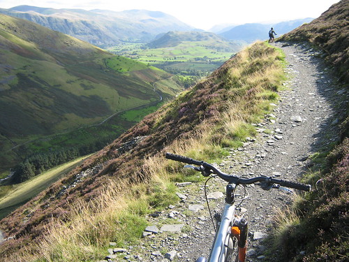 [/img]
Nick's piccy is coming off Harter to Nan bield
[url= http://farm5.static.flickr.com/4023/4690842169_59dcc32420_o.jp g" target="_blank">
[url= http://www.flickr.com/photos/dave-lowe/4690842169/ ]IMAG0428[/url] by [url= http://www.flickr.com/people/dave-lowe/ ]lowey.com[/url], on Flickr
[url= http://farm5.static.flickr.com/4062/4691480868_b809eb5251_o.jp g" target="_blank">
[url= http://www.flickr.com/photos/dave-lowe/4691480868/ ]IMAG0434[/url] by [url= http://www.flickr.com/people/dave-lowe/ ]lowey.com[/url], on Flickr
[url= http://farm5.static.flickr.com/4034/4691448824_009a3ce57d_o.jp g" target="_blank">
[url= http://www.flickr.com/photos/dave-lowe/4691448824/ ]IMAG0402[/url] by [url= http://www.flickr.com/people/dave-lowe/ ]lowey.com[/url], on Flickr
[url= http://farm5.static.flickr.com/4017/4690829397_4c7895ba70_o.jp g" target="_blank">
[url= http://www.flickr.com/photos/dave-lowe/4690829397/ ]IMAG0416[/url] by [url= http://www.flickr.com/people/dave-lowe/ ]lowey.com[/url], on Flickr
Perchance ?
Here?
[img] 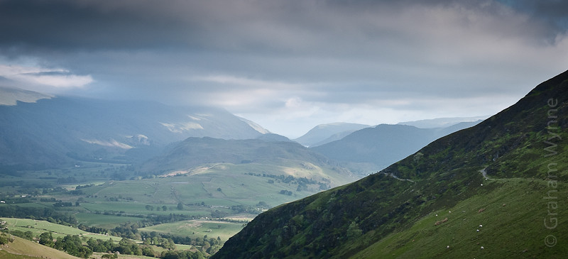 [/img]
Wozza, that pic is [url= http://www.streetmap.co.uk/map.srf?X=329337&Y=527000&A=Y&Z=120 ]here[/url]
That's pretty much where mine is too.
Yeah Nicks is Harter to Nan Bield. Can be incorporated into the classic Nan Bield Route, but by going over Harter Fell you miss Gatesgarth Pass and superb run down to Haweswater.
Nan Bield figure of 8. and you get it all...
😉
Haweswater - gatesgarth - harter - nan bield - kentmere - garburn - yoke - ill bell - high street - mardale - nan bield - haweswater
Proper mans day out!
Thanks for all the replies, I think you've found it! (and if not they're all worth doing anyway. 😀 )
FRN... with that route though you still miss out Gatesgarth to Haweswater, which, imo is the better of all those descents. Although Mardale Ill Bell to Nan Bield would be good in summer I reckon... nearly killed me in the snow.
IMO thats the most boring!!
Ummmmmm, due good weather on Thurs - anyone fancy an evening ride to include Rigg Beck and a sociable pint? 6pm start? anc - break your Wed eve habit?? Be needing lights soon.
Bump! For a Rigg Beck/maybe Grisedale Pike ride tomorrow (Thurs) 6pm?
boxelder - could do tomorrow daytime but not evening? I'm very unfit though! 🙂
6pm at the earliest for me I'm afraid
Would love to mate, but too much of a trip of a night time for me 🙁
Hia, sorry missed your invite. Went out last night as usual, 😳 managed to put and nice hole in my shin after a disagreement with a rock and a over the bars incident dropping into Dalehead tarn.. Ouchy! So will be mostly licking my wounds tonight, theres no chance the boss will let me out 2 nights in a row either, more to the point. 😛
Twas near perfect. Stoneycroft was nicely in the shade, walkers at the col were friendly (and suitably impressed) and the descent felt blur speed. There's even a dead sheep in one of the muddy gulp pits, acting as a bridge - it's no longer living OK, what harm can it do.
Making the shift from CX bike to full sus took some getting used to though!
