UPDATE: Reviews section refreshed, redesigned, searchable: Go take a look
Well unofficially at any rate.
We hit a milestone yesterday with the volunteer twisty in the trees bit and linked up with the old red route on the fireroad. Started a new section as well to bypass some more fireroad.
Contractor bits are all now rideable and open, all the obstructions have been removed and some limited signage is up. Full route marking should be done in the next couple of weeks.
So if you fancy riding some of the biggest berms you've ever seen feel free.
The trails will officially open when all the route marking is done but they are happy for people to ride the tails before then.
Perfect im up in Skipton for a family gathering for a few days at the end of the month and i was just looking for somewhere to head on the bike.
How easy is it to find the good stuff? Any rough maps available yet or a place to start from?
i should be up there this weekend testing the new trek 🙂
anyone else going?
This is the original trail builders plan. it's not been updated so difficult to see what bits of it are finished and what isn't. Maybe you can use it in conjunction with an OS map. You should be able to find the Quarry, there's a long section out of the back of it which stumpyjon said was finished (i think), it's basically the long yellow highlighted bit up the top right, but there are other sections to find. The bit highlighted in pink on the left, is the volunteer build and is finished bar the odd bits.
[img] 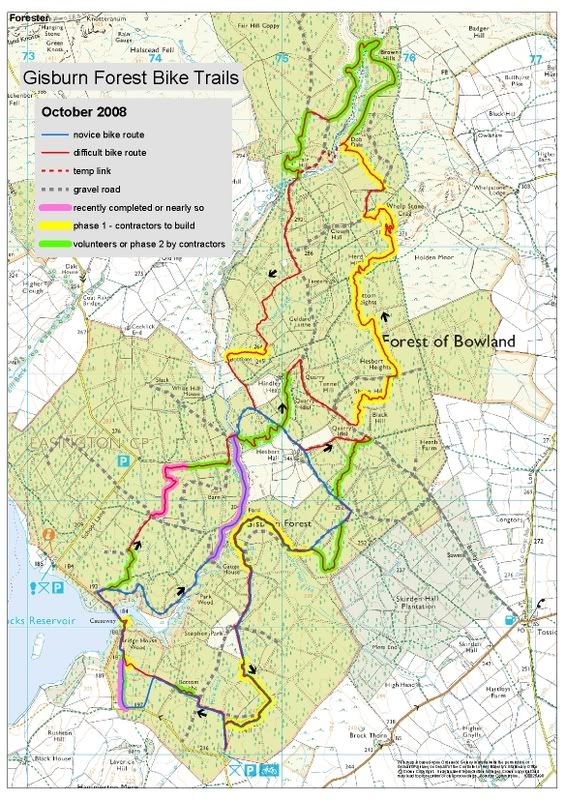 [/img]
This is the stone pitch staircase finished on Sunday. it's steeper than the pic suggests
[img]  [/img]
This section is especially good, swoops criss crossing this steep sided gully down to the bottom of the hill
[img]  [/img]
Wall-ride-tastic! Going to have to have a quick drive out there sometime for a play.
[img]  [/img]
wow, this looks pretty incredible! I shall be going soon.
Lowe/junkyard up for a ride?
Have to say - this does look cracking, another great trail centre within an hours drive is always good!
That looks class, and only 45 mins drive from Preston! spoilt for riding round my way like!
that looks really really good - defo going to get at least a day up there soooon.
I'm going up tomorrow night and will log the route on my GPS. I'll download it and take a screen shot of the new and old red routes on one map and try and post up here.
Having ridden it all before i can confirm it is indeed of a very good standard. Plans are being made for toilets and cafe and they are already looking for more funding for a skills park.
Plus the volunteers are still building, once we've completed the section we started on Sunday we've got a couple of options, another descent line on the roller coaster section or I think our preferred option is to build some woodwork features running parrallel to one of the existing fireroads.
Neil - give me a shout if you are planning to go. I'm free most days!
JxL i'm away in France next week but the week after definately, one night after work? I finish at 4 so can do anytime around 5? be a good place for a couple of hour blast around by the looks of it? 😀
Jon thats ace, I couldn't make it to dig at the weekend but I did have a ride round the route the other week and it was ace. The stone pitching took a lot of work! Those big rocks didn't get up that hill by themselves! I remember at the dig previous pushing on my hands and knees a ****ing big rock up that slope. I can say that the trail is very good.
enjoy
2hottie
Scott
the next bit is going to go way faster, we dug out about 40 yards and put a base layer of stone down over most of it with 8 of us in 2 hours. Stone is right next to trail head, the soil is dry and there aren't too many roots. I much prefer trail building when we measure progress in yards per hour rather than rock per hour.
That Gully looks ace.
Looks good, will have to go and have a proper look. Same contractor as Lee Quarry?
Read somewhere else this is on United Utilities land - is this true and how did you get them to go for it?
I agree yards per hour is much better than rocks per hour,
Anyway the stone pitch is a great feature and makes the route that little bit harder!
Unsure about the U an U land but the guy who help to organise the digging at Gisburn works for U an U and is a massive bike fan so was easy I guess.
Yeah Neil - that sounds good.
The land at Gisburn is owned by United Utilities and the Forestry Commission are then tenants of UU. Luckily for us both Nigel Pilling, the UU guy on the ground and Martin Colledge the FC man on the ground are both mountain bikers and it's been their concerted effort over the last four years or so that has got this off the ground.
Different contractors to Lee Quarry, Martin wanted to use local contractors. Rowen Sorrel has given advice and I believe one of Rowen's guys has supervised the contractors.
The twisty tight bit through the trees has all been done by hand with volunteers which is why it has that unique character, we didn't have to clear the trees to get machines in.
This looks great.
Another 'ride after work' possibility being an hour from Warton.
look fwd to the map and piccies stumpyjon
It looks awesome well done to everyone involved! I've been meaning to get over and help with the trail building but been away at Uni. I'm on the facebook group anyway so will be on the lookout for dig days now I'm back in the area 🙂 Now just to get car insurance sorted...
Next dig day is a week on Sunday. Now get you car insurance sorted....no excuses 😆
I think (hope) Gisburn is going to be very good. If what Martin Colledge (the head FC forester) says, happens, then it's going to be a mix of Dalby XC and Stainburn/Lee Quarry Technical. So, a good long fun XC ride with Black technical features along the way, for those that want to do them (We've yet to see how 'technical' Martin is prepared to go).
Something else from Sunday, they are going to start charging for parking in the main trailhead car Park (currently free), proceeds going to trail maintenance. However, we discussed a free parking pass for people who do some dig days, as an incentive to turn up and build trail. This would be similar to the arrangement SingletrAction have in Yorkshire for a Dalby Forest Pass, if you do 3 dig days at Dalby, Stainburn or Wharncliffe.
i'm away in france for the next two weekends but i'd like to get involved with the digging? i'm only in preston and i reckon a mate of mine will come along too? emails in profile if you could email me the details?
Neil, sent you an email last night.
Anyone else want details, just ask.
stumpyjon YGM, also emailed martin, should be there the one after next 😀
So we finally made it out to the fire road! Woohoo!
Won't be able to make the next one but i'll be there for the dig day after that.
[img]  [/img]
I think this one might be a climb.
[img]  [/img]
Text on this reads:
That's Nikki of Rowan Sorrells Company, he project managed the local contractors.How many lines! If you like 4x you're going to love this! I'm thinking the name 'The dragon's teeth' may be appropriate with a nod to our welsh trail designer - cheers Nikki!
[img]  [/img]
Rode the new route at Gisburn tonight. Clocked it at 12.7 miles on the GPS and 13.5 on the Cateye so take your pick, guess it's around 13 miles. 1450 ft of climbing and it's bl**dy brilliant. Rode some of the blue bits today as well.
GPS output below:
[img]  [/img]
Some excellent bits, took loads of pics, all the pics are [url= http://stumpyjon.pinkbike.com/album/Gisburn-Forest/ ]here[/url].
Choice pics below:
Nice bit of boardwalk.
[img] 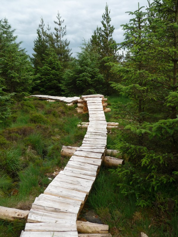 [/img]
Nice techy bit, fall off and get wet 😆
[img] 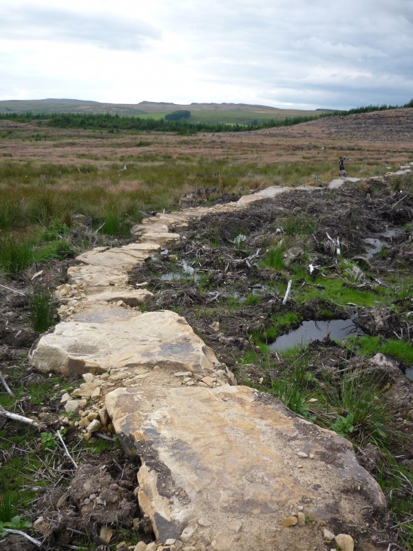 [/img]
Top of an optional black bit.
[img] 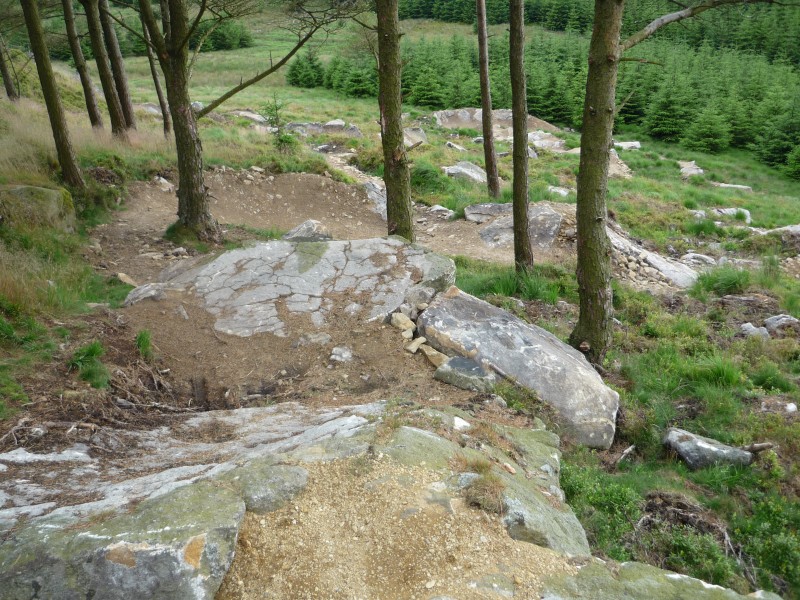 [/img]
Silly slab on the black loop, gotta be 70 degree slope and 15 / 20 ft drop 😯
[img] 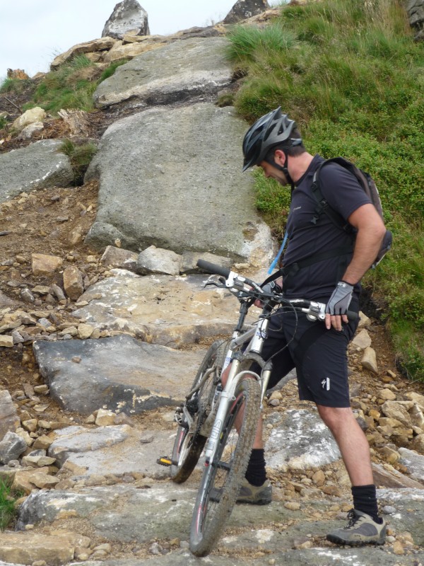 [/img]
Bermtastic, these berms continue for 7 or 8 switchbacks 8)
[img] 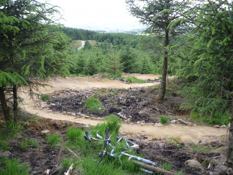 [/img]
Exit from the rollercoaster, through a ruined building.
[img] 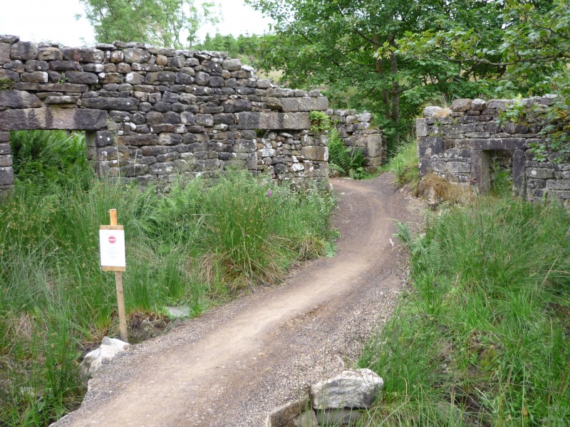 [/img]
All looks fab - mrdomino went up there this afternoon and enjoyed it while I was slaving over a hot computer 🙁 Will have to get up there soon.
That does look good, I've been holding out till it's properly open but tomorrow night it may get a visit.
stumpyjon - Member
Neil, sent you an email last night.Anyone else want details, just ask.
takamush@live.co.uk please been riding there since i was three better get my arse there at sometime
That slab looks a lot less steep than 70 deg in that picture, more like 30 t 35 - but I shall withhold judgement until I've ridden it. Is the 13 mile loop easy to ride if you haven;t been before or shall I wait until thr waymarking is up?
Nice pics Jon.
The solution to non-slip wooden raised trail looks interesting. I looked at it months ago on the small bridge on the volunteer build section, I've never seen it used elsewhere. It looks like it's been axe split end on, which would be quite labour intensive for a long section. I'm curious to know how it's actually being done. Personally, I think 'Knackerisation' is still a genius solution for lateral grip whilst still keeping it looking reasonably 'natural', someone with a chainsaw could make short work of knackerising it:
Examples of Knackerisation at Stainburn
[img] 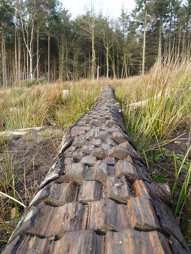 ?v=0[/img]
[img] 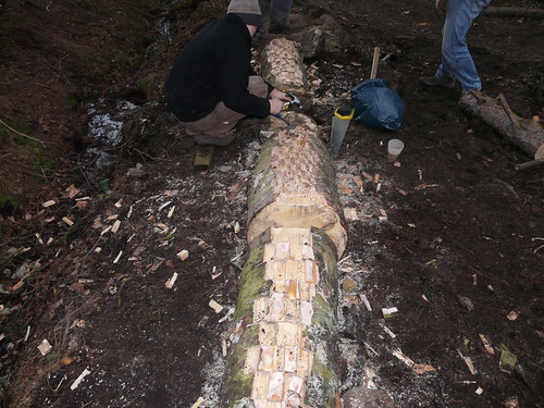 [/img]
That slab looks a lot less steep than 70 deg in that picture, more like 30 t 35 - but I shall withhold judgement until I've ridden it.
Yes,please do reserve judgement.Okay,maybe not 70 deg,but not far off!
See the following photo,taken 10 days ago,the bike was propped up vertically,hopefully it'll convey the steepness...
[IMG] 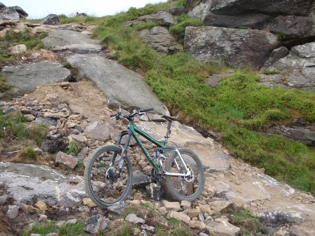 [/IMG]
Was up there with a mate yesterday eve,(Weds),rode the whole route,& some of it twice,(the bermed gully run),& we came away impressed with the work thats gone on there.
Actually, in that photo it looks more like 30 degrees, don't forget 90 degrees is vertical. 70 degrees would be very very steep.
But, all these pics makes Gisburn look superb and a step up 'next generation' from many other centres.
Actually, in that photo it looks more like 30 degrees, don't forget 90 degrees is vertical. 70 degrees would be very very steep.
Point taken 🙂
Having been down the 'Gisburn Slab' 3 times so far,i'd say its at least as steep as this:
[IMG] 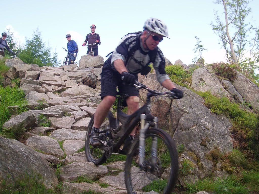 [/IMG]
(Dalbeattie qualifier).And that photo doesn't do the steepness justice either!
and a step up 'next generation' from many other centres.
I'll say.Was particularly impressed with the 'lets put timber over the boggy ground'solution.i.e. use what looked like hand split logs rather than the smooth machine cut slippy timber at other centres.
Hopefully this trail building at Gisburn will be just the start.
This is me on the Dalbeattie Qualifier which is also probably no more than 30 degrees steep (I went over the handlebars a split second later 🙂 ). On a bike, short steep sections look/feel much more than they actually are, especially where rocks are involved.
[img] 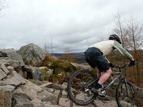 [/img]
Can see I'm going to have to use my iphone to measure the angle of the slab, it is very very steep, way over 45 degs.
The new boardwalks are excellent, almost muscial, if you ride them you'll know what I mean.
Tom, you got mail.
