Is there any way of adding Core Paths to Google Maps ?
Core Paths are mapped as a layer here, for example:
https://map.environment.gov.scot/sewebmap/?layers=corePaths&extent=261367,685689,277661,696904
I could draw the Core Paths into Google Maps by hand, but there has to be a better way.
Background:
A group of us are mapping gates and barriers that are obstacles to access for users (fences, locked gates, cattle grids without bypasses etc).
We map these on Google Maps. Pins get dropped at an obstacle, we describe it and add a photo.
At some point - and it does sometimes happen - the obstacle gets removed.
Thanks!
I've created personal Google Maps using a gpx-to-kml converter. Is that what you're after?
My gut feel is Open Street Map might be better.
I find adding anything to Google Maps incredibly frustrating and anything you do needs to be 'verified' by a Google algorithm (it seems ropey at best). In the end I ended up leaving inaccurate data up as the algorithm wouldn't allow me to change it.
Having said that you can load gpx files and create your own maps in Google's My Maps - https://www.google.com/maps/d/u/0/
There is a way of transferring stuff you make in My Maps to the main Google Maps but I can't remember exactly how to do that.
Having said all that, I added some Sustrans waymarkers to Open Street Maps (using the instructions in their Wiki) but someone came along and told me off for something or other and deleted them!
I’ve created personal Google Maps using a gpx-to-kml converter. Is that what you’re after?
If core paths are available as gpx files - that could work.
(I see Shetland Council do this). Could always email NatureScot and ask...
Open Street Map might be better
Does this enable open collaboration ?
We've found that Google Maps allows us to quickly collect a mass of data from volunteers. Guess I could then export from Google Maps to Open Street Map....
Wonder if I can get access to the Core Path map from here:
https://data.spatialhub.scot/dataset/core_paths-is
Maybe something like Qgis is what you need?
Yeh I got Shetland core paths and access routes loaded up as individual gpx files when I worked there, nice to see someone's noticed 😁. We did try to do it so that you could download one file with them all on, but we just couldn't get it to work reliably for all platforms despite lots of effort from the tech team.
There has been discussion on and of with OS about getting core paths on their maps since the creation of core path plans, but despite their statement that it's something they'd like to do at some point they always have an excuse why they can't.
I'm no longer in shetland,so I'd love gpx of where I am now (Angus) for the mapping app I use (maverick gps), but short of plotting them all myself in Strava from the spatial hub it's not looking likely. Maybe I should just crack on with that 🤔
I'd probably take the shapefiles from that link up there, pull it into qgis with Google aerial as a background, and digitise from there. You can then export to whatever format you need, within reason.
If you're ground truthing or collecting in the field, I'd set it up for data collection using an app on my phone, probably "mergin maps" (android and ios) or "qfield" (just android).
All software mentioned above is open source and free. Feel free to DM me if you want more details.
Edit: just tried to download the shapefiles for a quick play, turns out they're not freely accessible/available from that link.
Edit 2: some data seems to be available as shapefiles on the data.gov.uk site. Which area is it you're looking at?
I find adding anything to Google Maps incredibly frustrating
That's not the intention.
The map is for us to then share with relevant authorities. No intention of adding to "THE" Google Map.
The current obstacle map for the Touch Hills looks like this (work in progress):
https://www.google.com/maps/d/u/0/edit?mid=1yZRspWxcaZqqz-_bQJXxpBzK1C2sEBs&usp=sharing
@cleetonator
Thanks for the suggestions - I will go and take a look.
I am currently looking at the Touch / Gargunnock hills (which is Stirling / Falkirk LA). Also have a map for all of Stirling LA as a bigger project.
I am not a mapper but somehow get roped into helping out with this after a friend got her cargo-bike loaded with children stuck on a cycle path.
My old tech guy says...
you should mention they can convert shape files to gpx in QGIS, they’ll need a separate one for each route, that was the issue. Most LA’s (like us) will have them all in one layer and gpx files don’t appear to like that. So I had to separate each route to its own shape or mapinfo file, open in QGIS and export as a gpx. There are probably cleverer batch ways of doing this but I couldn’t find an easy one that didn’t mean buying something.
As above desktop QGIS is free,but you need the shapefiles first. Maybe a direct request to Stirling OAO?
Hope that helps
Longdog - thanks!
Stirling OAO
Currently not my best friend after I suggested their response to a clear breach of access law wasn't strong enough. I'll ask anyway.... 🙂
The current obstacle map for the Touch Hills looks like this (work in progress):
https://www.google.com/maps/d/u/0/edit?mid=1yZRspWxcaZqqz-_bQJXxpBzK1C2sEBs&usp=sharing/blockquote >I looked at your link as round our way farmers have deliberately obstructed paths with fences/locks etc etc, even put huge diversions in from the OS Map without any justification other it goes near their house.
Some of yours look a bit OTT though eg the stuff thats overgrown, or too narrow. Surly thats just how it is?
Surly thats just how it is?
Depends.
Some of these tracks are core paths and others are promoted as active travel routes or promoted as local walks. Others are just there and are used by locals.
We've found it best to document everything. You then sit down and filter them, prioritizing by issue, need and ease-of-solution.
The Land Reform Act (2003) helps and core paths have additional protection: gates should not be locked, cattle grids should have bypasses.
Here the local horse riders want to put a Gravelfoyle-style circuit in. There is hopefully money available to solve the issues once we identify them (for cyclists and horses and walkers).
I'd use Qgis personally.
set up the shapefile to have fields for each aspect you consider.
then set up a field to calculate the score
set up the symblogy to get redder or bigger by priority.
Council shouldn't have an issue with the shapefiles.
If you know what the corepaths are, i bet you a fiver you can get the physical route as an xml from open street maps.
BAsically everythign you want to do is really quit ebasic in QGIS and well do alot for you.
You can have the whole thing on one drive if multiple users want to use it.
QGis should be able to directly pull OpenStreetmap data and then you can 'style' your map by looking for the designation=core_path tag on paths. If the idea is to get a lot of you collaborating on map data then it really is worth spending the time to learn openstreetmap. Individual people can edit the map directly online at https://www.openstreetmap.org/ once you have created an account. It's been a while since I've done it but the tools are improving all the time and there are a lot of great QGIS tutorials around. Initial learning curve can be a little steep but the built in tutorial is good
YEah openstreet map can be brought in but the designation is NULL for stirling (they seem particularly cagey about supplying the data compared to east lothian that tells exactly how to get the shapefiles 😀 Surely this falls under freedom of information request?
Anwayz... Google maps background on qgis with Tracks overlain from OSM, 30minutes of setup and I had the points to the tough reservoirs in with a description and a score 1to5
Thanks everyone.
Had not heard of qgis before so will go play...
@StirlingCrispin... assuming you still have his contact details 'Other Crispin' works with this kind of stuff (or certainly did)...
Had not heard of qgis before so will go play…
its great, don't be put off atthe start.
Install QGIS
Install https://openwebstart.com/download/
Install JSOM https://josm.openstreetmap.de/ and run it
Open QGIS and in the browser on the XYZ tiles right click and makea new connection
https://mt1.google.com/vt/lyrs=s&x={x}&y={y}&z={z} paste that in to the relevant box
Thats you set up to play
Thanks Josh - will go and play.
Richard - good shout. Recently shared a route with the 'other Crispin' as he was exploring these hills. Will invite him to collaborate / do all the work.
Oh yeah in QGIS you need to load QuickOSM plug in in the plugin menu at the top.
QGIS is a bit of a "Blank canvas" software so definitly try the tutorials.
As well as OSM, the OS also provide a range of data that you can use in QGIS, such OS OpenMap Local or OS Open Zoomstack OS Open Data Hub. You may well find that the forest tracks and paths are already captured in these products, so you can easily filter them out.
you can get full fat OS mapping as your base map, and load that into a Qfield space, easily enough.
you can almost certainly overlay the core paths layer too.
All contributers will need to install Qfield, and open a Qfield account though ( i think)
Youll have to excuse the gopping colour scheme, but a bit like that....
just looking to see how it handles on mobile through Qfield
Reverting back to your original question, if you want the core paths layer loaded into Google maps, I can download it as a kml,and it loads straight in, though it does have a 2000 feature limit on the upload to Google mymaps. If you know specifically what you want to show, we could cut down some of the feature classes. Is it just the lack of ROW data on Google maps you are trying to fix?
Thanks.
Specifically - I am trying to fix the lack of Core Path data on Google mymaps.
I am going to play with [edit] QGIS now, but if you could export a kml for me that would be awesome. Will message with my email. Thanks!
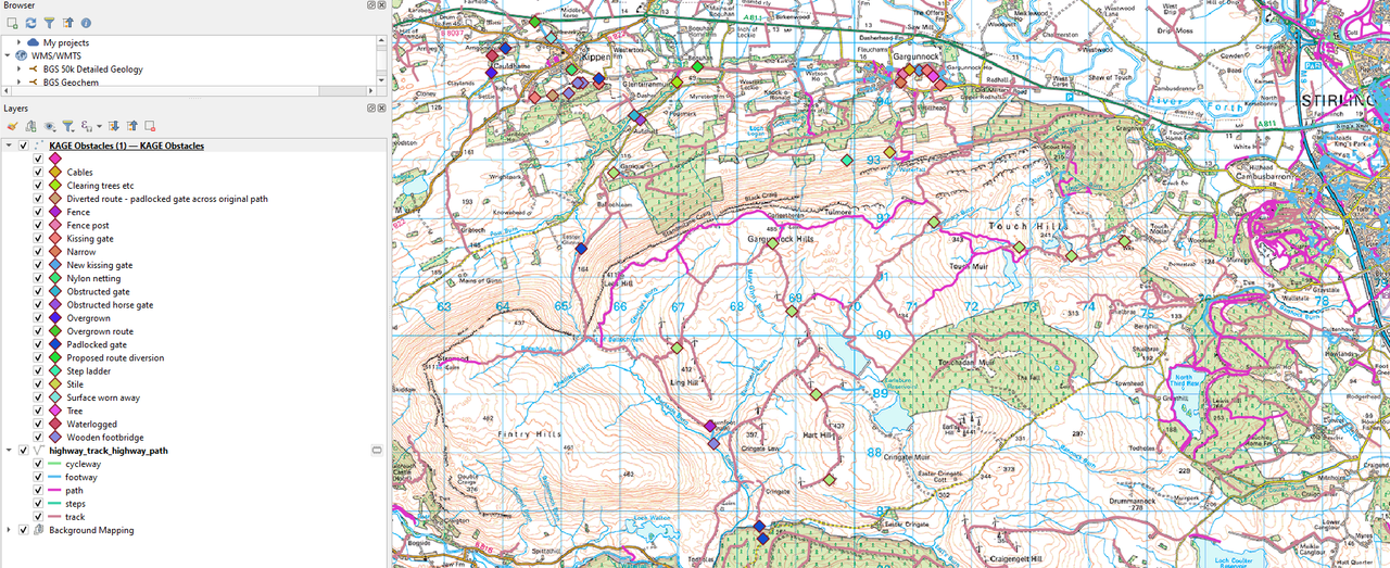
So, there is a function/plugin in QGIS that as far as i understand scrapes/mines the Open Street Map server and delivers the content behind the mapping as geometry for you do with what you will. This is of course limited by:
Does OSM have it mapped correctly.
Have you (I) queried it properly!
Having said that
https://www.google.com/maps/d/edit?mid=1RHoEUOLzWPR8g-hg2Twq0zz-fua0M2I&usp=sharing
Ive downloadewd two parts:
Highway Lines, styled by path type
Highway Nodes (basically any "point" feature they deem worthy of mapping) styled by barrier type.
I wasnt sure of your extents so have drawn a line around that hill, along the roads, and added 500m.
You can certainly use this as an assist to pinning "issues" on google maps, and this will probably have the lowest barrier of entry for multiple users.
Once youve got your Pins, you can potentially pull them into QGIS and do some nice fancy mapping and analysis for presentation to whoever youre showing it to, but as far as i can tell its a one way download/upload thing, rather than a "live" connection, so you would only want to do this as an when it relevant, ensuring you have the most up to date version at the time?
Ill email you the KMLs.....