Finally got round to putting my photos from our roadtrip round the highlands and skye on the net, a few pretty ones below, lots more here: [url= http://www.flickr.com/photos/25896460@N00/sets/72157622131787966/show/ ]http://www.flickr.com/photos/25896460@N00/sets/72157622131787966/show/[/url]
I want to be back on holiday!
[img] 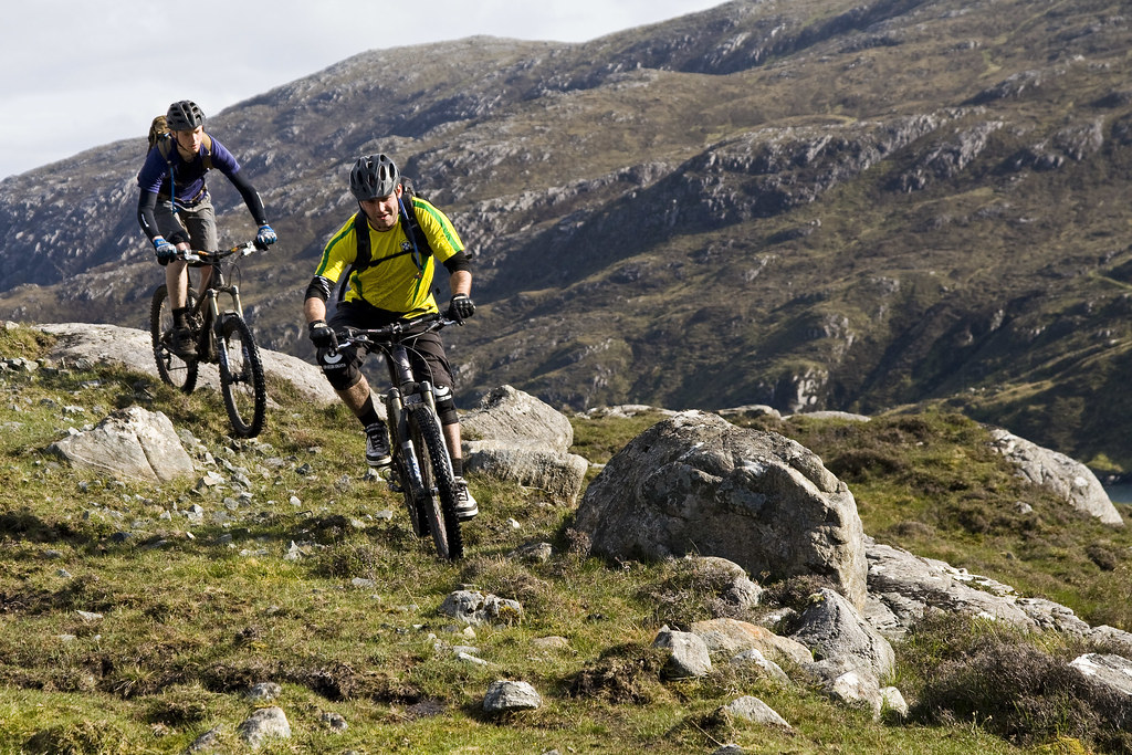 [/img]
[img] 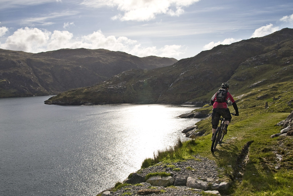 [/img]
[img]  [/img]
[img]  [/img]
[img] 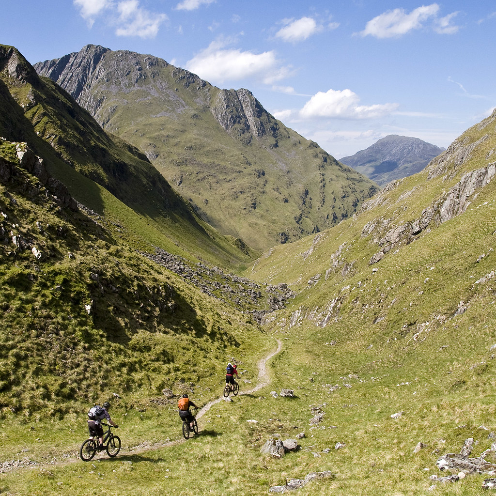 [/img]
[img]  [/img]
Looks nice!
Where is the second to last photo that you posted? All looks great I must say. You even got the weather.
Fantastic Stuff, really want to do a trip like this. what was your trip outline?
Fab
Great shots!
Second TJ, where is that second to last photo from (even a rough location will do 😉 )
We didn't really get the weather! I just didn't get the camera out when it was pouring with rain... e.g a mate took this on Skye:
[img]  [/img]
It was two foot deeper when we crossed it on the way back, and considerably more sketchy!
The second to last photo was taken near Glen Affric (sp?). Properly good descent (possibly the best one in the UK I reckon when taken as a whole), one of only 3 descents to have given me arm pump in the UK (the others being a descent on Lewis, and the Snowdon ranger path). As near to the alps as you'll get in this country. Location is here: [url] http://www.streetmap.co.uk/map.srf?X=201215&Y=821455&A=Y&Z=115 [/url]
Before someone moans at me for posting the location, it's a) in the middle of knowhere in the highlands b) it's a good 6 hour ride (well push across bog really) to get there unless you push up it - we stayed at the youth hostel over night.
Here's a photo from the bottom end of the trail.
[img] 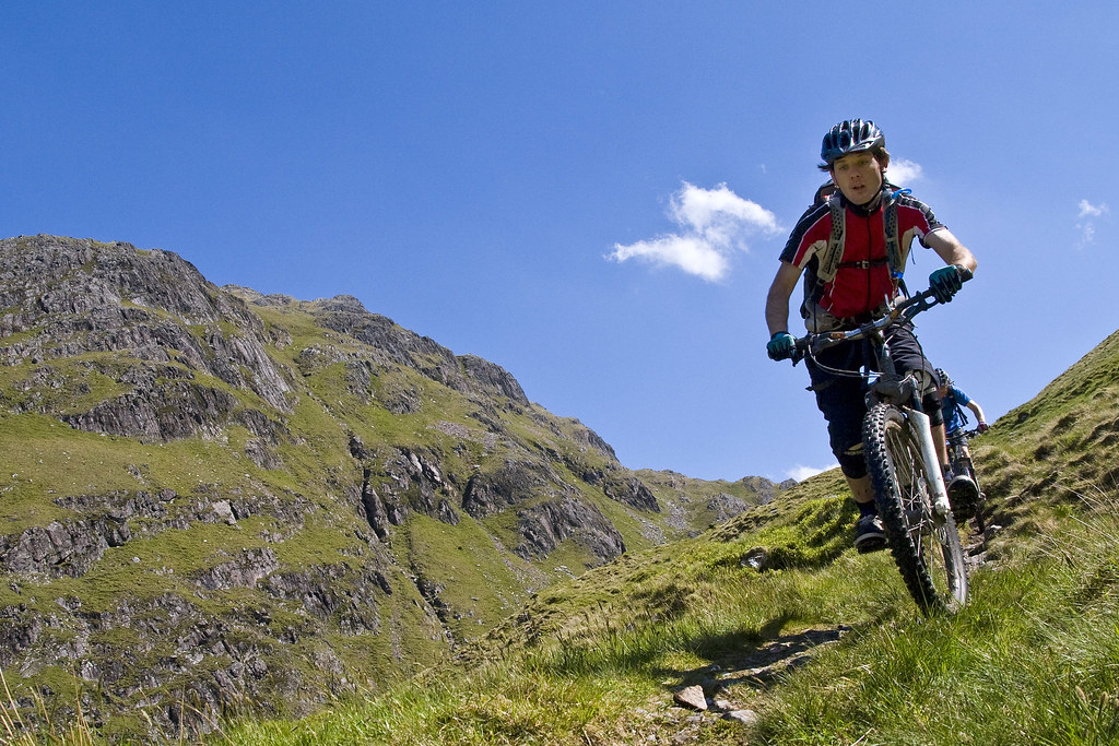 [/img]
Freeride Nick - Our trip went thus:
Day 1 - Drive to Skye.
Day 2 - Ride a trail in Skye
Day 3 - Go to Harris / Lewis and ride a trail on Lewis
Day 4 - Go to Lewis ride an epic trail on Harris
Day 5 - Drive back to the highlands going via Apple cross, having lunch, and checking out monty halls crib
Day 6 - Go to Torridon and climb a munro before tea
Day 7 - Ride round torridon
Day 8 - Drive to Loch Lomand and stay at YH
Day 9 - Drive home
That's only 9 days. We were there ten days. So i've missed a ride out somewhere. Where ever that was, it would have followed this pattern:
- Rain
- Bog
- Sunshine
- Epic descent to make you forget about the bog / rain.
Ah. I missed out the Glen Affric overnight ride.
>Before someone moans at me for posting the location,<
would be churlish - it's written up in several books:-)
Brill thanks....
Ahhh... yep, know the one, a mate came back from riding it a couple of weeks ago saying how good it was.
Thanks for the pics!
Ewan, thanks for that. I'm luck enough to live in Highland, but haven't done that descent into Affric. I reckon I'll do it the next dry weekend tho. Just need to talk someone into dropping me at Kintail and I could Coast to Coast it home.
No probs. At a push (litterally) it'd be fine in the wet. The bog will still be a bog, so that makes no odds and the rest is hard packed rock trail.
Looking out the window right now the weather in the Capital of the Highlands is definitely not sunny.
The trails you see are good most of the time.
Glad you enjoyed it up here the rides are stunning.
Swayndo i'm all over that like a rash. I'll give you my moby no on Facebook. You're bound to need a fun to be with riding buddy for that one even if it just to make you look good. 🙂
Brilliant photos Ewan.
The second to last photo looks like the trail down into Glen Lichd with Ben Attow on the left. I've often thought of riding it but never got round to it yet. Walked up there last November and thought it would be a really testing descent and only really do-able in dry conditions.
Got me plotting...
Ewan - so is that descent going into or out of Affric? Ie east or west?
Goes east on the map i posted. It would be properly rubbish going the other way.
Cracking photos mate - one of the best roadtrip slideshows I've seen.
I foolishly did that descent as a climb last year when I was up on Skye, rest of the ride had no descents like that would have been - ah well!
Definitely agree about the bog, also found the path very vague in some bits.
I parked at the end of Loch Duich, up the good descent, then doubled back at the Youth hostel and returned via Gleann Lichd. Lovely scenery.
Ta Ewan. How beastly was the climb? I want to do some riding in the area having walked there a few times. Mrs TJ tends to spit the dummy if there is too much hike a bike.
We went from the youth hostel ([url] http://www.streetmap.co.uk/map.srf?X=207910&Y=820295&A=Y&Z=120&ax=207940&ay=820220 [/url]) along the obvious path. That took a good few hours and was only about 50% ridable.
You could push up the ascent. It'd take ages, but it's mainly hard pack. You could probably MTFU and ride most of it. You'd loose the epic wildiness feeling tho you get from going at it the long way round.
We started here (mountain rescue post carpark):
[url] http://www.streetmap.co.uk/map.srf?x=196095&y=821095&z=120&sv=196095,821095&st=4&ar=y&mapp=map.srf&searchp=ids.srf&dn=671&ax=196095&ay=821095&lm=0 [/url]
We went along this double track (all rideable):
[url] http://www.streetmap.co.uk/map.srf?x=199120&y=818320&z=120&sv=199120,818320&st=4&ar=y&mapp=map.srf&searchp=ids.srf&dn=671&ax=199120&ay=818320&lm=0 [/url]
Went via this path to the youth hostel, about 50-70% ridable I'd say. We generally strap it on and MTFU but some of the climbs required sticking bike on back:
[url] http://www.streetmap.co.uk/map.srf?x=201275&y=817260&z=120&sv=201275,817260&st=4&ar=y&mapp=map.srf&searchp=ids.srf&dn=671&ax=201275&ay=817260&lm=0 [/url]
The bit after here is all rideable to the YH.
[URL] http://www.streetmap.co.uk/map.srf?X=204185&Y=817305&A=Y&Z=120 [/URL]
If you wanted to make a (even cheaper) night of it than using the youth hostel, there is a brothy here ([url] http://www.streetmap.co.uk/map.srf?X=205310&Y=818415&A=Y&Z=120 [/url]). It may or may not have a roof at the moment (I seem to recall something about not burning some railway sleepers that were being used to hold some roof supports). Bare in mind that there is litterally nothing to burn in the vicinity unless you catch a particuarly dry deer.
Timing wise (from camera exif data) we left the car park at 13:30. Got to the end of the double track at 14:10 with photo stops. Top of the climb at 15:20, got to the YH at 17:00 with a fairly major crash. Not sure what time we left the next day, but it wasn't particularly early. Got to the top of the singletrack at 10:50. Finished the ride at about 11:50 (including photo stops and punctures).
PS. If you do ride it, MTFU and jump in the river. It's er, refreshing.
so how come his pictures of scotland looks much nicer than the place I have been taken too...
I am for sure going to do a tantrum...
Thanks for that Ewan but I am now confused. The descent in that pic you did going east - but you got to it from the youth hostel by heading west????
Juan - It rains when you are here thats why.
Looks West to me...
Ah. My bad. I meant west. Evidently brain was not in gear earlier!
Def west.
Cheers. so that one is a good route out of affric but not into it. ta muchly
Im all confused now. The second last pic was taken at Bealach Sgairne and the descent from there goes east to Alltbeithe Via Gleann Gniohmaidh.
Is this the really good descent or is it the one you describe a few threads later which is from the end of Glen Licht via Camban(the Highland Cross route)???
Swayndo, coast to coast sounds good. I live in Beauly, my folks live in Kintail. I'm struggling to understand why I haven't done it before now 😕
too late!
Eh? The descent in the second to last photo is on this track going towards the [url] http://www.streetmap.co.uk/map.srf?X=201215&Y=821455&A=Y&Z=115 [/url] I just got east and west mixed up 😳
I think I've confused things in my first post...
Ben Attow is the hill with the crags on the left, but the descent is not down Glen Lichd, but Gleann [b]Choinneachean[/b]. I worked on this path back in 1995. Brilliant part of the world.
The descent down to Glen Lichd from Camban is the one I was talking about earlier which would be [i]very [/i]testing...
Bedmaker, DeVs ... will we pencil something in? I cannae do this weekend and have the Inverness Raft Race the following Saturday, but that's it wi my plans for now.
I'm free just about every weekend now till the tatty hols I think. What tyres for coast to coast? 😀 Best I get the bearings done on the Nomad.
I could pencil in the 5th, 19th or 26th Sept but am tied up with childcare otherwise.
I can sometimes do weekdays now though if thats any use to you chaps
I could pencil in the 5th, 19th or 26th Sept but am tied up with childcare otherwise.
I can sometimes do weekdays now though if thats any use to you chaps
