Hi
Any route recommendations starting/finishing in or near Fort Bill? Preferably "all-dayers" which to me is about 30 miles 😯 and preferably circular. Going up for the World Cup and want to do more than just Nevis Range but don't want to have to drive too far in the car.
A tempting choice would be to make two days out of cycling to Kinlochleven and back. You could go via spean bridge which gives you an easy but long climb into the hills, and some amazing if rocky descending into kinlochleven where you could stay in the hostel. Next day ride back on the WHW.
I don't know any circular routes in the area, although I'm sure there's plenty!
was in invergarry last week - without the bike sadly.
the trails along the river garry looked liked they'd be quite fun on a bike - didn't see any bikes but a few tracks about. there is a fireroad type trail all the way along the great glen so easy to get between any short sections of singletrack you discover.
If you are happy carrying for short sections most of the paths marked on os maps should be fairly doable, but personally i'd stay close to valley floors as it can get pretty steep pretty quick in that area.
There is a big loop round the foot of ben nevis, 50 miles if i remember though so could be a bit much.
Dmoffit, what route would that loop be?
I'd have thought you'd either have to get to the top of Glen Nevis via Spean Bridge, then hike-a-bike through the gorge, or ride to the foot of the north face then an epic hike-a-bike over that ridge I'm embarassed to have forgotten the name of (Carn Mor Dearg or something).
50 miles does sound a bit "keen" for me to be honest. The only time I have done that much in a day was the Mary Townley loop. Not quite the same as the terrain up at Fort Bill
13thfloormonk, this one I think
[IMG] 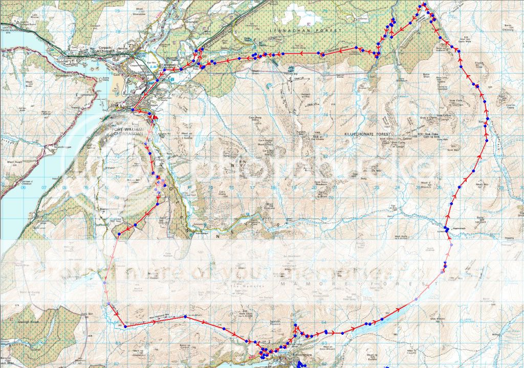 [/IMG]
From Ft Willy there's not a lot of 'day rides' really. You could go up Glen Nevis & past the 3 rope bridge to Luibeilt (push/carry/ride a bit) then either turn right & head back to Kinlochleven & the WHW back to Fort Bill, or turn left & go over the Lairig & back through Leanachan Forest. I've done a complete circular from the youth hostel to the Mamore Hotel via the WHW then past Loch Eilde to Luibeilt then over the Lairig to Leanachen & back to Ft Bill. That was 64 miles but we bothied at Meanachen, over the river from Luibeilt.
Balfa's just shown it!
Haha, congratulations guys, I think its taken four of us to describe exactly the same route, who says STWers don't read one another's posts 😀
would still suggest doing it from spean bridge over the lairig to kinlochleven, descending that landy track to spean bridge having climbed some sublime rocky singletrack from Kinlochleven was galling to say the least!
[i]descending that landy track to spean bridge having climbed some sublime rocky singletrack from Kinlochleven was galling to say the least![/i]
Did you climb from Kinlochleven? We stayed high coming from Fort Bill, went behind the Mamore Hotel. Although we have descended to KL on the WHW a few years ago, that was good!
OK, you've got me, i've never done it as a loop, instead coming at Kinlochleven from Bridge of Orchy and staying overnight, however the climb up from kinlochleven to the hotel was the easiest part of the day, its tarmac! You could possibly cross the blackwater reservoir and follow the pipeline around the hill, something I've wanted to do for a while.
I recognise that map... Since it appears to be in your photobucket account Balfa, I'd appreciate a credit please.
As far as the route goes, clockwise is the best way to go. You get the best of the descents as 13thfloormonk has suggested. It has MANY kms of very rough surfaces so a short-travel full-sus might be the bike for the job. I did it on a hardtail and it shook the flesh from my bones.
Photos here:
http://www.flickr.com/photos/stuartie_c/sets/72157616975641528/
Nice pics StuartieC - I have that pic in front of the bothy of our bikes & me too! 😀 Last year we were a bit dismayed to find a big section of the trail beyond the bothy after the climb up from Corriechoille had been 'excavated' from the nice rocky singletrack footpath, to vehicular wide mud fest 😯 . Bit of a shame that.
I recognise that map... Since it appears to be in your photobucket account Balfa, I'd appreciate a credit please.
I'll gladly take it off if you wish. I had no idea where it came from. I've got a folder full of routes from over the years. Only trying to help. I'm not trying to steal you thunder :-).
You need bigger tyres Stuartie, might i suggest the mighty rubber queens? 😀
Sorry to come across as a grumpy ould bugger Balfa. I don't mind you using it at all. I guess it's technically all Crown Copyright anyway. Neither are you stealing anyone's thunder by offering advice - that's what the forum's all about.
Sorry for being arsey about it.
13FM - what are these "tyres" of which you speak?
Woops!
