
MegaSack DRAW - This year's winner is user - rgwb
We will be in touch
I used the Hope light mount, think it was £7 from CRC.
There's a hole which runs down the middle of the "light-clamp" bit which is perfect in size for the self tapping screws used to mount fans on computers.
I wouldn't trust glue alone with this kind of clamp.
I picked up a Defy+ and flagrantly copied the mount used by Conan257. Couldn't find a suitable screw even with a small mountain of scrap computers to pick through. A small bolt/nut/washer has done the trick though.
Gave it plenty of abuse along the canal and it's holding up fine. I'd still prefer a proper screw on mount but I can't find a thing.
Any OruxMaps users found a cursor that is actually visible?
Managed to pick up a Defy mini at Tescos for £39, have mounted it to the stem using a garmin etrex mount, slightly modified to get a flat platform and used heavy duty velcro to mount a plastic back case for the phone.
Tested it out this afternoon on a 25 mile ride taking in some pretty bumpy tracks and no movement at all.
The heavens opened half way round so also tested how waterproof the phone was, no problem apart from the amount of water on the screen causing it to open up various menus on oruxmaps.
Impressed with the phones GPS as it didnt lose the signal at all, even through some woods.
Result!
My Cases have turned up now, along with a Hope light clamp so I just need to join the 2 together and I should be able to just snap the phone into the hard case and remove it afterwards.
Cheers for the Pics Markgravo, thats what I was thinking but using a phone case instead of the actual phone back.
Glad others are having success. For sure it's not Garmin 8XX, but still serves perfectly well.
Waiting to see if the case option works, I was always worried about a drop/rock/descent knocking it out!
SRAM have just released an adaptor to allow 605/705 to mount to the new quarter turn mounts.
www.wiggle.co.uk/sram-quickview-computer-mount-adaptor/
one of these might be a good way of mounting a phone to a standard Garmin mount. SRAM do a central mount for about 13 quid for the quarter turn GPS's
The cheap back case that I got off the Bay is a very tight fit around the phone, I think the case is more likely to come off the mount before the phone comes out of the case!
link to the case?
Cant get a link at the moment as I am at work, but the item number was 380651028725.
I've finally realised that I don't have the spare cash to go with a Garmin 8* and I think this will provide most of the bang for a lot less buck
Can someone set me straight on the requirements?
A Motorola Defy Mini (other small smart phone would do I guess?)
Does it need to be able to read SIM cards?
A USB connection to download the App (OruxMaps?) - I assume this can be done without SIM?
An SD card to store extra maps
A connector for the bars or stem
Can you carry extra batteries for these phones?
thank you!
Any Android phone will do, the defy mini just happens to be small, cheap and quite robust.
You dont need a SIM as you can download oruxmaps and any offline maps you want using your home wifi, if you have it, the phone just uses GPS when your riding.
You will need an SD card as the offline map files can be quite large and oruxmaps writes to the card, the Defy mini comes with a 2GB card which I have found OK at the moment.
The Defy mini does have a removable battery so you could carry a spare, I have done a couple of 4 hour rides recently with oruxmaps tracking the route and the phones battery has had about 35% left at the end.
There are a few mounting options for the phone as mentioned earlier in the thread.
Hope the above helps.
With no sim in my defy mini, and wifi turned off, I've had it tracking and mapping (using alpine quest) all day one day, and all the next, off a single charge.
It gets pretty epic battery life IME - big battery for the size of screen and CPU.
Conan257 - Member
Glad others are having success. For sure it's not Garmin 8XX, but still serves perfectly well.Waiting to see if the case option works, I was always worried about a drop/rock/descent knocking it out!
I did 3 hours racing at the Summer Enduro last weekend using this to log the route and times on Strava, the case option + Hope light mount works a treat, it holds the phone very securely, and the whole lot survived being flooded by water/Torq mix when I had a Camelback malfunction
I`ll get some pics of it when I get a minute
Yes please for pics. I'll probably move to this if it's suitable as it allows me to leave the mount in place when taking the phone inside for updates/uploads.
Only trouble is I have a hole on the battery cover which will need sorting to stop water getting in...
great thanks - defy on order!
will post some pics once it's working and in place
Excited! 😀
I just thought I'd post back here with my current solution which seems to work pretty well. Today was very sunny and I had no problems reading the display.
I got a rubberised case as discussed earlier in the thread, from ebay for a couple of quid which holds the phone pretty solidly on its own.
I've made a couple of slots in it and am using a velcro pump strap to hold it on the stem. It seems to work pretty well though if I do it up too tight, it bends the case and tends to make the phone pop out. Otherwise (eg I tighten it just enough), it's rock solid in terms of holding the phone and I think I'll just put a small plate of metal between the slots (so that it can't bend if I tighten it up more) then there'll be no chance of me moving it if it hit it with my hand when using it.
[img]  ?nocache=3954[/img]
[url= http://images.everytrail.com/pics/fullsize/6282732-pic_60.jp g" target="_blank"> http://images.everytrail.com/pics/fullsize/6282732-pic_60.jp g"/> ?nocache=1262[/img][/url]
Click this one for full size
Excuse the crap pics, the bike was in the back of the van at the time 🙄
Ebay Phone case, M4 or M5 CSK screw, corresponding Locknut, Hope Light mount from CRC 8)
[URL= http://i6.photobucket.com/albums/y211/cr500dom/IMG_1674.jp g" target="_blank"> http://i6.photobucket.com/albums/y211/cr500dom/IMG_1674.jp g"/> [/IMG][/URL]
[URL= http://i6.photobucket.com/albums/y211/cr500dom/IMG_1676.jp g" target="_blank"> http://i6.photobucket.com/albums/y211/cr500dom/IMG_1676.jp g"/> [/IMG][/URL]
[URL= http://i6.photobucket.com/albums/y211/cr500dom/IMG_1675.jp g" target="_blank"> http://i6.photobucket.com/albums/y211/cr500dom/IMG_1675.jp g"/> [/IMG][/URL]
I got myself a defy mini off eBay with faulty speaker for under £30, had an old reflector bracket, so have bodged it on the bars with that for now, is strong, but currently not removable very easily. I want to try and get a quick release set up with 2 clamps so I can quickly swap it from road bike to mtb.
I've tried mapmyride, and planning to have a look at strava (as it generally sounds more reliable), but would really like to run orux for the os maps, has anybody got any links to easy(as poss) how to guides for android?
I'm fairly I.T. literate but not played about with digital maps much before.
Cheers,
Sam
Oruxmaps has a user guide that covers off the maps...it is a good user guide.
The system is very good, but as I only use it for tracking, I've never seen the screen during operation. App is started, GPS turned on, tracking started and phone in bag on my back. Do ride and once done, remove phone and stop tracking.
100! 🙂
Orux is very easy - To download maps:
- Set the map to the one you want - click the map icon at the top right and then 'switch map' and select the one you want (I've been using Ordnance SM (UK)).
- download the maps for the area you want - click the map icon acgain and then scroll down to 'Map creator'
- Select the area you want and then the tick
- Select the layers you want - the higher the number, the more detailed it is (eg you see a smaller area on the map - smaller scale) - the higher numbers require much more space (since there are more tiles for a given area). You may need to scroll the screen to see this bit
- Give it a name and then click download.
Then in the main view, click the map icon at the top right and then 'switch map' and select the one you want from the 'offline' list.
FWIW, I'm thinking of switching to OSM maps instead of OS - I find that OS is actually a bit too detailed and hard to really read when riding the bike.
Very interesting thread this. On the strength of it I've just bought a second hand experia mini pro which isn't water proof but does have ant+ so I can connect a hrm. all of this comes in a lot cheaper than a bryton etc so thanks guys.
Very interesting thread. I have downloaded Oruxmaps, now trying to get maps. I have tried to follow what clubber says above but I am not getting any maps. It says that it has downloaded tiles and files are created but nothing to view.
What am I doing wrong?
Mike
Yes, got it sorted. Downloaded maps. Does seem to take a while to get a fix on satellites.
Just got my new Defy Mini on ebay - can't wait to start the DIY GPS project!
Is it possible to buy the 1/4 turn male connectors (ala Garmin) so you could use the nice "out front" mounts?
I though it should be possible to screw one of these onto a hard case and then the phone/computer could be used with one of [url= http://www.wiggle.co.uk/sram-quickview-garmin-gpscomputer-mount/ ]these[/url]
[img]  [/img]
[url= http://www.wiggle.co.uk/sram-quickview-computer-mount-adaptor/ ]take this mount[/url]
aradite/screw/etc to phone then should be able to use garmin style mount.
any idea how well or badly a Galaxy ace is likely to fair, granted they are crap phones ime, but they are common, and it should be possible to get one reasonably cheaply on ebay.
That's exactly what I'm going to do - unfortunately the adapters seem to be taking longer to get to stock than planned (it was supposed to be by now).
mrmo - the defy mini has a pretty low spec and mine seems to run fine for what I'm using it for - eg mapping. I've deliberately only loaded what I need on it and turned off syncing, etc and use airplane mode to try and stop anything unnecessary running/using the battery.
Hi Clubber, i re-read the thread after posting (dur) and saw your link - hopefully those adaptors will be in stock soon!
Thanks clubber, just have to trawl the spares and repairs on ebay and try and find a small phone! that android phones keep on getting bigger is annoying when you want a tiny one!
anyone want to strap a Galaxy note on the front?
I dont know if they are still doing them but Tescos had the motorola defy mini sim free for £39 a couple of months back. You had to go in store and they were not on display, I had to ask the chap in the phone section, who was not even aware of the offer, he found one of the phones out back.
Yeah, I think someone on this thread did that 🙂
I'm very interested in doing this for route following on my road bike.
Any one know what the max battery life I could get out of one of these defy mini's with everything bar the GPS turned off and occasional use of the screen when I need to know which way to go?
Is it feasible to use all day for 12h + ?
Also how low rent could you go on the mount. Would some of that fancy velcro combined with a simple plastic plate and some zip ties do the trick.
Also we need a list of the best phones to get for this. I suppose a decent candidate needs to be small, weather/water proof, long battery life, decent GPS chip, ANT+ if possible.
12+ h might be a push - think what most phones will manage... If I was doing that, I'd be using my 'proper' GPS - eg Garmin 605
Mind you, you could take spare batteries given how small and light they are now and if you're not using the screen much, you could certainly extend the life a fair bit.
For the mount, see my pics on the previous page - that cost £3 for the case and whatever a bit of velcro costs. I've now got a nicer one on the go to allow me to mount it further forwards over the stem to be more in my eye line when riding (as set up above, I need to look down to see it properly). I'll try and post pics once I've got it set up properly but basically, it's the Hope light mount with a piece of aluminium to get the position right and then the case bolted on the alumninium, out just above/in front of the stem face plate.
My iPhone has tracked for 9 hours and had a decent amount of juice remaining, it could have done 12 with no bother. Everything was turned off appart from the GPS.
Don't really want to tape my iPhone to my bars though and its not waterproof and this set up would cost about the same as a decent waterproof case for an iPhone.
Would checking the screen every so often drain it that much? How long has anyone else been able to manage?
Agreed that a Garmin would be better but I probably only ride a couple of times a year where I don't know where I'm going and need a GPS at all so can't justify the cost and this would have the additional benefit of being a half decent cycle computer the rest of the time.
mrmo - if it's any help, I have Oruxmaps running on a Samsung Galaxy Europa i5800 and it runs OK. I am looking for a Defy on Ebay at the right price but this is OK for now. I don't attach it to the bike, just set it tracking and put in a pocket.
Assuming the screen is set to turn off after 30s or so of inactivity, I'd say you'd get 12hrs.
The screen is the biggest drain in my experience, and I've have 6 hours of screen-on use.
Be warned, I've tried a couple of different glue related mountings, and after time the glue becomes unstuck. Feel free to experiment though.
My Mount arrangement is looking a little worse for wear after an OTB dismount on Saturday.....
Phone popped out and is fine but the hardshell case has cracked near the mount.
Still works ok but I doubt it`ll survive another one 😆
Ideally it needs a plate or something stiffer between hope mount and Phone case, so that will probably be the next item to make
Oops...
[img]  ?nocache=1676[/img]
The phone came out of the case at 30mph when I hit a bump in the road and then got run over by at least two cars...
Shame as it was all working nicely just before that. Pics below show my latest mount (Hope clamp, section of aluminium to space the case to the middle of the stem and then the case). Anyone seen a cheap defy mini as I think I'll replace it and just use some electrical tape to ensure that it can't come loose...
On the bright side, I guess I'll have a spare battery when I get a replacement 🙂
[img]  ?nocache=4544[/img]
[img]  ?nocache=460[/img]
Ouch - that's annoying! Good looking mount though.
I managed to get a nearly new one from ebay for under £40, yet to do the mount yet but will pay heed to your experience.
What about velcro in the case (hooks) and on the phone (fuzz)?
The case is too close fitting to put anything like velcro in it. I don't intend to take the phone out of the case very often so I don't see an issue with taping it in - just a small amount will be enough I reckon. Or some double sided tape inside the case, probably. The case is really to fit the phone in without drilling a hole in the phone's back cover.
I see - I was hoping to use 2 cases, one on the road bike with a SRAM 1/4 turn thingy and one with a hope clamp.
I guess I can use the 1/4 turn one with other garmin a-like mounts for the other bikes, and keep the other case for spares.
I'm still thinking of going the garmin quarter turn way - because I have a Garmin 605 which I use for longer rides due to the longer battery life though from a few posts ago, maybe that's actually not an issue with the defy. I haven't really run long enough to be sure.
I've had a 6 hour ride out of mine with the screen on the whole time. Might not do much longer than that though.
My hope mount is permanently attached to the battery cover of the phone, one flick of the switch and it can transfer to another bike without issue. I wouldn't get too hung up on the garmin mount unless you're REALLY keen.
I think screwing the garmin mount onto the battery cover will be a good way to get what i'm after. Just need the things to get in stock!
Anyone want 2 defy hard cases? 😕
I've got two spare too 🙂
Clubber have you tried Tescos ?
Mine was £38 from there brand new
Cable tie should stop it bouncing out ;o)
Yeah, I'm going to give that a go
Might as well post my own solution here for anyone that is interested:
Ultimate Mobiles case (waterproof and fairly bash proof):
[img]  [/img]
http://www.amazon.co.uk/dp/B0057FJ41Y
[i]Customised[/i] with some Araldite to remove the rotation option (I never need landscape) and the rattly quick-release option. 🙂
For long rides (4hr+) where phone battery life might become an issue then I have a very short (20cm) right-angled USB lead (from ebay) that runs from the case:
[img] 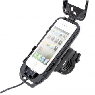 [/img]
to a top-tube mounted tri bag:
[img]  ?w=350&h=350&a=7[/img]
http://www.wiggle.co.uk/topeak-tri-bag-with-rain-cover/
which holds an external battery pack like this in the side pocket:
[img] 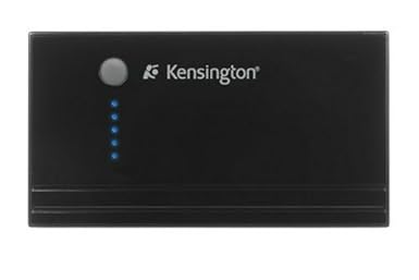 [/img]
Bit chuncky Graham but looks good otherwise.
Has anyone seen any good deals online on a Defy mini (or Defy +) - I can't get to Tesco at the mo (And I have a feeling I checked before and they didn't have any) and I haven't had a lot of luck finding a mini...
Yeah the case/mount isn't perfect. It was secure, but a bit too wobbly before I Araldited it. And the clamp is too small for road bars so needed 'modified' too.
But it does hold the phone in a nice silicon cushion, all the physical buttons and ports are still accessible, and it is waterproof enough that I use it in the pouring rain without any concern (less of an issue for the Defy users obviously).
BTW there was a new release (v21) of MotionX GPS the other day (on iPhone at least not sure about 'droid) - good new feature which I tested this morning is the "Jumbo display" which lets you have 3 selectable readouts take up the whole display (e.g. speed, distance, time) - ideal when you just want an easy-to-glance-at "cycle computer" type view when you are not actively navigating.
Oddly MotionX doesn't seem to exist on Android...
Hmm... neither it does. That's crap. I wonder why?
Small company, resources to develop only one platform I'd guess...
out of interest i dug an old Blackberry i have kicking around in a draw, Discovered that you can get endomondo for it.
Turned it on and have left it running all day, after 13hours i discovered i still about have a half charge on the battery. Will have to try it on a long ride and see what happens. Screen is a bit small but might work, Just have to do some investigation about the settings.
In Endomondo there is a "Low Power Mode" tucked away in the options.
This stops it doing the live tracking stuff to save battery.
Not exactly the same, but a cool bit of tech. I got one of these a few days ago. Put a sim in it, phone it from a mobile and get a text back with the GPS location. Normally used for tracking cars and partners, but also good for tracking team mates on 24 hr races. (It's a TK-102)
[img] ![]() [/img]
[/img]
No defy minis in my local big tesco...
Try ebay for a standard defy. Its water resistant, faster (not that it really makes a difference) and its smaller (but only just),
Weren't the original defys really slow though?
Thanks for the suggestion though I'll go and compare the specs
i cannot seem to get Oruxmaps to show google maps when the GPS finally gives a proper signal to my liocation, i press the top right icon "map" and then select google maps. im on wifi.
any help?
Works ok for me and I've done the same as you...
As a follow up, I have a replacement Defy Mini (see above...) and with a half width bit of electrical tape at top and bottom to hold the phone in the case, it's now holding - I rode some very bumpy roads this morning with no issues.
I'm still experimenting with the maps though - OS maps are actually too detailed at the zoom level I want - I ideally want something like on my Garmin.
I have been interested (in a geek sort of way) in trying to write an app so I am considering just creating my own bike computer/mapping app. If I do, it'll be android only but I'd be happy to share it for some testing.
got the maps working now thanks, was Works wifi having issues.
Is there some online mapping tool i can use to generate trails,
the little Defy screen is tricky to make trails on....?
MapMyRide doesnt export the right format does it?
I use bikehike to plot routes and find it best to save them as a kml file.
How can I get this route:
Into Orux maps ?
Its the Tour De Broads sportive I`m doing next weekend and it would be useful to have the gps to follow ?
Hi, Once you have downloaded it, connect your phone to your PC and copy the kml file into the Oruxmaps tracklogs folder.
Then you can open the route in Oruxmaps.
Thank you, I'll try that tomorrow 😉
Well I bit the bullet and tried this myself. I managed to pick up a Samsung Galaxy Y for a bargain £18 from ebay, bought an SRAM 'out front' mount and the male adaptor to fit.
I cut off the excess from the male adaptor and araldited it to the back of the phone case. Here's the results. Took it for a quick spin and looks like it will do just the job. I'm running IPBike for Android.
[img]  [/img]
[img]  [/img]
This thread has inspired me to go down this road to produce a garmin-a-like.
I'm really struggling with the maps though, i can't see a OS (UK) option in the online list. Is there anywhere else to get hold of these, the standard maps don't have the trails I'm interested in.
Thanks
Matt
Went to create an OS map on oruxmaps today and can't see the option for os maps in the list, anyone else have this problem?
Previously it was there at 25k
The latest updates to Oruxmaps had some comment about certain map sources being removed 'for legal reason' or suchlike, so I assume that is the reason. You may be able to roll back to the earlier version if you can find the apk installer somewhere on the web.
Is there an iOS equivalent to oruxmaps?
I'm sure there will be, sorry, not fashionable enough to be able to tell you what though 😉
Ref Oruxmaps and the removal of OS maps, see this thread:
http://singletrackworld.com/forum/topic/orux-maps-question
If anyone does need the previous version of Orux maps that has the OS maps built in, I could upload it somewhere though you don't need it to still get OS maps:
1. Download OS mapping using an old version and then upgrade (which is easy enough as you can keep a backup of the old and new apps one your phone)
2. Download on the computer and transfer to the mobile.
3. Revert to the old version (which works fine) and just stick with that.
if anyone is using the Defy+ and wants to root it easily 😉
http://forum.xda-developers.com/showthread.php?p=37508806
Top post I'm getting in on this when I have time to assimilate it. Bed now
got one of these as i had run out of coathangers and gaffa tape...
For iOS I use Galileo, and MOBAC to get the maps (as I also use it for AlpineQuest on android)
Defy has no power button on front to wake so while mounted in a protective case I had to leave it on high brightness without the screen timeout, seemed a bit of a waste.
this [url= http://www.rubberbigpepper.com/en/node/365 ]handy little app[/url] will adust the display brightness with a touch slider on the screen, I found it easy to use while riding along 🙂
[img] https://lh3.ggpht.com/dDdfF1Q7AQ6GgLxZo4cv7rafAtZIh5NpLf4UTH_nUSD5PlEdMGJXMe1wNjh2-UN5-R4=h900 [/img]
http://www.rubberbigpepper.com
Nice, like it!
Not using a case so don't have this 1st world problem... However I can see it's use to play with brightness etc to save battery power.
Just seen this thread and will read through it later.
For the record, I ended up with a spare Orange Monte Carlo which has 4.5" screen. Some phone functions didn't work, so didn't want to sell. Ended up converting it into a GPS device, wiping a lot of the Orange cr@p and loading Back Country Navigator @£6.99 which includes full uk 1:25K OS maping. Works a treat, only downside is the screen has always been a bit useless in bright sunlight.
Just in case anyone copies me, thought I'd do an update. Rode my CX bike at the weekend with the mount as pictured. Half way round, the phone and case broke off the mount - the case plastic had just snapped where the bolt goes through 😯
Luckily I have a garmin 605/705 adapter on the way and a spare case so I'll be fixing them together which I'm confident will be more robust...
[img] ?nocache=4544[/img]
[img] ?nocache=460[/img]
Clubber, Mine did the same after a couple of OTB dismounts
Whats the Garmin solution you are going for next ?
I was going to do a plate to attach to the Hope mount, and then bond the phone case to the plate and see if that is any better !!
But a Garmin type mount to be able to use the out front mounts would be great