Forum menu
Does anyone know who the 'calderdale flood aid' folk are? Just heard them on Radio Leeds asking for stuff, including logs, which I've got a car-full I'm happy to give away, but am not on Facebook and don't know where to deliver to.
(Yes, they're seasoned!)
I can check on FB and get back to you.
Cheers, Clover.
Bear, have a wee gander at;
http://www.cffc.co.uk (a pre-existing organisation, but mentioned on the FB page)
And;
http://caldervalleyfloods2015.weebly.com
Cheers Mr Pie, that second link has a load of drop-off points listed. No mention of logs as a wanted item though, so may just ring & check before dumping a small forest on them 🙂
No worries.
That was my one helpful post of 2016, I'm back to being a twunt now 😀
It definitely suits you better 🙂
I've emailed you bearnecessities
[url= http://www.independent.co.uk/news/uk/home-news/uk-flooding-how-a-yorkshire-flood-blackspot-worked-with-nature-to-stay-dry-a6794286.html ]Interesting article about Pickering flood defences[/url]
I was just about to post that too Trout, saw it via Twitter.
Went out today round Lancaster. Up by Gressingham is [url= https://www.google.co.uk/maps/ @54.1218695,-2.6425645,3a,75y,100.78h,84.11t/data=!3m7!1e1!3m5!1sydwpRxZWfoq5Ikrx5FuxMQ!2e0!6s%2F%2Fgeo1.ggpht.com%2Fcbk%3Fpanoid%3DydwpRxZWfoq5Ikrx5FuxMQ%26output%3Dthumbnail%26cb_client%3Dmaps_sv.tactile.gps%26thumb%3D2%26w%3D203%26h%3D100%26yaw%3D40.48465%26pitch%3D0!7i13312!8i6656]this bridge[/url] which is now closed due to flood damage.
The fields either side are flood plains and I've seen them flooded before and the vegetation caught up in the fencelines but this went way beyond what I've seen in the past. The waters had receded but the bridge is badly damaged (buttresses crumbled) and there are branches and vegetation spread round the hedgerows for 200m either side of the bridge indicating how high the waters came. The walls you can see on that streetview link above have crumbled completely.
Not sure the Pickering defences have had a real test. NYM have got off pretty lightly in terms of rainfall compared with NW and Cumbria so far.
I agree with the general principle behind it though. Time for a rethink of upland management.
Crazy legs, can you confirm that bridge is actually damaged? The road has collapsed just on the other (Hornby) side due to a burst water main so that would probably cause a road closure anyway (assuming it hasn't been fixed yet, it was a few weeks ago that it happened).
Yep, properly closed off with plastic barriers and then wire ones tied into it further down. You can get onto the shore on the eastern side of the bridge and see how damaged the bridge buttresses are on the upstream side. There was another rider there who said there was a big tree got lodged against it. I'd have taken pictures if it hadn't been pouring with rain, it was too wet to get my phone out.
I'll be honest - pedestrians and cyclists can get through it (it's obvious that people have been using it) but there are signs warning that it is strictly no access to anyone and you certainly won't get a car past the barriers.
I'd guess that trying to use it on a weekday when they're working on it will simply result in you being turned round but there was no-one there this morning.
Hornby side all looked fine. I came in through the village itself heading north up the main road then the left fork to Gressingham.
Thanks, last time I was in Hornby we had a look but only as far as the burst main which seems like a fairly simple job (well the main was already fixed, the road surface was still caved in). This sounds like it will be a bigger job!
Time for a rethink of upland management.
Thing is, we keep hearing from 'certain drum-beating p, self promoting authors' how it's all down to moorland drainage, but (aside the fact that gamekeepers are actually the ones who have been the proponents of blocking grips for some years now) the people who actually do the science on this are saying there is little actual evidence to support the theory that it makes rivers less flashy, and the people running experiments on catchment management and blocking brains are not yet finding it.
As for the 'trees are the answer' argument - an unfortunate fact that anyone who has planted trees in upland areas will tell you is that digging shiny fresh NEW drains is often an essential part of getting trees to actually grow on the exact same shitty soils that they want to colonise with trees,
Holy cow, the entire north east (and East it seems) of Scotland is in a bad way. There's standing water and flooding just about everywhere.
Maybe it's just as well it's too dark to see how high the rivers getting....
Yeh, got an email today from a club mate unsure he'll be able to get from Blairgowrie to Dundee.
the people who actually do the science on this are saying there is little actual evidence to support the theory that it makes rivers less flashy, and the people running experiments on catchment management and blocking brains are not yet finding it.
That's odd, I sat in a building where a lot of that research was being carried out for nearly 10 years. That's not their conclusion.
It might be if you just want to cherry pick very small aspects, a la climate denialism, but if you understood the research in context (and weren't so rabidly anti-anything-remotely-associated-with-the-left), you'd probably not be making those comments, as they make you look rather foolish.
Cumbria is getting another soaking. 🙁
[img] 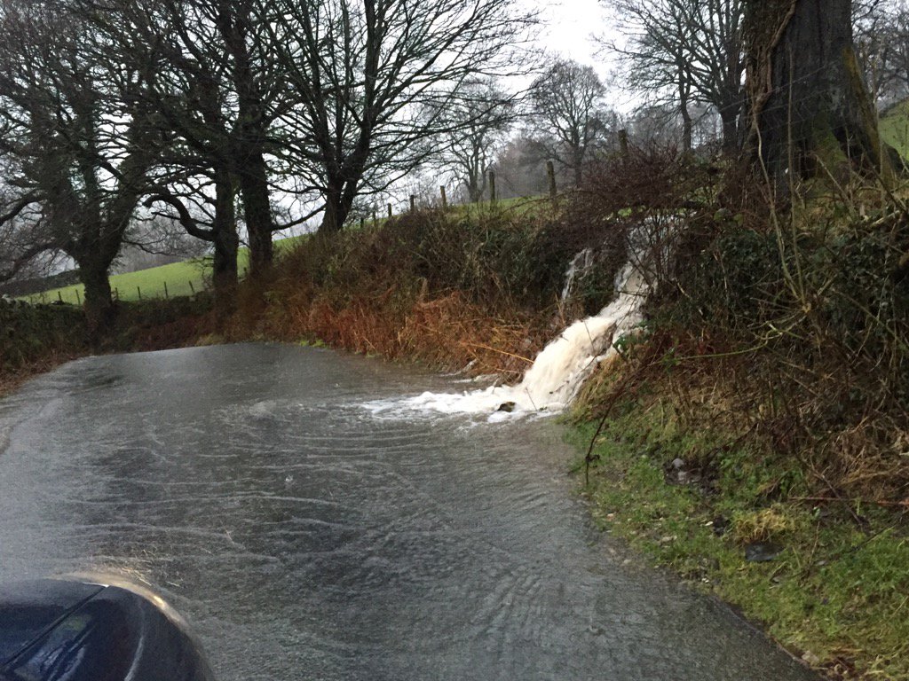 :large[/img]
[img] 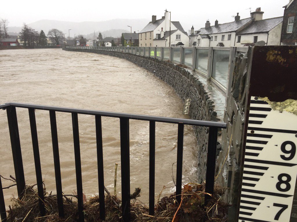 :large[/img]
That's the Greta in Keswick which has apparently risen a metre in an hour.
Main body of rain is just clearing off the Lakes now, so hopefully things will be fine this time around.
Glenridding Hotel is flooding again according to their Facebook page - not sure how badly. 🙁
River in Ambleside is not far off the bridge here either:
Anyone know where we can get a cheap, second hand bailey bridge..?
Maybe the public money spent on protecting the private residence at Abergeldie Castle would have been better spent here.
Kids sent home at lunch today - Keswick/Whinlatter area. Looks like a false alarm as it's stopped chucking it down and there's not much of a lag time on local rivers.
Looks like a false alarm as it's stopped chucking it down and there's not much of a lag time on local rivers.
A66 has been shut all night, Glenridding Hotel is flooded AGAIN (4th time now since Boxing Day) and water is all over the road at Rydal, back of Ambleside again. Some photos and video on the I Love The Lake District Facebook page.
From the rain radar, they had a proper deluge through the night. There's another band of heavy rain over north Wales moving NE at the moment...
Another lovely old [url= http://lm.facebook.com/l.php?u=http%3A%2F%2Fwww.cumbriacrack.com%2F2016%2F01%2F27%2Fhistoric-cumbrian-bridge-collapses%2F&h=gAQHNRGv5&enc=AZPWIJRBtD6aVzCebeKUP7tax-B9wPNoxWzJz0bA1wZMgfxbUMhyHuzfPZpiHFwO5h4weptb-Cg4d4FT8xoukIuorNXRsgCHltF_q2x91LjNrlJHWCPU85Vqtpj3furiw_k1EjpORS6H9XSsJjON45B4&s=1 ]bridge[/url] gone. 🙁