UPDATE: CLASSIFIEDS section refreshed, redesigned, searchable: Go take a look
Looking to do some more "proper" rides this year and I've still never ridden in the Peaks. Would like some suggestions for decent loops for around 2-3hrs, my fitness still isn't great so easier climbs are preferable at the minute 🙂 I'm more into fast flowy singletrack descents than rocky/techy, though good to have a bit of both (bearing in mind I'm on a hardtail too)!
Would be grateful for any suggestions and gpx or komoot routes to help navigate!
Hayfield loop dude. MTBR ran this route as one of their many 'pull-out' route guides oh, around 18 years ago 🤣 It's bloody brilliant and has literally everything you are looking for. I can get around it in about 1 1/2 hours, but that's because I'm da awesumz 😎
No, seriously it would be a great ride to do at a normal pace in 2-3 hours. Since I'm a cheapskate and can't upload an image of this route I'll have to do my best to describe it.
1) Park near the Kinder Scott reservoir Here - [Paste this into Google Maps]: 53°23'19.9"N 1°55'20.9"W
2) You want to be heading up a section of bridleway that leaves from here climbing steeply up over the moor below Kinder scout.
3) Follow a sweet section of flowy bridleway north and you eventually pop out on the A624
4) Proceed south on A264 for a little way and pick up Lanehead road (on your right)
5) Eventually you'll see a bridleway on the left that takes you up and over Lantern Pike (take the right fork option of two)
6) This will go around Latern Pike and eventually pop out onto a track / road that crosses Sitch Lane
7) Follow in this general direction to another track/road that leads to a steep bridleway down towards Sett Valley Cafe
8) From here you want to head briefly on the road back towards Hayfield - and pick up Mortland road on your right - which turns into a trackway up Chiley Churn hill (from memory I think you would be heading towards a radio mast at the top of the hill on this climb).
9) Pick up a steep bridleway descent on the left near the top of this hill that leads to Phoside farm
10) This will drop you out on the A624 south of Hayfield - from here you can find your way back to the car - of if you are feeling really adventurous - add on another loop over one of the surrounding hills.
I haven't ridden this route in something like 15 years, but it was one of my absolute favourites - some sweeet descents and peachy singletrack.
Failing this - have a nosey around Hope Valley, Hathersage area - The Beast descent and Mam Tor descent are also pretty good.
Best wishes from NZ
p.s. Its "The Peak", not "Peaks", as the name is derived from the Pecsætan people who once inhabited this region.
If you are coming from Manchester the Hayfield loop is perfect.
If you are coming from Sheffield, parking near the fox house and doing a loop involving cut gate is great. I'm on a train in India so I'll not delve deeper.
Another great option from either is getting the train and then doing a non-loop ride..
Hayfield loop dude. MTBR ran this route as one of their many 'pull-out' route guides oh, around 18 years ago 🤣 It's bloody brilliant and has literally everything you are looking for. I can get around it in about 1 1/2 hours, but that's because I'm da awesumz 😎
No, seriously it would be a great ride to do at a normal pace in 2-3 hours. Since I'm a cheapskate and can't upload an image of this route I'll have to do my best to describe it.
1) Park near the Kinder Scott reservoir Here - [Paste this into Google Maps]: 53°23'19.9"N 1°55'20.9"W
2) You want to be heading up a section of bridleway that leaves from here climbing steeply up over the moor below Kinder scout.
3) Follow a sweet section of flowy bridleway north and you eventually pop out on the A624
4) Proceed south on A264 for a little way and pick up Lanehead road (on your right)
5) Eventually you'll see a bridleway on the left that takes you up and over Lantern Pike (take the right fork option of two)
6) This will go around Latern Pike and eventually pop out onto a track / road that crosses Sitch Lane
7) Follow in this general direction to another track/road that leads to a steep bridleway down towards Sett Valley Cafe
8) From here you want to head briefly on the road back towards Hayfield - and pick up Mortland road on your right - which turns into a trackway up Chiley Churn hill (from memory I think you would be heading towards a radio mast at the top of the hill on this climb).
9) Pick up a steep bridleway descent on the left near the top of this hill that leads to Phoside farm
10) This will drop you out on the A624 south of Hayfield - from here you can find your way back to the car - of if you are feeling really adventurous - add on another loop over one of the surrounding hills.
I haven't ridden this route in something like 15 years, but it was one of my absolute favourites - some sweeet descents and peachy singletrack.
Failing this - have a nosey around Hope Valley, Hathersage area - The Beast descent and Mam Tor descent are also pretty good.
Best wishes from NZ
p.s. Its "The Peak", not "Peaks", as the name is derived from the Pecsætan people who once inhabited this region.
If it's the same place I'm thinking of, access from Lanehead Road to the bridleway (Pennine Bridleway) is blocked by a new landowner as the status of the connection is in dispute. There is another way on to the bridleway that involves either heading north up the A624 instead of south then turning down Monks Road to join the bridleway or following a cheeky section of permissive footpath that is broadly parallel to the A624 before following Monks Road.
More rolling and less rocky tech makes me think you might be happier starting out in the White Peak. Vertebrate Books do a guide to the area which is worth having.
What side of the Peak are you on? I'm on the east side and the Hayfield loop is over an hour's drive from me.
Also, how do you park at Fox House and ride Cut Gate? Not 2 places I'd usually put together.
I put this together for a ride a couple of years ago with my sons on a trip there. More rocky than singletrack and the last bit round Howden is part road / easy double track. We skipped the Edale dog leg by starting at the Ladybower visitor centre so Mrs g-d could dog walk.
https://explore.osmaps.com/route/17902403/Edale-Derwent-Howden-Ladybower
Two of us on hardtails (the kids funnily enough 🤣 )
Da peakz, originally named after a roving gang of weathered Pindale cement workers who roamed da valleyz using hard hats as weapons, doesn't go with easy climbs.
As mentioned the White peak would be a bit more chilled and their are some tidy routes around Black rock and Ambergate.
What side of the Peak are you on? I'm on the east side and the Hayfield loop is over an hour's drive from me.
Also, how do you park at Fox House and ride Cut Gate? Not 2 places I'd usually put together.
I'm coming from the East Midlands (Northants) so something towards the south of the area might be better for less time in the car. Probably should have mentioned this to begin with!
I usually go over to Long Mynd when I want to do a non-trail centre ride, but fancy trying something new.
You could do Cut Gate from Fox House. But it you can do it in 3 hours then you’ll probably get a stripey jumper one day
White peak is brilliant for what you describes. It just needs to dry out first. So if you plan to ride in the summer i recommend this. It’s a combination of 2 loops from the book. You could easily shorten it
https://strava.app.link/lBiHvxEMlRb
The dark peak is much more resistance to rain
This is very melow and could be started from Fox House. I think i must have met my wife for lunch, that would explain it not being a loop
https://strava.app.link/kTxCy6ZMlRb
Peak district local here. As above the Dark Peak is much more resilient to water than the White Peak. I'm based on the edge of the White Peak and it's properly wet here ATM. I'm hoping that the forecast sun will dry things out fairly quickly. If you want a White Peak loop that is fairly resilient to rain I'd recommend that second loop from ampthill.
One of my favourites is this loop and it holds up reasonably well to the wet weather apart from a massive boggy puddle halfway along Curbar Edge. Lovely views across Curbar if the weather is nice, which it looks to be this weekend. You can extend it with Apthill's second route by stricking out from Longshaw, along Houndkirk Moor to Lady Cannings, then a bit of road work to Burbage Brook and follow the trail back to Longshaw and continue on your way.
Excellent Coffee/Cake/Sausage Roll stop at Curbar Gap carpark at the weekend. Other options are NT tea room at Longshaw or there are always a few vans, think one does Thai, at the layby at Burbage Brook. Oh and if you fancy a pint then the Grouse Inn is good for a beer.
The V-Publishing Peak District guidebooks are a pretty good selection of classic Peak routes complete with OS mappery. Worth a buy imo and available from the nice people at 18 Bikes in Hope as well as online etc. There's a Dark Peak and a White Peak one, as above, the Dark Peak is more resilient to rain in the sense that it turns into a mix of rockery and sludge than the White - more southern - bit, which has more a a tendency to actual mud.
I know books are a bit out of fashion these days, but I think the V-P stuff is worth the price if you're considering regular visits.
https://www.adventurebooks.com/collections/mountain-biking-guidebooks
More rolling and less rocky tech makes me think you might be happier starting out in the White Peak. Vertebrate Books do a guide to the area which is worth having
I have the dark and white peak books from vertebrae and they are great.
Better with a GPS track plotted to stop endlessly taking the book about and Tring to work out which if the two faint paths I was after.
But excellent
There's a classic route named Hope figure 8 or similar from years ago that I love. Start at Hope, up to Hope Cross, then you have the choice of The Beast to your right or Potato Alley straight ahead. Up Rowlee farm, down Mad Mile to Ladybower and come back up , eventually down Hagg Farm and back up to Hope Cross.
time may have dulled my memory, and more capable bikes may have dulled the fun of many of the descents.
I've also enjoyed loops starting at Edale and I particularly enjoyed the drop down at Pindale, coming out near Castleton.
There's a classic route named Hope figure 8 or similar from years ago that I love. Start at Hope, up to Hope Cross, then you have the choice of The Beast to your right or Potato Alley straight ahead. Up Rowlee farm, down Mad Mile to Ladybower and come back up , eventually down Hagg Farm and back up to Hope Cross.
That's my go to Hope/Ladybower ride, except it WOULD have been Lockerbrook rather than Mad Mile. With Lockerbrook now ruined to the point it's not even worth riding, is the Mad Mile any good (think I went down it once about a hundred years ago and don't remember it being anything special)
No screaming mile is nothing special as a descent. Best way down to the res I find is the footpath that goes through the woods behind the outdoor pursuits centre. Go past Locker brook fm as if you are doing the descent and turn right onto the fp at the top of the next rise
Thanks for all the suggestions 🙂 just got to find a free day with ok weather to get out and explore some of them. Have watched a few YouTube vids and the white peak side definitely looks more my kind of thing at the minute, the rockier techy mech smashing trails don't look like my idea of fun!
Peak district local here. As above the Dark Peak is much more resilient to water than the White Peak. I'm based on the edge of the White Peak and it's properly wet here ATM. I'm hoping that the forecast sun will dry things out fairly quickly. If you want a White Peak loop that is fairly resilient to rain I'd recommend that second loop from ampthill.
One of my favourites is this loop and it holds up reasonably well to the wet weather apart from a massive boggy puddle halfway along Curbar Edge. Lovely views across Curbar if the weather is nice, which it looks to be this weekend. You can extend it with Apthill's second route by stricking out from Longshaw, along Houndkirk Moor to Lady Cannings, then a bit of road work to Burbage Brook and follow the trail back to Longshaw and continue on your way.
Excellent Coffee/Cake/Sausage Roll stop at Curbar Gap carpark at the weekend. Other options are NT tea room at Longshaw or there are always a few vans, think one does Thai, at the layby at Burbage Brook. Oh and if you fancy a pint then the Grouse Inn is good for a beer.
Bumping this year old thread as I think I'm finally going to make the effort to go up to ride somewhere in the Peak District this weekend! Just can't decide on a route but this one seems alright as a start - it looks very flat and fairly short though (my usual rides at Woburn have more elevation gain according to Strava). If I can extend to do the Lady Cannings stuff then maybe that's a good shout!
Any other suggestions for this weekend? Thinking it would be good to try and do something that takes advantage of the dry weather whilst I can, so somewhere that's usually a bog the rest of the year might be a good call.
If I can extend to do the Lady Cannings stuff then maybe that's a good shout!
I'd be more inclined to spend some time doing a few runs round Blacka/Devils Elbow/Bole Hill than trecking across Houndkirk just to do LC. Or if you are heading that way, extend it to add a Stanage Edge/Plantation loop
If I can extend to do the Lady Cannings stuff then maybe that's a good shout!
I'd be more inclined to spend some time doing a few runs round Blacka/Devils Elbow/Bole Hill than trecking across Houndkirk just to do LC. Or if you are heading that way, extend it to add a Stanage Edge/Plantation loop
Oh yeah that looks like a plan! Which way is best to go round Devils Elbow? I'm just looking at Trailforks which appears to show the direction going clockwise/west to east on the map.
Afkastr +1
Double post
Which way is best to go round Devils Elbow?
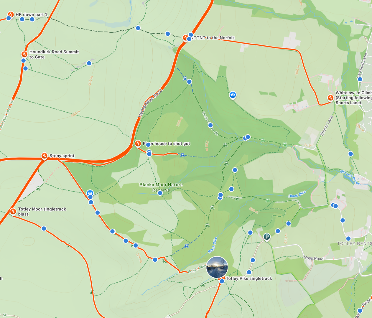
Strava bein a pain and not showing segments unless I zoom in, but from the car park near where its says stony sprint, follow Black moor next to Hathersage Road and turn right down Devils. There are numerous ways back up, a ride/push up Piper House, or the easier (but long road slog) up Whitelow Lane. There are lots of decent runs in the dark green area though - Bolehill DH, Rooty Tooty, Johns mums Knight mare, Roger Rabbit's rampant racecourse a bit further down below Totley Pike singleterack.
I don't really know the best way round tbh, we normally just follow our noses
somewhere that's usually a bog the rest of the year might be a good call.
It would be kind of perfect for an out and back over Cut Gate. It's what I would be doing this morning starting from Langsett if my right foot wasn't in a state of ouch. Not that it's quite its former boggy self these days anyway.
somewhere that's usually a bog the rest of the year might be a good call.
It would be kind of perfect for an out and back over Cut Gate. It's what I would be doing this morning starting from Langsett if my right foot wasn't in a state of ouch. Not that it's quite its former boggy self these days anyway.
I thought it might be ideal conditions for Cut Gate, but I'm not sure if the route actually looks fun or not 😂 looks like it might be a bit of a bumpy slog on a hardtail.
Devils Elbow descent looks really good!
Regarding Blacka, I'd personally do both Devils Elbow and Piper House, with the climb up Whitelow being the easiest way back around. Devils is a really good descent but it's more lumpy than anything on the Cutgate ride.
I can sort you a gpx if you want?
Right at the bench at the top of Piper House is also a nice bit of singletrack to the “other” bench and can then loop right up to the car park on Stony Ridge on easy trails and grassy fields.
Regarding Blacka, I'd personally do both Devils Elbow and Piper House, with the climb up Whitelow being the easiest way back around. Devils is a really good descent but it's more lumpy than anything on the Cutgate ride.
I can sort you a gpx if you want?
I don't mind lumpy going down, it's when it's lumpy up and along and I'm trying to pedal I'm not a fan!
Thanks for the gpx offer, I think I can just about figure it out between komoot and Trailforks!