Forum Replies Created
-
Using an eSIM To Stay Connected In Remote Locations While Hiking Or Biking
-
 Steve_BFull MemberPosted 7 years ago
Watched this on catch-up. Certainly he couldn’t be accused of making this one for the Welsh Tourist Board with continuous rain and no views. Got to admire his enthusiasm tho thought the guy on the gravity bike was the best bit. Found this little clip Making extreme wales The moke certainly puts a different angle on electric bikes!
Steve_BFull MemberPosted 7 years agoChecks back up thread – yep def answered this on 3rd post :wink:
Sounds like you are doing well though.
Steve_BFull MemberPosted 7 years agoIn my case I received confirmation that they had written to the surgeon after a couple of weeks and then a further letter saying the surgeon has not yet responded after 4 weeks. Still waiting and a further 3 weeks have gone by. In fairness the delay might the surgeon not the DVLA. I imagine he/she might have more to worry about.
Ii is my interpretation of the info on their site that if you have been passed by your surgeon as fit to drive then you can drive whilst awaiting their decision. Even then only you can decide if you are ready/fit though!
There is also a document Assessing Fitness to Drive on their website. I phoned them to clarify and they said I had to complete the form or they would suspend my licence!
Steve_BFull MemberPosted 7 years agoWelcome to the world of 21st century procurement – with Edinburgh Schools and defects at Dumfries Leisure Centre etc what chance does a path have :?
Again well done to BofA lads. And to Beagy takes a big man and all that :twisted:
(Just off to have my head scanned to see if I do have a brain :-) )
Steve_BFull MemberPosted 7 years agoCongrats to TF, Callum, Crispin et all for obtaining a review period on this.
Curiously this months Scottish Mountaineer has an article on “sensitive” footpath building though the work is paid for by crowdfunding by MCofS/BMC and I suspect the tender package is largely based on this standard.It is (reasonably) well accepted locally (including the LA) that this is a popular mtb route and I agree with TFs comments but it is hard to see were equivalent funding would come from to provide a separate mountain bike route though something the whole way down to Bridge of Allan would be a fantastic facility for the youngsters or at least those younger than old grumps like me.
Nice blog by the way TF – beautiful mountain photographs.
Steve_BFull MemberPosted 7 years agoSorry to hear about your difficulties OP. It does sound like you have been mis-sold an opt out or misunderstood the explanation. Either way it is a difficult case to argue on a charge back. Have Maggiore actually said this amount is for excess insurance. Did you read theirFAQ before raising a dispute https://www.maggiore.it/en/faq/faq.html They state a refund time which is already long. If you are already disputing before this period you will have confused a possible refund.
We have always booked through a third party online and gone with an annual excess policy. I have never heard the question about excess framed as you put it though we tend to go for a mid price on the rental options. Maybe they are better I don’t know. At the end of the day these are businesses trying to attract customers not have scam against every review.
If you don’t take their insurance you still need to hand over your card and they retain the full excess amount, ie you need enough credit on the card to cover the full excess. It is only charged if they claim damage and you have to then reclaim from insurer. If you don’t take their insurance and something goes wrong there is going to be hassle somewhere along the line.
Indeed with Avis, Europcar and the like the experience (bar queues) is very slick. We recently returned from Portugal and cannot be happier with Europcar drop off at Porto. We read all the “scam” reviews on Portugal and realise how few people do any research before going abroad.
That said they will always try to upsell – special upgrade price/ excess/ satnav etc but have never had any hassle turning it down.
One thing I would say is the annual insurance is worth it even if you take the hire companies insurance – or at least insurance4carhire if not just for the Text HELP for English assistance option :-) also for any bits you discover even the car hire still don’t cover,
Steve_BFull MemberPosted 7 years agoDid this from Glomel
https://www.cirkwi.com/fr/circuit/14089-glomel-circuit-vttMainly scenic but some nice stuff either side of canal
Supposed to be some around Finistiere
http://www.finisterebrittany.com/discover/mountain-bikingFrench routes tend to be tours with a bit of interesting stuff thrown in. And sign can vary from excellent to non existent
Steve_BFull MemberPosted 7 years agoFeel your nervousness! Borderline cataract but MRI has now changed to a different diagnosis – I see specialist on Wed so trying remain optimistic. Dad had the cataract and was over the moon. I am assured the cataract is now much more straightforward than it used to be :-)
Steve_BFull MemberPosted 7 years agoJust seen this and recognise that smile from the 20 mile mark, Donation made. I was shattered just doing the supporting :?
Hope you made it round Stevemuzzy – I know your name thru Ally but wouldn’t recognise you.
Steve_BFull MemberPosted 7 years agoAs above Picasa works fine in W10. The W10 photos app has also been much improved and is good for simple editing.
Steve_BFull MemberPosted 7 years agoI have used an app called IPhiGenie Also on Android. It is a lot cleaner than the IGN website linked above and gives the same mapping.
It gives quite detailed road mapping for free and a weeks free trial for all mapping. (Or you can purchase app for £5.99 and pay £4.49/ month use – tho needs to be cancelled) The free version will cache for off-line use for the trial week. We managed a 2 week holiday on the free detailed mapping (2 phones).
Viewranger allows IGN road mapping as a free overview and tiles can be purchased – or free OpenCycleMap tiles can be cached
Used above with Maps.me and some offline google areas for all our navigation.
Steve_BFull MemberPosted 8 years agoW10 will pop up a notification when you insert a memory card asking you how you wish to import photos. If you don’t catch the pop up the action should be in the action(notification) centre
My wife uses Picasa so that comes up as one of the options. The default will prob be photo
Steve_BFull MemberPosted 8 years agoHi Craig. You have had a bit of a time of it :-(
Two words. Alan Hay!
Although it may be hard to get hold of him as he is winding down. I am really not sure what to do when he gives up altogether. (and he will charge about £30 not £250!) He will deal with issues arising from poor posture/compensatory muscle use etc.Worth a chat with him anyway.
The NHS physios in Stirling are v good – at least the ones Alison and I have seen. Maybe cos they are used to encountering crocked mountainbikers – so insist on an appointment with them.
Stirling doesn’t really over the best easy recovery trails – maybe accept that regular circuits of Callander Trails might be better at the mo than hauling yourself up Dumyat.
PS our doc issues Naproxen with a large dosage of gastro protecting tablets so as TJ says it may well be worse than Ibu. We don’t find it particularly good as an anti inflam, so I guess its a personal thing. We used to swear by Diclomax but the doc wont issue it anymore – apparently it is responsible for ulcers and internal bleeding! Safer mountainbiking.
Steve_BFull MemberPosted 8 years agoWe had some brilliant biking from Brecon. There were a leaflets with routes where we stayed – based around the ones on above site I think.
I would recommend digital mapping as bridal ways were poorly signed so route finding was a bit challenging as a visitor. (I may have got the wrong impression looking down on it but the Gap looked well sanitised and uninspiring).
Steve_BFull MemberPosted 8 years agoBrilliant hill walk. We also did the horseshoe route as the hike out from the summit overlooking the estuary was the highlight for me. The paths esp past the summit are vague so if you lost visibility navigation and safe exit would not be good.
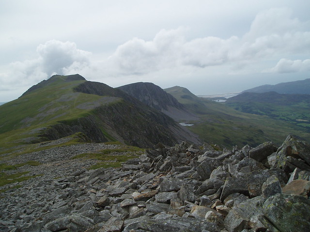 Cadair Idris by steverb_11[/url], on Flickr
Its not a hill I would be on without a map and many shops/cafes/visitor centres in the area will sell them. I find the garmin a bit of a pain for hill walking – my wife takes great pleasure in finding the route twice as quickly with map and compass. If you don’t get one before you go there are lots of online sites were you can access OS mapping and (screen)print off enough for your route. If you register for Walkhighlands you can get 1:50 openstreetmapping and 1:25k OSmapping.
Steve_BFull MemberPosted 8 years agoInteresting thread as like Trekster I have been exploring some of the areas were I started out, but which are def less fashionable now – guess its an age thing in my case. I have also just persuaded my good lady to get a hybrid for putting in miles on easier riding so interested in ideas.
Perhaps best for the OP to check what his visitor means by gravel riding. Eroded Scottish hill tracks might not be what she has in mind :-)
Around Aviemore and Nethy Bridge would also be my first thought as we discovered a lot of the tracks no longer need a mountain bike.
Pattack I agree also has potential.Glen Ogle can be made into a circular route by going through Glen Ample as it has an estate path running all the way through it – though do G Ample first and return G Ogle
This place is usually so dismissive of Glentrool I hadn’t considered it as an option, maybe need to reconsider
G Tilt, unless out and back to the bridge, would involve a fair bit of carrying on the Beinn a Ghlo circuit
G Finglas unless equipped with legs of steel and excellent brakes would be a bit masochistic on a cross bike in my view – tho I know others have done it.
Falkirk does now have the Wheel and the Helix and a (poorly) signposted circuit between them which makes for an entertaining few hours so not totally daft for a visitor – tho maybe not high on a must do list
Another option is the forest tracks from Aberfoyle – heading out through Milton to the south of L ard and then over towards L Chon. A lot of the forest has recently been cleared and there are some spectacular views. There is then potential for a loop around L Katrine and a return over by the L Drunkie tracks to take in the Trossachs
Steve_BFull MemberPosted 8 years agoFinglas is a bit of an unending ascent – esp if you have a reluctant companion. You can add a bit of variety by going up the steep track form the Glen Finglas carpark nr Lendrick Lodge (poss a push in parts)which gives some high level singletrack to start and cuts out the steep road climb to the reservoir. Then at the end there is a little path goes in by the school and finish with some easy boardwalk out towards the car park again.
Paths are shown on this map
Gle FinglasAn alternative is to head through the forest via L Drunkie and do some of the singletrack around go ape. The return by the Menteith Hills – might be a bit over ambitious though.
Steve_BFull MemberPosted 8 years agoWe did this years ago on a previous house. All done through a lawyer and no issues. But as above we paid all costs.
We tried at our current house but neighbours wanted more than we were prepared to pay.
PS Depending where you are expect their valuation and the cost to be in thousands not hundreds
Steve_BFull MemberPosted 8 years agoJust returned from Orgiva on the edge of Alpujurras and about 50k from Granada.
We hired from Avis – reasonable price and despite all the chatter on line pleasant, helpful and hassle free. (PS take out Insurance 4 carhire for excess. Also It did take about an hour to pick up the car! If there is only one driver send them downstairs without waiting for luggage! Driving is easy, roads are mostly quiet. Some complicated junctions – we downloaded Google and saved key places and it worked perfectly for directions. Every mountain road was wide and all villages had parking – though some are very narrow if you get a large car!
As said above Granada is superb – we went once to the city and once to Alhambra – could easily have gone more often. NB you will need to book Alhambra about 3 months in advance to get tickets and the timeslot you want for Nasrid palaces (the bit you really must see)PS Allow at least 30-45mins after you arrive to collect tickets and get to Nasrid . There is lots of advice on line though the whole process of arriving and getting in is a lot simpler than they make it sound.
Parking on the edge of the city is easy – we used Palacio de Congresos both times – about 15mins walk into the centre. Plenty of buses and taxis.
Elsewhere – Motril nothing to see – some pleasant coves along the coast road but probably nothing different from where you will be.
Salobrena – amazing old town well worth a hike up the hill to castle ( though closed 2-5:30)
Alpujurras – pleasant if slightly touristy white Moorish villages beyond Orgiva – with walks and reasonable parking – we spent most of our time doing that. But it was hot – our walks were all short.
Almeria – we went to Gabo/San Jose coast. Motorway is fast though it seemed a long way for not much.
Our hosts also recommended time in Malaga.
For an exciting day out how about the restored Caminito del Rey – I couldn’t persuade Mrs B on that one!
http://www.caminitodelrey.info/en/#1PS Nearly all shops are closed on Sunday and nearly all small shops close 14:00 – 17:30 and Carrefour sells the only decent beer IMHO!
Have fun
Steve_BFull MemberPosted 8 years agowheelie Cyprus are based near Polis, N of Paphos and do hire and biking. Not sure if they cater for one off days. Did approach them a few years ago – very pleasant accommodation and friendly responses but didn’t go in the end. There’s an old thread on here also recommending them http://singletrackworld.com/forum/topic/hire-shops-in-cyprus
June will be very hot for biking! We were there end of May/June last year – we were walking in Akamas and Troodos. (we were advised by tourist board that it was too hot to walk in Akamas after mid May tho we managed OK).
The main tracks (referred to as nature trails) are reasonable well signed. Pretty easy biking apart from one or two short bits – which I not sure I would have ridden.Maps are available free from tourist info (and online) tho not exactly OS standard. There is also a rather odd and old cicerone guide by Donald Brown showing a lot of walking trails for some self guiding if you have a lot of patience to follow. Used to be on Google Books but seems to have gone.
Steve_BFull MemberPosted 9 years agoI think you were asking about a year or two ago
6 years ago 8O
Ended up doing this instead as there was a better forecast and have never been back to either!
Steve_BFull MemberPosted 9 years agoDoubt it – its all forest tracks – some with better views than others – as long you can get all the junctions sorted. It might even be signposted that way. I just remembered here was a big new signpost to Old Drymen Road at 455990 pointing back that way.
I think what I recall from previously was on the west again track
Steve_BFull MemberPosted 9 years agoWasnt able to expand on this earlier – No doubt you can see it on the map but you can shorten the route through the forest and cut out the Aberfoyle leg by taking the track almost west at the multi track junction after Clashmore at 495 983 and marvel that this used to be a downhill section in the early SXC races (apparently). Turn left before Duchray cottage and you are on the Blairvach track described above. Saves about 4k but maybe easier to get the wrong turning.
Don’t think I have been on that bit in 15years tho. The route/s west of that are more up and down – includes a route with hike a bike across Moin Eich to the shoulder of Ben Lomond
Steve_BFull MemberPosted 9 years agoStu
Assuming you are following NCN7 to Aberfoyle
As you reach Kirkton just before Aberfoyle take the track W passing S side of Lochan Spling. Continue on S side of Duchray Water going under power line at aquaducts (ignore aqueduct route) and keep following track past Blairvach. Turn R over bridge – signposted Inversnaid and head along main track (ignore new tracks to pylons). At T junction turm Left on N side of Duchray water to Stronmachair (ignore Inversnaid sign to R) This links with route shown by Rich MTB towards Comar which becomes one big climb and fast descent over to WHW. Good Luck.
All very easy until climb up to and then beyond Stronmachair.
Did this last weekend as an a/c circuit from Aberfoyle going along shore of L Ard then above Kinlochard towards L Chon and returning above route. Very scenic as an alternative way to Stronmachair but more up and down.
Steve_BFull MemberPosted 9 years agoNo issues with the eye test or specs from specsavers – still prefer to walk in to a shop rather than order on-line. And I doubt any of the online options are doing any better on the tax front.
Curiously despite oldfart’s comment my last test did include the dot around the screen.
Would prefer a wider choice of frames – esp for getting something better for the bike – but one trip into an indie to enquire about Oakleys did convince me that that it would be a rather expensive option for practicing face plants.
Steve_BFull MemberPosted 9 years agoOhh my good lady meets all of those criteria* except she will be trailing around some MTB no go area north of Aviemore :wink: at the time. Maybe she should organise a more northerly variation. Mind you on current number of outings this year I suspect tea drinking might be favoured over cycling.
*tho I suspect she might be rather more elderly than you lot and hence is not allowed to be referred to as elderly!
Steve_BFull MemberPosted 9 years agoAnother anti-clockwise vote. Have done it c/w but too steep for me and descent seemed remarkably short! The track along the S of Venachar is a sustrans route and a very scenic ride. You head off to Brig of Turk. A variation on the approach to Finglas is to head on paths around BofT towards the car park nr Lendrick Lodge and a very steep ascent from there accesses a contour track to Finglas.
If you do Glen Buckie do it going North to Balquihidder. It can be excellent fun if a bit of a bog trot to start – esp if wet. I have done from N as Matt suggests but I wouldnt rush to repeat it and it is wet you will curse him all the way :wink: But he rocked on the Lednock ascent I guess there is maybe a bit of masochism going on there :-)
There are other variations – I suppose the best known is the Rob Roy way over the Menteith Hills. You can also extend from Balquihidder through Kendrum and Dubh, or round and through G Ample – now mostly an estate track and a daunting ascent doing it from the north.
Personally I dont think the ascent of Gullipen has much going for it tho I have looped together some of the tracks through Coilhallan Woods and over to Ruskie and Lennieston for a bit of all weather leg spin.
Train? Does that mean you are planning to bike from Stirling/Dunblane. That will be good few miles approach so longer variations might be stretching it.
Steve_BFull MemberPosted 10 years agoSo have I booked a duffer for riding this holiday?
There were certainly some grumpy sods in last night! Compared to riding in Cumbria (and what other parts of Scotland have to offer) I wouldn’t hold out high expectations. And saying get out a map is pretty unhelpful in that part of the world as the forest tracks are not up to date and the black dashed lines can be especially boggy.
The Leacann Muir route mentioned above is your best chance of some technical riding tho one leg of the circuit has been completely sanitised. Its not too difficult to navigate (apart from where it leaves the forest drive route – which is helpfully not shown on the OS). Also shouldn’t be too wet at this time of the year. Don’t know if it would be great fun on a CX bike – a lot is double track like above or fire road but where the forest commission haven’t semi paved it then it is still pretty rocky. Personally I would do it clockwise and the northern loop is the sanitised loop. Still a big long climb on a CX bike.
In conjunction with an OS its worth a browse on Strava heatmap – at least that shows were folk are riding – tho either there’s not a lot of off road or else not a lot of strava use!
The forestry tracks can either be scenic or tree lined misery but if you’ve done cumbrian forest you’ll know that. Havent ridden the forest tracks there so can’t comment.
There are some trails at Lochgilphead (Fire Tower Trail)that used to be worth a look if you were in the area. I understand they are no longer maintained but a quick look at Strava suggests they are still being ridden. Crinan Cycles in Lochgilphead may have some local knowledge – I’ve never asked them.
There’s always the crinan canal :-)
Have a good week.
PS satellite imagery suggests the black dashed line out of Ford might be worth a look but if you sink to your axles I didn’t say that!
Some photos from 2010 https://www.flickr.com/photos/26693195@N03/sets/72157625040220846/
Steve_BFull MemberPosted 10 years agozigzag’s route looks a good one if you can navigate it, though the route up from Linlithgow bridge might be pretty muddy.
The Callander trails are good for a blast – not technical but still fun – and be linked in to other tracks and singletrack to East and West.
Beecraigs and Muiravonside both have paths as said above – a lot of chatter on Trailscotland re Beecraigs built tracks.
Or you can drive to Tillicoultry (45mins), do Ben Cleuch – up Silver Glen and back to Tilli (2.5 hours) and back to Linlithgow – 4 hours total :wink:
Steve_BFull MemberPosted 10 years agoGood info warns74 – was aware that Bing showed the 25k but never loaded in a GPX
kcal info on veloviewer is excellent hadn’t spotted that one. How do you get it to work with Endomondo?
Steve_BFull MemberPosted 11 years agoIf you mean the route past Comer I am sure there are not any signs now. We’ve done it a couple of times recently without any problem (well other than one of our party discovering his canti brakes weren’t very effective on the descent to the loch).
I recall the Koch-Osborne books had that marked as a no cycling route – but that is going back a few years
Steve_BFull MemberPosted 11 years agoGlen Kendrum / Gleann Dubh circuit with easy return on Glen Ogle sustrans route
http://www.endomondo.com/workouts/95901465%5Dll
http://www.flickr.com/photos/26693195@N03/sets/72157631644645016/
Or for a bit of hike a bike and bog trotting (or fun depending on what floats your boat!) extend this by going along to ascend through Kirkton Glen – vague route with posts down to railway bed and return Gleann Dubh/Glen Kendrum
http://www.flickr.com/photos/26693195@N03/sets/72157605268160139/
and speak to the guys at Comrie Croft before going to Crieff – they can clarify the routes posted by others above
Steve_BFull MemberPosted 11 years agoStart of Kenny’s descent in photo below – and definitely rideable – thouigh it does get more vague and a bit of route finding is required – fun part of the ride IMHO. If Ian found it difficult then it is cos he was back packing. I think the Kilpatricks are your local tramping ground Ally – so you will be used to fighting through the heather
The alternative descent is a tedious surfaced estate track – your choice !
 [/url]
into Coire a Mhaigh[/url] by steverb_11[/url], on Flickrrest of the photos are here
http://www.flickriver.com/photos/26693195@N03/sets/72157619422288538/PS if following Kennys route watch for the river crossing after Pattack – it is easily missed and it is off a fast descent track – some I know have headed a long way in the wrong direction !
Steve_BFull MemberPosted 11 years agoflickriver works well for the IT illiterate and has quite a good presentation. Links straight to your flickr set – eg my trip to Torridon this time last year.
http://www.flickriver.com/photos/26693195@N03/sets/72157629930961766/
Steve_BFull MemberPosted 11 years agoFor a sensible extension to the Croft Trails make your way about 1k along the road and follow tracks from Fordie up towards Braefordie (shown as some ST on the 50k map tho it is a mix of old tracks). Just past the lochans before Braefordie (not on the map) you will see a grass track climbing to the W. Follow that for a fantastic descent back down to Balmuick.(also shown as ST on the 50k map tho it is also a mix of old tracks). You can then pick up quad tracks to Laggan Wood and Twenty Shilling which do have single track paths though very busy with walkers. Ask the guys at the Croft to highlight the best options on the map. (25k will be useful)
For a more strenuous option you can head over to Lednock and do the Coineachean Circuit – tho the ascent will only be done by the strongest – all on rough landy track. As Crispin points out there are a load of other low level tracks in there.
Ben Chonzie is also an option either by the main tourist route – or if you really like hike a bike- straight up from Lednock. I’ve been looking at the possibility of a circuit off Chonzie and over to Carn Chois – but googling to date suggests it is mostly heather and bog trotting.
Scotroutes option is doable (go C/W) but it is nearly all tarmac to reach the N of Lednock and requires at least an hour hike a bike on each leg (and some serious navigation) so is a committed day. I did it 8 years ago and haven’t been tempted to have another go. (My son was on a Bullet built for downhill so was well knackered on the carry a bike bits)
SwissO1’s route through Callander is a good outing tho a lot of tarmac and also a big day NB Glen Ample is now a motorway (tho this does mean you do the main valley in about 10mins!) There are ST options through Glenartney and under (or over) Callander Crags (to cut out the town)
Steve_BFull MemberPosted 12 years agoYou get the cheque.
We had 3 seperate endowments and were amongst those lucky enough to be able to pay off our mortgagewhen the first 2 matured. We are geting the red letters for the 3rd endowment – if I’m lucky it might buy a new bike when it matures.
edit – Too slow !
Steve_BFull MemberPosted 12 years agoWe used Navfree France and Italy for going from Nice airport into Italy – It did not recognise the direct motorway route along the coast – so be very careful! For a 40k route Navfree went into the mountains, came back down and crossed the motorway then went back into the mountains again. (and we did have the use toll roads option selected!)
I did not have GPS Navigation 2 but did have did have Forever Map from Skobbler (who market GPS2)which also had some pretty bizzare routes.
They were both useful at times but having said that our hire car was upgraded to one with an in-built satnav and had some odd ideas on routes.
I suppose with as with any SatNav – make sure you have a paper map and a good idea of the main direction you are meant to be taking.
Steve_BFull MemberPosted 12 years agoAnother benefit with the Ixus mentioned by S is that it has a viewfinder.
Anyone stuck in the stone age will expect one – and a screen is difficult to use in bright light for anyone with poor eyesight and/or uses prescription sunglasses or reactolite lenses.
Dead simple to use and good program mode means you can forget about faffing around with scene settings (which the older user will forget to reset anyway :oops: )
Steve_BFull MemberPosted 12 years agoSuggest you follow the Rob Roy Way through the Menteith Hills to Callander (or sustrans 7 via L Drunkie for a less muddy route). Then cycle track and minor roads to Doune. There is a cycle route out of Doune and then tracks to Bridge of Allan – after that it is local knowledge – GPX here if you wish investigate – not sure if this is the sort of thing you are after
Aberfoyle to Bridge of Allan[/url]
Not sure how you were planning on getting to Earlsburn – there are tracks – some good after a dry spell – some very boggy – non easy to navigate without a bit of local knowledge
Good Luck
EDIT Menteith Hills likely to be very wet after today. Also the bit of this route 16-17miles is a path and did have some issues with tree fall the last time I was there – it can be avoided along the road – though not a pleasant road to cycle
Steve_BFull MemberPosted 12 years agoDon’t forget to factor in the price of flowers – or a bottle of wine – for your Mum :-)