
Watching a BBC4 Documentary on Scafell Pike. How 'hard' is it to go up? The cloud inversions alone are worth it.
[url= http://www.bbc.co.uk/news/uk-england-cumbria-23144255 ]Even sea creatures can make it up there..[/url]
Fairly easy from the Wasdale side, respecting the proper mountain status part though. It can be a little grim up there to say the least. Scafell is a bit more of a challenge than the Pike side too.
Pretty straightforward.
Very stony underfoot in places.
Scafell is a much nicer mountain.
My 8 year old didn't struggle at all. Go on a nice day and it's just a few hour's walking.
With or without a bike?
Walking can be great - the corridor route is a classic from Borrowdale and can be made into a nice circuit walk. The walk from Langdale is also a good day out with options to make into a loop (I once did Langfales, stake pass, Scafell Pike back over Eski Pike and Bowfell.) Great days out. And then there's Rossett Ghyll too!
I've been up there with someone who REALLY didn't like the endless boulder field between Esk Hause and the top in fairly thick fog... it requires a lot of mild scrambling, and without being able to see where you are trying to get to I can imagine it being almost claustrophobic. We turned back before the dip near the top; we'll go back and do it from the Wasdale direction next time.
Everyone talks about the trek up.... it's the downs I find harder.
Doing the Lakes 3 peak challenge in June... Skiddaw, Scafell Pike and Helvellyn in a day .... need to get back to the digs by 8 as England play Russia in the Euros
The school dads gang (10 of us) wanted to do the "normal" three peaks, but I suggest the Lakes so that we don't spend most of the time in the back of a motor.
Looking forward to it
Are you driving between them? Cheat 😉
I love the run down to Mosedale on the Old County Tops. You need to know where you're going though.
It's a long walk from Borrowdale but nothing too tricky. Just remember there are a few lumps to go over on the way.
I've been up there with someone who REALLY didn't like the endless boulder field between Esk Hause and the top in fairly thick fog
I've actually failed to find the summit in such conditions!!
I would agree corridor route from Wasdale is the best though the Esk Hause route has some fine views when it's clear. I used to enjoy the scree run back down from Mickeldore but it's been run out for years (yes, all my fault) and is truly horrible now. The "back" route up from Cockley Beck through Eskdale and up Little Narrowcove is excellent and quiet.
Everyone talks about the trek up.... it's the downs I find harder.
It's a lot of steps, my knees were ruined afterwards.
if you go up Corridor route worth the trip up Lingmell for the view IMO
From Wasdale Head Inn, flat walk along valley
[url= https://farm2.staticflickr.com/1538/25372316471_b948999b94.jp g" target="_blank">https://farm2.staticflickr.com/1538/25372316471_b948999b94.jp g"/> [/img][/url][url= https://flic.kr/p/EE4KJg ]Path from Wasdale head towards Styhead Tarn[/url] by [url= https://www.flickr.com/photos/brf/ ]Ben Freeman[/url], on Flickr
Climbs slowly up on path to Styhead Tarn
[url= https://farm2.staticflickr.com/1628/25169621400_61c96fc353.jp g" target="_blank">https://farm2.staticflickr.com/1628/25169621400_61c96fc353.jp g"/> [/img][/url][url= https://flic.kr/p/Em9TxE ]Looking back to Wasdale Head[/url] by [url= https://www.flickr.com/photos/brf/ ]Ben Freeman[/url], on Flickr
Styhead Tarn
[url= https://farm2.staticflickr.com/1523/25346761042_45f1d0f9bc.jp g" target="_blank">https://farm2.staticflickr.com/1523/25346761042_45f1d0f9bc.jp g"/> [/img][/url][url= https://flic.kr/p/EBNLZq ]Stretcher box at Styhead Tarn[/url] by [url= https://www.flickr.com/photos/brf/ ]Ben Freeman[/url], on Flickr
From the Tarn, the Corridor Route is well defined path
[url= https://farm2.staticflickr.com/1441/24838479863_1122459aa3.jp g" target="_blank">https://farm2.staticflickr.com/1441/24838479863_1122459aa3.jp g"/> [/img][/url][url= https://flic.kr/p/DQTGGP ]Corridor Route[/url] by [url= https://www.flickr.com/photos/brf/ ]Ben Freeman[/url], on Flickr
One tiny scramble bit, maybe 20m length, with a small climb down
[url= https://farm2.staticflickr.com/1464/25346763142_9a4c5ffea0.jp g" target="_blank">https://farm2.staticflickr.com/1464/25346763142_9a4c5ffea0.jp g"/> [/img][/url][url= https://flic.kr/p/EBNMBC ]Small step in Corridor route[/url] by [url= https://www.flickr.com/photos/brf/ ]Ben Freeman[/url], on Flickr
[url= https://farm2.staticflickr.com/1619/25097637989_90254a5500.jp g" target="_blank">https://farm2.staticflickr.com/1619/25097637989_90254a5500.jp g"/> [/img][/url][url= https://flic.kr/p/EeMXon ]Tiny Scramble in Corridor Route[/url] by [url= https://www.flickr.com/photos/brf/ ]Ben Freeman[/url], on Flickr
300m slog up boulder field and you're a slightly podgy middle aged bloke on top of a mountain...
[url= https://farm2.staticflickr.com/1555/25169617980_db409b6f43.jp g" target="_blank">https://farm2.staticflickr.com/1555/25169617980_db409b6f43.jp g"/> [/img][/url][url= https://flic.kr/p/Em9SwG ]Scarfell Pike Summit Carin[/url] by [url= https://www.flickr.com/photos/brf/ ]Ben Freeman[/url], on Flickr
The walk from Langdale is also a good day out with options to make into a loop (I once did Langfales, stake pass, Scafell Pike back over Eski Pike and Bowfell.)
I've done that one. Very boggy in places - Mrs Ransos sank up to her knees at one point. She wasn't terribly impressed, possibly because I was pointing and laughing.
Pretty essy. Great day out. We did corridor route from Seatwaite Farm past Styhead Tarn also taking in Great End on way down and via Grains Gill. Took us fairly leisurely 6 hours on a beautiful clear sunny day in September. Imho the route up from Wasdale is too easy and its very crowded (peak is anyway).I think it was tmh who recommended the route. Note I am not good with heights and it was generally ok aside from one bit on corridor (EDIT: small step in photos above) and also we tried a quick detour at the start to the "rhs" of the river which ended in a bit of mild scramblimg which isnt for me. Can send you a marked up map if you want although easy to folow generally. We found a nice pub nearby at Stoneswaithe for a beer afterwards
The Corridor route is nice but the slog from Lingmell up to the top of Scafell Pike was very dull IMO. Mind when I got there I was 11 hours into day 1 of a 24 Peak Challenge and we still had Great End, Esk Pike and Bowfell to go that day, so I may not have been in the best of moods.
The Mrs and I went up last year during Sept form Wasdale and it was fantastic, we walked BTW.
Reminds me of a great challenge from about 20 years ago - read in Climber and Rambler (if that still exists)
Keswick to Coniston - start at Catbells, along ridge to Honistor, then the Gable ridge, Styhead, Lingmell and S Pike, then across to Bowfell and Crinkles to Wrynose, up on toe Swirl How and across to the Old Man and down to Consiton.
Did solo early one summer (*), weather great until Green Gable, Gale on Great Gable and S Pike and * snow by the time I got to Bowfell. Bad step on crinkles was very wet and slippy with no one else around. A bit spooky. Good lesson to have decent kit even in the summer.
Must go and do that again. Could be a fun night walk!
It's pretty straightforward from Wasdale Head, a bit of a slog but not difficult
2 things to warn you about though
- when you get to the top it's VERY easy to take the wrong route off the top. It's quite flat and not immediately obvious, there are a few ways back down
- I found the walk down almost harder, my knees were getting such a pounding that I was desperate to walk up for a bit! Walking poles might help with this, I use them if I'm walking on big downhill sections. Haven't done much walking in the last few years though, mainly biking!
It's quite busy, whether it's worth it compared with another fell is a different question, but it's a nice day out when the weather is nice
Some pics from when I did it, must have been about 8+ years ago now
[URL= http://i152.photobucket.com/albums/s189/ben_p1/abc378.jp g" target="_blank"> http://i152.photobucket.com/albums/s189/ben_p1/abc378.jp g"/> [/IMG][/URL]
[URL= http://i152.photobucket.com/albums/s189/ben_p1/abc374.jp g" target="_blank"> http://i152.photobucket.com/albums/s189/ben_p1/abc374.jp g"/> [/IMG][/URL]
[URL= http://i152.photobucket.com/albums/s189/ben_p1/abc366.jp g" target="_blank"> http://i152.photobucket.com/albums/s189/ben_p1/abc366.jp g"/> [/IMG][/URL]
[URL= http://i152.photobucket.com/albums/s189/ben_p1/abc363.jp g" target="_blank"> http://i152.photobucket.com/albums/s189/ben_p1/abc363.jp g"/> [/IMG][/URL]
[URL= http://i152.photobucket.com/albums/s189/ben_p1/abc362.jp g" target="_blank"> http://i152.photobucket.com/albums/s189/ben_p1/abc362.jp g"/> [/IMG][/URL]
[URL= http://i152.photobucket.com/albums/s189/ben_p1/abc359.jp g" target="_blank"> http://i152.photobucket.com/albums/s189/ben_p1/abc359.jp g"/> [/IMG][/URL]
[URL= http://i152.photobucket.com/albums/s189/ben_p1/abc356.jp g" target="_blank"> http://i152.photobucket.com/albums/s189/ben_p1/abc356.jp g"/> [/IMG][/URL]
[URL= http://i152.photobucket.com/albums/s189/ben_p1/abc338.jp g" target="_blank"> http://i152.photobucket.com/albums/s189/ben_p1/abc338.jp g"/> [/IMG][/URL]
We always seem to roam onto the IoM network on the Corridor Router:
[url= https://farm2.staticflickr.com/1509/24838659333_d764825dd9.jp g" target="_blank">https://farm2.staticflickr.com/1509/24838659333_d764825dd9.jp g"/> [/img][/url][url= https://flic.kr/p/DQUC48 ]Roaming to IoM![/url] by [url= https://www.flickr.com/photos/brf/ ]Ben Freeman[/url], on Flickr
And a few more I would have posted, but Flickr crashed about 20 mins ago...
[url= https://farm2.staticflickr.com/1659/25097822299_a5f10311c7.jp g" target="_blank">https://farm2.staticflickr.com/1659/25097822299_a5f10311c7.jp g"/> [/img][/url][url= https://flic.kr/p/EeNUb8 ]Descending Scarfell Pike to the east[/url] by [url= https://www.flickr.com/photos/brf/ ]Ben Freeman[/url], on Flickr
[url= https://farm2.staticflickr.com/1515/25439230506_8a8185f796.jp g" target="_blank">https://farm2.staticflickr.com/1515/25439230506_8a8185f796.jp g"/> [/img][/url][url= https://flic.kr/p/EKYGWw ]Summit Boulder Field[/url] by [url= https://www.flickr.com/photos/brf/ ]Ben Freeman[/url], on Flickr
[url= https://farm2.staticflickr.com/1663/25439230306_75789f55e5.jp g" target="_blank">https://farm2.staticflickr.com/1663/25439230306_75789f55e5.jp g"/> [/img][/url][url= https://flic.kr/p/EKYGT5 ]Looking back towards the Corridor Route & Great Gable[/url] by [url= https://www.flickr.com/photos/brf/ ]Ben Freeman[/url], on Flickr
[url= https://farm2.staticflickr.com/1590/25169619950_5834d6f262.jp g" target="_blank">https://farm2.staticflickr.com/1590/25169619950_5834d6f262.jp g"/> [/img][/url][url= https://flic.kr/p/Em9T7E ]Start of the Corridor Route, just up from Styhead Tarn[/url] by [url= https://www.flickr.com/photos/brf/ ]Ben Freeman[/url], on Flickr
[url= https://farm2.staticflickr.com/1629/25439052476_3488ba3b8c.jp g" target="_blank">https://farm2.staticflickr.com/1629/25439052476_3488ba3b8c.jp g"/> [/img][/url][url= https://flic.kr/p/EKXN23 ]Wasdale Head Pack Horse Bridge[/url] by [url= https://www.flickr.com/photos/brf/ ]Ben Freeman[/url], on Flickr
[url= https://farm2.staticflickr.com/1479/24834644134_f29297da49.jp g" target="_blank">https://farm2.staticflickr.com/1479/24834644134_f29297da49.jp g"/> [/img][/url][url= https://flic.kr/p/DQy3ty ]Corridor Route[/url] by [url= https://www.flickr.com/photos/brf/ ]Ben Freeman[/url], on Flickr
We did it as a 2 day trip, starting in Borrowdale, staying in Wasdale Head Inn over night and then returning via Scarfell Pike.
Sprinkling Tarn is very lovely, well worth slight detour on way up/down on "my" Corridor/Grains Gill route suggestion
Just posting makes me realise its been too long (4 years) since I was there
Translation services ...
Bad step on crinkles was very wet and slippy with no one else around. A bit spooky. Good lesson to have decent kit even in the summer.
Absolutely terrifying
footflaps - nice pics but your spelling offends me 😉 (Scafell Pike)
Like most mountains it is complex and varied and your experience will be deeply affected by the weather. On a lovely day I've seen hundreds of folk up there, including people with guitars!
Agreed the quietest way is up from Cockley Beck. Also agreed it's worth getting the compass out on the top before committing to a path down.
footflaps - nice pics but your spelling offends me (Scafell Pike)
oops..
I carried my bike up and down it as part of a mentalist version of the three peaks
Agreed the quietest way is up from Cockley Beck. Also agreed it's worth getting the compass out on the top before committing to a path down
We descended via Little NarrowCove and down to the River Esk. Didn't see a sole until we got back to a main route between Sprinkling Tarn and Angle Tarn.
If you get lost in the clag coming off, it's likely you'll be in upper Eskdale, which is where most lost walkers are found. Don't underestimate the trip, and be happy with basics of navigation, and you'll be fine. Take a torch and more food than you think you'll need. I like the round trip from Seathwaite described above.
A friend of mine took part in a hastily and badly organised charity walk up there. They took a page from a Wainwright book & no map. The party started out as 4 or 5 (including a child) but went down to just 2 as the day closed in. They stupidly continued, got lost, fell out and foolishly went their separate ways. Luckily, they found each other and ended up in an equipment locker on Mickledore, and had to do a bit of brokebacking. They were very lucky, Wasdale MRT found them before they got too cold.
http://www.wmrt.org.uk/incidents/mickledore-scafell-pike-sun-28th-oct-2012/
I like the round trip from Seathwaite described above.
next time we're up we'll try a 2 nighter: Borrowdale to Wasdale Head Inn, then over Scafell Pike down to Old Dungeon Ghyll Hotel (sp?) and then back to Borrowdale.
and had to do a bit of brokebacking.
Having seen the movie I can't imagine any amount of getting lost in the Lake District would end up that way 🙂
@hora get it done !
They were very lucky, Wasdale MRT found them before they got too cold.
118 man hours to sort them out!
If you want to spice things up, cross over to Mickledore and then go up Scafell by Lords Rake and the West Wall traverse, its brilliant.
As above, Scafell is the better mountain.
[img] 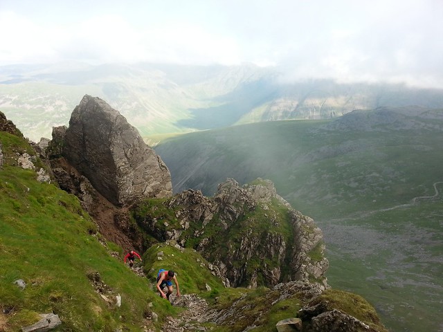 [/img]
+ 1 for the nav being tricky when the weather closes in. I walked round and round in circles trying to get back down to the Corridor route once, for about an hour!
But like most of the Lakes, it's great scenery when there's a view and a great day out, albeit not the quietest re numbers of people.
Quite remote too.
118 man hours to sort them out!
Yep, bellends the pair of them. We never miss an opportunity to let them know how stupid they were. We also gently encouraged them to make an appropriate donation to WMRT.
Up corridor, down wasdale front. Straight up and down is too boring. It's a good couple of hours for a fit adult, half a day with kids.
them to make an appropriate donation to WMRT.
Let's say £25 per man hour, that's £2,950!
Whats conditions like currently and the roads getting up there? I imagine theres a bit of snow up there currently.
I'm also one who prefers the backside approach, Great Moss is a fantastic wild camping spot (under cam spout crag), with really nice walk in along the river esk. as others, Scafell is the more interesting, up Lord's rake, down Foxes Tarn path
Is that big perched boulder still overhanging Lord's Rake? The one the MRT said was going to tumble down any time now?
Currently snow on the high fells, some of which will have melted and refrozen into hard neve. You can't drive from Grasmere to Keswick, so for borrowdale approach need to come into the north lakes from Penrith. Pick a good weather day to make the most of it and reduce possibility of getting lost, but bear in mind it can clag up pretty quick even on a nice day, so be prepared for that!
The OS map app is very handy on your phone - shows you where you are on the 1:25k at all times (don't need cell coverage).
I'm also one who prefers the backside approach, Great Moss is a fantastic wild camping spot (under cam spout crag), with really nice walk in along the river esk. as others, Scafell is the more interesting, up Lord's rake, down Foxes Tarn path
I'd second that - top camping spot. And some nice swimming holes higher up the Lingcove Beck underneath the Crinkles. Just check there's no large groups of walkers approaching before stripping off for a dip. 😳
Just make sure your nav is up to scratch if you're going up Scafell. You don't want end up above Broad Stand thinking it's the path down.
You don't want end up above Broad Stand thinking it's the path down.
First time I took the missus up to the Lakes, must be almost exactly 20 years ago now, we ended up doing just that in a howling gale. I *think* she's forgiven me...
(fortunately a nice man acted as a spotter for us and directed us down the safest route to the col)
Hora - roads fine, but if you 're asking about fell conditions, I'd suggest you leave it a while or head for a shorter challenge - Blencathra maybe, or Green and Great Gable. Are you just wanting to do 'the highest'?
Looking at the Buttermere Fells now, there's snow from about 500m on the east side. It'll be yucky wet snow. On Scafell, there'll be this plus some older compacted snow.
If not experienced, I'd advise an ice axe and a knowledge of how to use it, depending on the route.
Went up there years ago and came down the corridor route which was a bit scary given I'm prone to vertigo. Only as short section as some other posters photos have shown
Boxelder cheers and noted. I'm not that skilled so will take heed.
Erm, yeah. I needed axe and crampons on Blencathra two weeks ago....They've had a bit more snow this week I think.
This thread and prompted me to go back again, so just booked a night in the Wasdale Head Inn and the next night in The Old Dungeon Ghyll Hotel for the week before Easter. All we need now is fine weather, else we'll be trekking for three days in torrential rain and cloud!
It could equally be clear blue skies and thick snow. Easter is early this year.
Been a long time (93/94 ish) since I've been up there with snow + sun...
[url= https://farm9.staticflickr.com/8379/8454690266_a7d274431c.jp g" target="_blank">https://farm9.staticflickr.com/8379/8454690266_a7d274431c.jp g"/> [/img][/url][url= https://flic.kr/p/dT7uRQ ]DOUG ON KIRK FELL[/url] by [url= https://www.flickr.com/photos/brf/ ]Ben Freeman[/url], on Flickr
We climbed it last easter with our 5 and 8 year old. Easy for the 8 year old but the 5 year old got up ok but I had to carry her most of the way down. It was perfect conditions though
This thread has really inspired me! Any ideas what conditions are usually like in April? I have a couple of days off work after Easter. I want to tackle the ascent direct from the National trust camp site. Obviously I'll be checking the forecast closer to the time, but anyone got experience of that time of year?
Could be anything from 20 degree sunshine to deep snow and ice. Currently quite snowy but forecast warm spell may strip all that off. lake district weatherline and mountain weather information service (MWIS) are your online best sources for info. Often spring can give great conditions, but as always it varies day to day.
Thanks TomB!
I want to tackle the ascent direct from the National trust camp site.
Imagine walking up a bajillion flights of stairs.
@thestabiliser have always preferred this route as it gets a huge amount of the altitude out of the way relatively easily. Would you recommend corridor for the ascent?
Yeah, much better. good views of the surrounding ranges too.
Longer obvs.
Thanks! How about this route?
https://www.walklakes.co.uk/walk_208.html
Imagine walking up a bajillion flights of stairs.
Try going straight up Kirkfell after a full cooked breakfast at the Wasdale Head Inn!
There's a scramble if you've kids with you that might be a bit intimidating but otherwise yeah, that'd be my route from Wasdale