working in an electrical panel with a very melty Hi-Viz & no hat/eyewear
Normally you're standing on a thick rubber mat, so you won't be the path to Earth...
Most 3 phase stuff is maintained live, even splicing 3 phase outdoors in the ground, they just did a big hole around the cable, throw a big mat in the hole and then cut it open live. With a 600A fuse per phase, it's a big old bang if you drop your spanner across the phases!
Don't worry about Banks Data Centers, they're not in London.
Every individual Bank has its own DR plan and sites are dotted around the country that hold all the Data and copies of it are continually being done throughout the day.
I can't say where they are, but I do know the biggest are in Northamptonshire.
I could have got you round on the sly a few years ago, it would be too much of saga now, it's on a high level of lockdown.
Sorry, I didn't mean that cheeky 😀 I was thinking more of a ride from central London along the river to it, and then seeing what we could see from the riverbank - with you as a tour guide... but obviously only if you'd be happy to and you think we'd see enough to be interesting...
And the reality is there is still so little certainty on the lead in timescales you understandably require. Think the future forecasts are pretty robust if you assume Antarctica isn't going to do much, but that could potentially be an expensive mistake!No one has decided, new studies and guidance is carried out all the time. Reading between the lines of the current guidance pretty much everyone agrees the current infrastructure will do until 2040. Problem is, for a project that size you really need to start thinking about a replacement now, like really planning and having a permanent team in place dedicated to this one outcome.
Currently putting a project together to see if we can improve sea level forecasts for the UK for 2050-2150 with exactly this in mind - the lead in time for large infrastructure projects. Problem is we will still only come up with a range!
That's a brilliant project. Technology is wonderful.
Seems a shame not to simply let the water rise and adapt the buildings over time. London would make a great Venice.
Must see if there's a bomb aimer's job going on Scotroute's Lancaster...
Sorry, I didn't mean that cheeky I was thinking more of a ride from central London along the river to it, and then seeing what we could see from the riverbank - with you as a tour guide... but obviously only if you'd be happy to and you think we'd see enough to be interesting..
Be saga for me, I live in Worthing and I've got a 2yr old and a 5yr old. I'm pushing my weekend away riding limit for the year already... 😐
Perhaps I can pretend I'm at work... hmmmm
I've got loads of this crap in my head, been managing projects here for 10yrs, I'll stop spamming the forum now. I'll leave you with one for the 'I didn't know that' thread.
In the 48 hours 23/24th December 2013, the Leigh Flood Storage Area, upstream of Tonbridge helped to manage 22 million tonnes of water. At peak, 340 tonnes a second were flowing into the storage area down the River Medway.
More threads like this please!
Sod all use in an arc flash event.footflaps - MemberNormally you're standing on a thick rubber mat, so you won't be the path to Earth...
Most 3 phase stuff is maintained live, even splicing 3 phase outdoors in the ground, they just did a big hole around the cable, throw a big mat in the hole and then cut it open live. With a 600A fuse per phase, it's a big old bang if you drop your spanner across the phases!
HV or LV ?
Live working is massively frowned on in almost all situations. Plus the huge amounts of checks & paperwork means its just not worth the risk.
Be saga for me, I live in Worthing and I've got a 2yr old and a 5yr old. I'm pushing my weekend away riding limit for the year already...
No worries, I'd assumed you lived in London... great thread though, thanks
oo, oo, I have a friend on FB who is outdoing this thread.
He has spent today, and will spend the next week or so, filming around Chernobyl. The old control room, deserted reactor halls, inside the sarcophagus....
I will see if I can share some images - its bonkers...
Great thread, really interesting insight PR!
Thanks for the very interesting thread!
Image about the number of closures since starting operation. We count in winters (also called 'flood years') to have a fairer year-to-year comparison of storms.
[img] 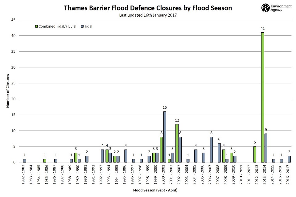 [/img]
2013/2014 had more closures than the preceding 10 years total. Rising mean sea level will be affecting these closure rates, as does the fact we are in a period of highest astronomical tidal range (on an 18.6 year period cycle). Some of those closures were the same 'event' in that the fluvial (rainfall -> river) flow was high over a number of tidal cycles, so the barrier would be open at low water to let the river flow out, then raised before the incoming tide to make the storage available for the river water, then lowered again with the ebb tide to let the river water out, etc. There were so many closures because the storm tracks kept hitting the same parts of the UK, which in part answers
brooess - Member
What happens in the scenario where the barrier has to be shut to keep a tidal surge out of London at the same time as unusually high levels of water come downstream from Windsor direction?
It is reasonably unlikely that a very big storm surge will occur at the same time as a very big rainfall event -> river flow. The storm tracks that give the highest storm surges centre north of Scotland and cause high surge once they have passed the UK by blowing strong northerlies into the North Sea. Whereas the big river flows happen with heavy rainfall over the south of England. However, it could happen. The EA run the storm surge model to make prediction of high water but also have a high resolution estuary model that is used for decision making for that type of scenario.
captainsasquatch - Member
...
EDIT: And what's the height difference between levels?
In the worst events recorded, the water on the upstream (city) side will be around the low tide level when the barrier was closed plus a little bit for river discharge, so around -2 mAOD. The largest total high water level during Dec 2013 was 4.1 mAOD; during the last event in Jan 2017 around 3.5 mAOD at Sheerness out in the estuary downstream of the barrier. So very roughly 5-6 m difference across the barrier.
[url= https://twitter.com/johncurtinEA/status/827633831532429312 ]link to a tweet about the recent storm water levels[/url]
Hard to tell from that pic , but is it designed to allow 'overtopping'?
So the gates ca be closed at low water plus 2. Then the incoming tidal push builds and the upstream capacity gives a massive volumetric buffer to allow for this.
Obviously if it overtopped hugely, with a tapering upstream catchemnt and some ( managed ) fluvial flow then flooding would occur somewhere .
Is there an area downstream of the bar, with its own defences which is designated as sacrificial in extreame weather events ? Open a gate and flood maybe Gravesend for example?
konagirl...just done some google stalking based on your email address as your post sounded like that of an academic and if I've got the right person, realise we know a lot of the same people, in particular Ivan Haigh. I was down at NOC last week seeing him and giving a seminar! Small world!
Don't worry about Banks Data Centers, they're not in London.
Well, I know of at least 2, if you count Croydon as "London"
By overtopping I mean over the banks to the sides; I don't think the structure is designed to act as a weir (I would be interested to know if it was), so I believe flood water would be directed around the sides/one or two sections would be opened up if water levels got to that height. I know the barrier park was designed to allow a certain volume of fluvial water to overtop there, as additional storage, just in case.
I am sure the EA together with local Councils have plans for various scenarios. But opening up flood gates to the east of the barrier probably wouldn't 'save' central London from flooding because the tidal potential and surge are very long wavelength so the water level wouldn't really drop in the estuary. Also a lot of the industrial areas to the east with big flood gates are drained wetlands where land levels have sunk, so they would flood rapidly causing a real risk to life.
ahsat - Member
konagirl...just done some google stalking based on your email address as your post sounded like that of an academic and if I've got the right person, realise we know a lot of the same people, in particular Ivan Haigh. I was down at NOC last week seeing him and giving a seminar! Small world!
Gahh! I've been found out. Small world indeed. Although I am currently in Australia, so it feels a very big world when missing home 😉
EDIT: Also "sounds like an academic" = must work harder on science communication and simplifying my language!!
It's not designed as a weir afaik. The Barrier park is an offline storage area. Central London has the highest standard of protection against flooding in Europe outside the Netherlands. (They have other issues..) If that overtopped then your looking at a nasty* flood situation and all the emergency services would be stretched to their limit.
In the event that was looking like overtopping then I suspect you'd be making some tough decisions on flooding land in the estuary to try and hold the peak. A gold command would be set up and it would be a ministerial (maybe higher) decision to make.
I'm not doing it.
Haha...not at all, but an academic can always spot another 😛EDIT: Also "sounds like an academic" = must work harder on science communication and simplifying my language!!
Say hi to Matt King if you see him...he was my PhD examiner!
Just caught up as I had bookmarked this for later reading. What an interesting thread.
Reminds me a bit of a University field trip to the Netherlands, to look at their tidal/storm surge defences, and we went to visit this:
[img] 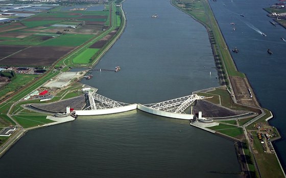 [/img]
I find the engineering and construction of this huge infrastructure fascinating. Top work all 🙂
