This sounds fascinating:
http://www.bbc.co.uk/news/uk-scotland-40359829
Website eventually loaded to a UK map then it was once again stuck. Repeated attempts have failed.
Has anyone managed to check it out?
Still on the spinning wheel of death. Maps has loaded but nothing else appearing. Tried first thing this morning too.
Dead keen to find out if there are more forts around here, maybe do a new loop on the cross bike to find some - over 400 in the Borders is pretty incredible!
dmck16 - eventually the functions appeared and I found a link which explains how it all works. I don't understand the criteria they've used for defining a hillfort and am finding it hard to navigate. Actually, I've just given up. 😆
400 will keep you busy!
"The layer, Hillforts, cannot be added to the map."
Okay then.
Anyway, local to me. There's one on Holmbury Hill. One in Swinley forest called Caesars Camp, not to be confused with Caesars Camp near Aldershot, which also has a hill fort.
I guess they werent expecting a large number of users.
Finding the mapping rather fuzzy, nothing like the quality of Google maps.
Have tried searching for specific hillforts and they don't exist!
If you open the landranger (analogue) for Peebles the number of Hill for is incredible
The entries for Kent are surprising lacking.
Bigbury Camp is there. It was besieged by the roman 7th legion led by a young Julius Caesar and fell after a titanic battle. The romans then marched down the stour valley to Chilham where the local tribes ripped the 7th a new one.
I know of at least 3 more within a 5 mile radius that aren't marked. Work in progress I guess.
Thanks for sharing!
Woo and hoo I now have orange dots on the map. 8)
Thanks for that link redthunder, looks very interesting. 🙂
Working now. Zoom in a fair bit and it much better detail.
A few others about my area I didn't know about.
c_g - Thanks for sharing
45 hillforts within a 5 mile radius of my house in Galloway, i guess i've only been to 10 so i may explore the rest over the weekend
I assume all the Scottish sites are already on Canmore?
https://canmore.org.uk/site/search/result?SITECOUNTRY=0&view=map
National Heritage List for England here:
https://historicengland.org.uk/listing/the-list/
Also note the Enriching the List pages should any of you wish to add photos to the end of the statutory record.
Loaded really quickly, amazed at how many orange dots there are across the SW, looked at local ones and there's one really close to me overlooking Lacock which I didn't even know existed!, cheers for the link, loads to check out now. The nearest large clear one to me I can almost see from my house!
[IMG] 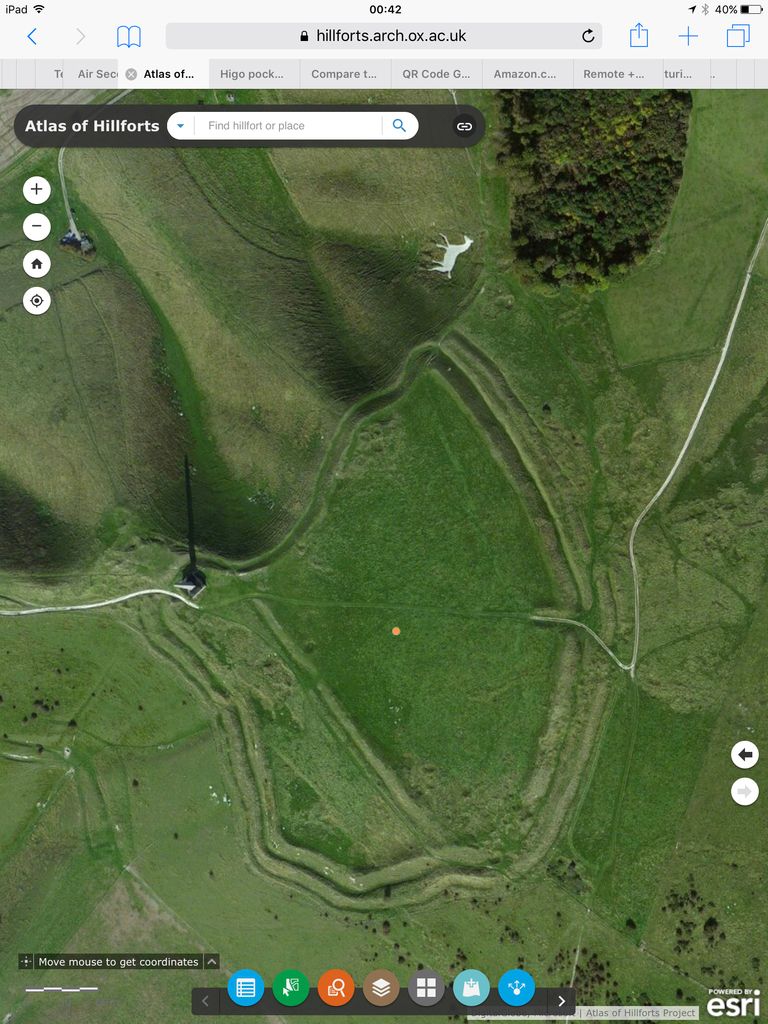 [/IMG]
The white horse and the monument are the most obvious features from a distance, though; the horse can be seen for miles after it's been cleaned up.
Glad everyone is enjoying the mapping. 😀 I've been using it in conjunction with paper maps and trying to ascertain what can be legally explored via rights of way. Can't believe that somafunk has 45 hillforts to explore, that's an awful lot!
CZ - that looks like Cherhill?
Cheers for that, always a fan of anything involving maps. And I live near Northumberland where there are hundreds of hillforts - will have to go and find some!
[url= http://www.halfords.com/webapp/wcs/stores/servlet/storelocator_storeId_10001_catalogId_10151_langId_-1 ]Halfords of UK and Ireland mapped[/url]
Awesome. Thanks for posting this.
love it
often wonder whethere every hill you pass might have had a fort/barrow on it
Interesting map. Interesting distribution of dots. Lots in SW/Wessex/Mercia/Wales and very few in SE. Is that a historical/geographical thing, or still a work in progress?
One in Kent I was aware of is there, but I'd have thought there'd be more.
There was another map somewhere showing all of the military installations (pillboxes, tank traps, etc.). Think that was an overlay for Google maps/earth. That was quite interesting. Loads on that I was aware of, but even then, there were still some in neighbouring farms right under my nose that I never even knew were there.
WOW. Just started digging a bit deeper into the records on there and it is amazing how little archeology has been carried out on many of these sites.
Just with 20 miles of my old home in the motherland there a incredible number and very few have had any works at all.
Cheers for the link - have had to tear myself away and stop myself from Googling for metal detectors 😀
http://www.fusilier.co.uk/widdrington_northumberland/low_chibburn_preceptory_dower_house.htm
Here is one I have been to. Used to windsurfing near there and have been geocaching there too.
I thought I knew the history of it. But a French raid in 1691? Well I never.
Fascinating uphillcursing, will have to check that out when I'm next passing that way.
There was another map somewhere showing all of the military installations (pillboxes, tank traps, etc.).
Do you have a link please?
Missed my favourite - Helman Tor 🙁
[url= http://cornisharchaeology.org.uk/journals/No.36_1997.pdf ]Linky[/url]
Perhaps Neolithic don't count
Lots in SW/Wessex/Mercia/Wales and very few in SE
Its possible that the a lot in the SE have been lost through intensive farming or being built over so there isn't much evidence left.
I'm glad they've included one of my local ones - Calleva Atrebatum. Its a Roman town, but underneath that there are pre-Roam defences and an Iron age "town". However they only know that because there have been about 20 years of intensive excavations!
C_g, that is indeed Cherhill, they gave the horse a sprucing up a little while ago, and it's really bright now, you can see it from some high places around Bath.
There another fort at Naish Hill, above Lacock, but that ones mostly built over, never knew there was one there.
CZ - didn't realise it could be seen from so far away!
Harumpf! I was hoping for some new local ones, but I have visited them all...
I can head towards Callander and find a few, and one buried under a housing estate in Bannockburn, but that is it 🙁
I am off to Galloway to see whats around somafunk's place...
That's just boasting matt! How about listed buildings/parks and gardens/monuments in your hood?
How about listed buildings/parks and gardens/monuments in your hood?
Lots to see - Canmore is useful, but again lots done.
My office is between these two - both summits are hillfort sites, including the Wallace monument built over one.
[img] 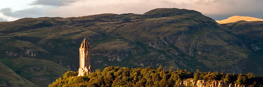 [/img]
Nice pic and what a location for an office. 😀 Of course you can wander wherever you want, I think I may need to be creative for some.
