@welshfarmer https://coflein.gov.uk/en/site/407866/
It’s not very obvious on the ground unless you know it’s there.
Those are difficult.
@Houns - is that part of a county cricket ground?
@welshfarmer - somewhere in mid Wales or Shropshire?
Late again!
Ooh can I have a go?!?!
Yes!
Pen y fan?
Nope sorry 😞
Nope but quite similar
Somewhere in the Howgills?
No, that's too far North
Fan Foel. Just north of Ammanford I think?
Edit: nope Picws Du, just west of Fan Foel
Can I play?


The best bothy in the world?
Tillydogs has a definitie southern uplands vibe to it. Glentress area. I will have a good look on GE and see if I can match it. Listers Bothy is NW highlands somewhere at a guess. Skye maybe?
Mine is much further south...
I thought @Lister's might be near Uisinis (Uist), but having looked, I don't think it is.
(Apologies to Lister for diving in - I thought it had gone quiet.)
Deadwater Fell?
No - much, much further south. It's a very popular spot.
Moel Famau and Camus Fhionnairigh?
Moel Famau
Yes! 🙂
Camasunary bay. I knew i'd been there. But we're talking 35 years ago!
Well done fasgadh.
powfoot
i’ve been in that pool, about 50 years ago.
I come from Annan, which is a few miles away, and an aunt lives in powfoot.
@Houns By any chance, are those trees (or woods, if you will) behind a major building society's offices in a large town in Wiltshire?
Uber niche knowledge required for this one. Or just local.
https://imgur.com/a/9DNN7AI
Yep, Camasunary. Amazing place for a Kip.
I've worked out the arrow one from Rich_s with a bit of googling as I was familiar with a more famous one on Brean Down, it's to guide pilots to the bombing range, built WW2 era.
Fritham New Forest, north of the ridge bridleway between Fritham and Frogham
Yup and yup. Well done 👍
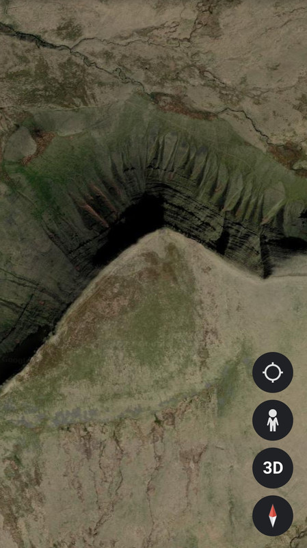
I've never been to the range (Ashley Walk), but was wondering if there was a crater from a grand slam or tallboy bomb drop I could put on here. Then I remembered that arrow!
Friend showed me on a ride a few years ago. Little oil pot holders in the arrow to show a flare path. I was told it was used to plan an attack on a submarine pen
Static caravans - check
Sea cliffs - check
Choo Choo track - check

Geoguesser is a favourite with some of my pupils. Best I ever got was 2 metres, Christ the Redeemer, Rio.
Geoguesser is a favourite with some of my pupils. Best I ever got was 2 metres
We got to 2 or 1m. It was a random junction in a small French village. We tracked it down by looking at the road signs and a business that was in the shot.
@ElShalimo it took a while but found it in the end. I assumed that you hadn't changed the orientation which made me think of the NE coast. Found a railway line that ran close to the cliff and voila. Marshall Meadows bay. Does this p[lace have any significance to you or was it a random choice?
Anyway, I will now go and find a MTB related one
[img]  [/img]
@welshfarmer - many of us Northumberland-philes have walked all or most of that coastline
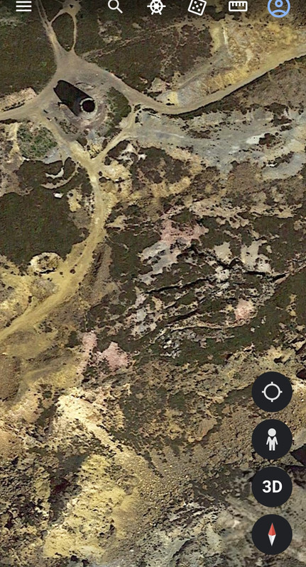
Those berms are doing my head in! Are they in Wales?
I want to say BPW but can’t find them there…
@lister, not BPW. Won't give any more clues though as they will be obvious to several on here I am sure.
Alright. A little clue. I haven't ridden them 🙂
Dalby Forest?
Whinlatter North?
