Definitely easier to plan the route with a mug of tea, pencil and map. You need a bigger floor than in my front room to see it all though, I'm off to the garden!
[img] 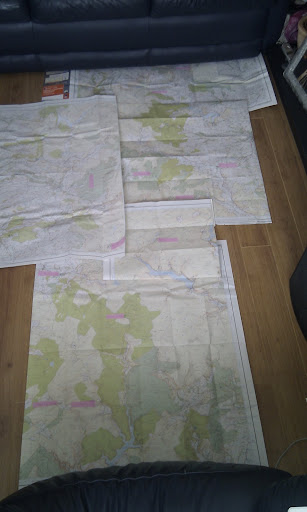 [/img]
Don't worry about it over-active. I am doing it with my OH, who doesn't ride that much. We are just planning lots of short-cuts. It doesn't matter if we get all the points or not we just thought it would be nice to do an event together. She is usually my support crew! Did a practise bivvy the other week with her. Now I am left to sort kit etc!
Paulio I can see my house from here 😀
Yep, just under the sofa!
[i]We are just planning lots of short-cuts.[/i]
I cant find any!
If anyone is interested, some options for gathering provisions en route are. Devils Bridge, campsite shop at Woodlands which is 300m from the bridge on the Ponterwyd road, they do take away fish n chips on a Saturday as well. Also small general store just up the road from the station heading towards Aberystwyth. Ponterwyd, small general store with erratic opening hours, better bet is BP petrol station on the main road heading towards Aberystwyth. Pont Rhyd Y Groes, store on the Llanafan road, go up the hill past the Miners Arms and fork right and its 100m. Pontrhydfendigaid,small general shop opposite road to Strata Florida not sure of opening times. This is not a definitive list but ones I know about which shouldn't involve too much deviation from our routes.
all kitted out for a trial run this weekend, about 100 miles with wild camp.
well that went a bit tits up today, set off for 100 mile ride, within 1 mile a bloody big rhodesian ridgeback has taken a chomp jump below my knee.
no idea when my last tetnus was so of to have a jab in the morning.
told the wife i've got rabies now but shes not that sympathetic, cow.
Bloody hell! and I thought I was having problems
Well I have planned a route about 100 miles with about 14000 feet of climbing but missing out 3 checkpoints on the basis of 1 out on a limb, 2 too far south and 3 cant see a trail to it
No idea of road/trail % but seems like a lot of road
If the one you are unable to see a trail to is the one near the Teifi pools, it is approached from the due South off the tarmac road, a track is visible from the road. Lovely location 🙂
"The track is visable from the road" ... just 😉
flatfish sorry to hear about that ... has the dog got any teeth left? My outing into the mountains had to be put back too. Trip to Aber' A+E with a customer, got back around 5 to find Stephen Lord (bloke who wrote Adventure Cycle Handbook) here with Peter his mate who's 5 years into a round the world ride. Best laid plans, etc.
Over-active ... just a thought, you're not planning using 1:50000 maps are you? They don't really have enough detail on them IMO.
Stuart
sounds like its possible to pick up food on the way, so i'll only have to carry snacks, but what about water?
Is the water fine to take from running streams, without filtering?
Re drinkable water, the Elan Valley Reservoirs are the water supply for Birmingham, I'm taking water purification tablets as I don't want to start talking in a Birmingham accent like most of the local residents 😕
Take a pack of Chlorine Dioxide tabs just to be sure I reckon, lots of sheep = campylobactor and cryptosporidium
As for food, you are potentially quite a long way from food sources and a delay of some kind could easily put you outside opening times, especially on a Sunday, so I'm going to carry a decent sized dehydrated meal in case all that is available is crisps and mars bars.
Natures takeaway
[img]  [/img]
If you take your water from high ground, from a fast running stream then you should be fine ... watch me be i'll now next time I'm out 😀
Still not had chance to plot a route! Should get a chance next weekend all being well.
And my frame bag has been delayed and will not be ready until next weekend now.
Last year after plotting on my OS maps I swapped them to a decent road atlas to view the big picture. With all the maps, and not really knowing the area, could not work out what made up a decent route. Helped me sort out a route. IIRC the Teifi pools from last year there was a little 'fishing' sign taking you up there from the main track to the South.... Was chucking it down with rain at the time so glad of any assistance.
i think your thinking of anglers retreat, as our route last year went nowhere near teifi pools, unless you were hopelessly lost. 😯
And my frame bag has been delayed and will not be ready until next weekend now.
if it's coming from eric i would expect least another fortnight due to customs and the lazy gits at parcelforce. 😥
We never get lost, we just lose contant with the map 😉
Tis true though ... Teifi pools was a loooong way off last years route.
Just been looking at my route, I'm relying on using the bridleway up Afon Arban, which I fully expect to be off and pushing, but can anyone shed any light on just how bad it is? It's the only section that's worrying me, and visits to Geograph are making that worse!
Where?
Afon Arban - I've been through it twice, but not for many years. Bridleway is largely non-existent and you have to carry bike over tussocks for miles which is really tiring.
Last time I did it it was as a "shortcut" from Claerwen dam to Strata Florida. A few hours later I was still trudging through and wondering if I'd get out of the valley before darkness.
If anyone has more recent info please update. I'd consider it if going downhill (anticlockwise) but not up.
I was planning on using that bw, but after studying geograph.org.uk and google earth I decided against it.
I'm generally of the opinion that if there are few pics of a square then that is because hardly anyone goes there, there might be a reason for this....
[b][url= http://www.geograph.org.uk/photo/1204133 ]Carreg Wen Fawr
[img] 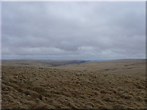 [/img][/url][/b]
© Copyright [url= http://www.geograph.org.uk/profile/34379 ]Dan Taylor[/url] and
licensed for reuse under this [url= http://creativecommons.org/licenses/by-sa/2.0/ ]Creative Commons Licence[/url].
I see it now, I went looking for it a couple of years ago, the start from the forest road is visible but quickly turns very boggy, then when you leave the forest it disappears all together. Not recommended.
From my research none of the bridleways crossing from Claerwen over to Afon Tywi are particularly pleasant.
Possibly time for a route re-think...
I'm starting to think it might be a good idea if I've 'left town' by the time everyone returns on the Monday ... there's an awful lot of trees here you could throw a rope over 😆
Stuart
Oh the joys of being an organiser! I ran Trailquests all over this area from Machynlleth to South of Devils Bridge for 7 years without a single complaint from either riders or landowners until the last one where a rider moaned about there being too many gates!
I don't think anyone will have the strength to do a lynching by the time we get back. I do think you have made a tremendous effort to guide riders to some of the best riding in the area without it turning into a procession, if people chose to make life difficult for themselves then what can you do?
So, appart from the Doethie Valley 'must do', anyone want to share some hints as to other really good bits?
Loads of 'must do' bits Nick, ie you 'must do' them to get round and make it back 😉
Some of the views/locations alone are worth a push, carry, swearing session but I have to admit, it ain't no trail centre.
Ok 🙂
Glansevern Arms at Pant Mawr , is it still there, does it sell food and beer?
It was there last night. The Dyffryn Castell just down the road towards Ponterwyd is covered in scaffold though, don't know whether it's open atm. This route has the makings of an epic pub crawl, my route passes the Star, Hafod Arms, Miners Arms Tafarn Teifi, Red Lion, Black Lion, Dyfryn Castell, Blue Bell, hic
It was the Anglers Retreat, think I went near Teifi ponds on another adventure.
Frame bag is not one of Eric's, having one made locally.
nostoc - Member
I'd consider it if going downhill (anticlockwise) but not up.
Going down it is our Plan A.
If it doesn't rain between now and then it may stay in our plans.
What do the locals say?
Have a Plan B, and play it by ear
The bridleway from Teifi pools to strata florida is good, as is the descent off the north end of monks trod. I don't think most of the bridleways from Claewen to Teifi valley are very good. There's a bit of a line over Drygarn Fawr, but that's a bit too far east.
Going down it is our Plan A.If it doesn't rain between now and then it may stay in our plans.
The wetness of the trail isn't the problem, the problem is that it isn't there or at least isn't visible from the forest exit. I rode across Esgair Garthen a few years ago and there seemed to be a fairly good sheep path leading across to the forest at Crug Yr Wyn, you could try exiting the forest there riding east along the edge of the forest to the corner and taking a NE bearing to pick up the bridleway at the highest point. Could be a bit dodgy in poor visibility and it is a long way out of your way if it goes pear shaped. Wouldn't be my choice. Definitely avoid the west side of Esgair Garthen SQ 80 &81 it will drive you mad.
so if coming from claerwen dam, could take the track up esgair garthen and then bear off on to sheep track in to forest at Crug Yr Wyn instead of the Afon Arban bridleway?
In theory but if the cloud or mist obscures your veiw of the thin line of trees you will only have GPS to go off. Also the Esgair Garthen track isn't exactly a motorway. Why are you at that end of Claerwen anyway, all the checkpoints are at the other end?
Down that end to make my route into a circuit and save doubling back, I hate riding the same route in both directions!
Moel Prysgau is the furthest south I go. Any further and I think the chances of me attending the wedding on monday is slim and I would be in much trouble....
Here's a thought then. From Monks Trod, Claerddu down the Llyn Eignant- Tynycwm track 😀 (bridleway is diverted to right just before Tynycwm) to Strata Florida, all the way to Moel Prysgau on the forest road then back to Strata Florida on the drovers road following the river bed and then parallel to the forest road down the hill which is a nice flowy double track. This means you only cross your route rather than ride along it in both directions. 100% ridable and wet feet guaranteed.
Oh yeah, the drovers road, another one burned into my memory, riding/wading it in the dark in driving rain on the way to Dolgoch YH.....
hmmm.
Moorland push is starting to sound more tempting!
I always take a pair of flipflops for such situations 😀
Bought a pair of neoprene shoes with grippy soles from cheap charlies in Aber on Saturday £5 bargain, now where did I put those water wings 😉
Got to work on the wife's sewing machine last night and made some dry-bag retention straps, tested on way to work this morning and my stitching held. Not bad at all:
[img]  [/img]
[img]  [/img]
excuse the misty camera phone pics.
Yep that should float, about the right height as well 😀
