Planning on a cheeky midweek ride next week, doing the 4/5 pass route from Rossthwaite.
As a bail-out option, what's the bridleway down from Styhead Tarn to Stockley Bridge like? How much time will it save over going over to Angle Tarn and Stake Pass and down Langstrathdale?
Styheads an armoured, cobbled steppy path, steep in partsbut ridable. I did langsrrath in the other direction and it was hard work, very stop starty, not much fun tbh. But I didnt like styhead either...
HTH 🙂
Styhead Tarn down is a fantastic descent - fast in parts, nice and techie in others. I'd say it'll probably save you at least two hours over the other route. After Angle Tarn it gets pretty boggy, that side of Stake Pass is a pretty tame descent, but once you're down in Langstrath it's a nice rock garden-type path. The left hand side of the valley's better than the right (as you're looking towards Stonethwaite).
Edit: if you went in the other direction, up Stake Pass and up to Angle Tarn, you'd get the 'extra' descent down from Esk Hause to Styhead Tarn and then on down to Seathwaite.
Cheers. sounds good to me
Isn't the left-side a cheeky footpath?
I've walked around there a bit, but never ridden. Taking the [url= http://www.kingdombike.com/TheKingdom/?p=1537 ]Kingdom Bike Brigante[/url] there to test it. I'd love to do the full loop, but we're unlikely to be able to start riding until after 10:30 due to dropping kids off at school first.
bail out option? wash your mouth out. Tis and awesome trail should be on the "to do" list not bail out.As a bail-out option, what's the bridleway down from Styhead Tarn to Stockley Bridge like?
edit
ooooh, files away that bit of info.The left hand side of the valley's better than the right
Isn't the left-side a cheeky footpath?
Part of it is 😀 Coming off the pass leads you to a bridge; cross, and the next kilometre and half-ish is marked as a footpath on OS maps which ends when you reach the pool. In reality, the path takes you right around to the campsite and on into Stonethwaite. It's really quiet around there this time of year, especially mid-week.
Tis an awesome trail should be on the "to do" list not bail out
a thousand apologies!
that seems to be a fair reason for cutting the loop a bit shorter if time demands it!
parked tiger do you mean staying on the left hand side (north) of styhead gill all the way to the bottom? I remember the BW being a bit vague and rocky just after crossing the gill but later on very good on the drop down to stockley.
No sorry Donk - I was referring to the left hand side of Langstrath if ir_bandito was to take the other option. I've not tried the left hand side of Styhead Gill - we've looked at it a couple of times...will add it to the to-do list 😀
(runs off to grab a map and a sharpened crayon)
So, whats the best option heading SE from Styhead then, to get back to Rosthwaite?
Looking on the map, the bridleway section along the bottom of Langstrath Beck looks pretty flat. I've ridden up and down Styhead from both Wasdale and Seathwaite and thought they were both fantastic descents, with the drop down to Stockley Bridge probably pipping it.
Of the 3 tracks up from Wasdale Head to Styhead, which is the better (ie least painful) way to carry a bike up?
I found it very tough going on an 80mm hardtail!!! more hike a bike for me
enjoy !
paul
Apologies for the complete thread hijack but seen as there are a few Lakes locals on here - Do you think having a crack at Coniston two weeks on monday is a good idea - will there be many walkers about? will I be hated by all and sundry?
As for Sty Head - Look how good it is:
[url= http://farm8.staticflickr.com/7207/6875978849_57c9bd4202_z.jp g" target="_blank">
[url= http://www.flickr.com/photos/davidrmartin/6875978849/ ]Esk Hause[/url] by [url= http://www.flickr.com/people/davidrmartin/ ]DavidRMartin[/url], on Flickr
[url= http://farm8.staticflickr.com/7180/6875980415_d7263f7d7a_z.jp g" target="_blank">
[url= http://www.flickr.com/photos/davidrmartin/6875980415/ ]Sty Head[/url] by [url= http://www.flickr.com/people/davidrmartin/ ]DavidRMartin[/url], on Flickr
Of the 3 tracks up from Wasdale Head to Styhead, which is the better (ie least painful) way to carry a bike up?
The most southerly of the three is the most rideable probably. The northenmest one is the main drag, but too rocky to ride up.
The middle one isn't used much.
[url= http://www.streetmap.co.uk/map.srf?Z=115&X=321876&Y=509558 ]map[/url]
Sty Head to Stockley Bridge (not the best selection, but what I took on my tod):
[img]  [/img]
[img]  [/img]
[img]  [/img]
"the 4/5 pass route from Rossthwaite.
As a bail-out option, what's the bridleway down from Styhead Tarn to Stockley Bridge like?"
"unlikely to be able to start riding until after 10:30"
As a bail-out?
I thought the 4pass route (down to stockley bridge) was supposed to be an epic as it was. Adding in the ridiculous Rossett Pike and the slightly dull in parts North descent of Stake Pass into Langstrath would make it really long, hilly/mountainous, tiring and more risk of a big stack etc etc ?
On the other hand, if you don't normally just ride more 'flatland' only hilly stuff
Ive done Up Rossett, Down to Stockley, up Langstrath down Stake Gill, but by 'only' the 2nd 'hill' I was flagging. Any more tired and I think Id have been over the bars or on my arse trying to walk down. Wasnt ages away from running low on light, around 2/3wks later than now this time last year, late morning start, on my own and not really stopping/resting all that much (for me)
(and down Honister/Buttermere?* - I assume this is in your proposed 4/5 pass loop?, *though up/over newlands by road and up/over cat bells
Cheers all.
Plan is Seatoller-Honister-Fleetwith Pike-Buttermere-Scarth Gap Pass-Black Sail Hut-Black Sail Pass-Wasdale Head-Sty Head-Stockley Bridge-Seathwaite-Seatoller
24.5km according to Memory Map, with around 1500m ascent/descent.
And I'm doing it on this very bike:
[url= http://www.kingdombike.com/TheKingdom/wp-content/uploads/2012/03/TheBrigante3.jp g" target="_blank">http://www.kingdombike.com/TheKingdom/wp-content/uploads/2012/03/TheBrigante3.jp g"/> [/img][/url]
Forecast isn't perfect, but it'll be dry and calm and that's what matters.
"Honister-Fleetwith Pike-Buttermere"
Bridleway or Fleetwith edge fp? Ive done the bridleway but Ive no idea on fleetwith edge? Map looks interesting but doesn't give anything away?
[url= http://www.streetmap.co.uk/map.srf?X=321438&Y=513688&A=Y&Z=115 ]Bridleway[/url] up through the quarry from Honitster pass onto the side of Fleetwith Pike
I did it just over a month ago, thick fog didnt help as I got lost in the slate spoil heaps, ended up going across to the old tramway top and down easterly to dubs quarry. not at all bad tbh, then eventually found the rest of the bridleway down by warnscale back. Id guess the sheet ice will be gone by now. I cant say the sight of the climb south up scarth gap is pleasant looking from down at the edge of buttermere ..
That was [b]BRILLIANT![/b]
We too misread the signs and headed over the tramway, the advantage was we didn't get squashed by the trucks in the quarry.
Descent from Dubs was "challenging" having not been riding in the Lakes for a while. The rest of it was superb, even with the pain of the carry up the passes.
Black Sail Pass was oodles of fun on the Brigante, as was the descent to Stockley Bridge.
Weather was pretty good too
[url= http://farm8.staticflickr.com/7039/6837006900_a227d0c402_b.jp g" target="_blank">
[url= http://www.flickr.com/photos/ir_bandito/6837006900/ ]P3140009[/url] by [url= http://www.flickr.com/people/ir_bandito/ ]ir_bandito[/url], on Flickr
Do you have a GPX of this route? We're up there in a couple of months.
Email in profile if you do.
cheers!
Here's the route:
[url= http://farm8.staticflickr.com/7187/6984937049_d1ef3a9902_b.jp g" target="_blank">
[url= http://www.flickr.com/photos/ir_bandito/6984937049/ ]4-pass epic[/url] by [url= http://www.flickr.com/people/ir_bandito/ ]ir_bandito[/url], on Flickr
I'll get a GPX for you in the next few days.
Note, we followed Boxelder's advise and went up the southerly route from Wasdale Head. Its a slog of a ride up the valley, then a carry. I'd be tempted to try the main route next time (as plotted), and just push up it.
Right. So how was the bike? Is it still in one piece? I've got it around Easter time. Get in!
That route is on my to do list.
I enjoyed it
[img] 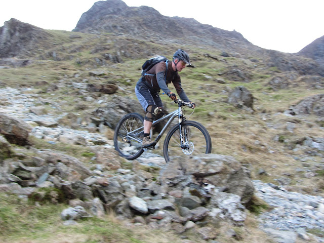 [/img]
I'll right a review at some point soon for Kingdom, but basically, big wheels, big forks and a compact frame coped with Lakeland rock fantastically when pointed downhill (except for pedal-clash)
But low BB/short cranks/single ring made climbing horrible. Its straining the distinction between AM/DH IMO
Note, we followed Boxelder's advise and went up the southerly route from Wasdale Head. Its a slog of a ride up the valley, then a carry. I'd be tempted to try the main route next time (as plotted), and just push up it.
Sorry
😳
The main drag's a pain.
