UPDATE: Reviews section refreshed, redesigned, searchable: Go take a look
Hopefully going up there on Sunday, will call in at the mtb centre but was wondering if any locals have got any route suggestions for something about 20 mile ish, got a longish journey so don’t want too much more.
I’ve looked on Trailforks and found Schoolmaster and the edge and also Edge and the gill.
Any suggestions greatly received.
dales bike centre has some routes on their site.
Just seen those thanks jonba
Edge and the Gill is a cracker (if it's the route that Stu from the Dales bike centre took us on)
Just don't go for a pie and a pint, beforehand - don't ask how I know this...
The Pinseat n Apedale route from the Dales bike centre is a good un. Nothing technical but a scenic route
I dropped you a PM with a route I did the other week which was roughly 21 miles.
Link fremington edge, the mine descent to gunnerside gill, and cross grinton moor to descend back to the bike barn.
55kish, best linkup there.
Thanks all, much appreciated.
This was my old route around Swaledale, not ridden it for years though...
Some of the long downhill sections have had gates added so they are no longer quite so fun as you have to stop every 500 yards. I suspect the gates were added specifically to slow down MTBs as they are popular walker routes.
[url= https://live.staticflickr.com/7843/40420731873_e80d0d9e18_c.jp g" target="_blank">https://live.staticflickr.com/7843/40420731873_e80d0d9e18_c.jp g"/> [/img][/url][url= https://flic.kr/p/24zQPme ]Swaledale Round[/url] by [url= https://www.flickr.com/photos/brf/ ]Ben Freeman[/url], on Flickr
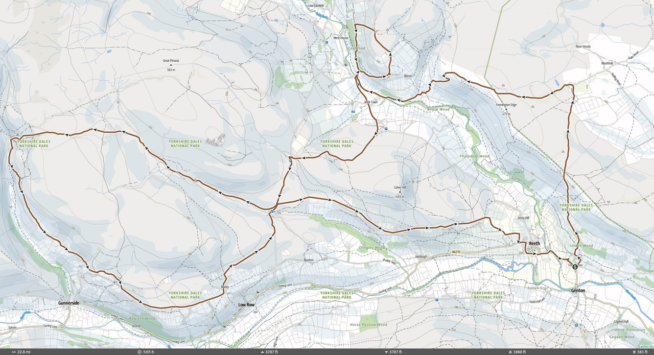
As others have suggested, Fremington Edge from Reeth, maybe turn left at the top and nip along the edge rather than drop to Hurst, then climb over to Pinseat, either take the quite gnarly BW direct into Gunnerside Gill, or there is a lovely descending footpath which rejoins the BW heading south. Then around to Low Row Pasture, BW descent to Gunnerside village, then cross the river and follow the Swale Trail back. Probably 23 miles or so, maybe 3500ft of climbing? Adding Harkerside/Apedale would make it a much tougher ride.
Some great ideas there folks and as an added bonus I’ve just found two Dales mtb guide books in my loft!
happy to send you a gpx (not 100% accurate mind as its sketched up rather than a track) but this would be my suggestion:
(caveat - I've not done the really short loop above booze in absolutely ages)
dangerbrain that’s a great offer thank you but I think I’ve got plenty to go on for now. Would you mind if I give you a shout at a later date if I need any info?
No trouble at all, just noticed I'd let it auto route me over the top of Gunnerside instead of down electric gate and along the tarmac or over the river and along the byway anyhow so I'd best revise that one
I grew up in Richmond so used to ride this area a lot. That descent down the end of Fremington Edge into Arkengarthdale in the route @dangeourbrain suggested was always one of my favourites so would definitely recommend trying to fit that in if you can.
Watching with interest as I can see there are at least two rocky gully descents off of Harkerside Moor that I'd like to work into a route.
Thread bump.
Is there anyone out there who can point me to the gully descents on Harkerside Moor, please?
No biggie if not - I'll probably be able to find them, but it might take a bit of trial and error and will be coming at the end of a pretty big day's riding, so definitive locations would be great. I assume they are bridleways?
Do you have Strava?
Use segment explore to find 'Pipeline descent' and 'High Harker Gully'. Those are the two obvious ones you'd do after a longer ride.
High Harker is fairly obvious on satellite imagery, and the turn-off for pipeline is fairly close to the start of that - segment called 'the right way' on Strava.
i did the Pipeline descent (Harker Top) on trailforks last month and it was excellent, steepish rocky and fast!
Joe m I’ve looked on Trailforks for the pipeline descent and can’t see it, what do you search for?
