Hi all,
I came across this photo in a thread on either here or Bikemagic - it looks great, I don't suppose anyone knows where it is?
[img]  [/img]
oh that's lovely 😀
I'm pretty sure I've seen that before, so must be from here, from a Superlight picture thread?
(alps if my memory services me... probably completely wrong)
[img] 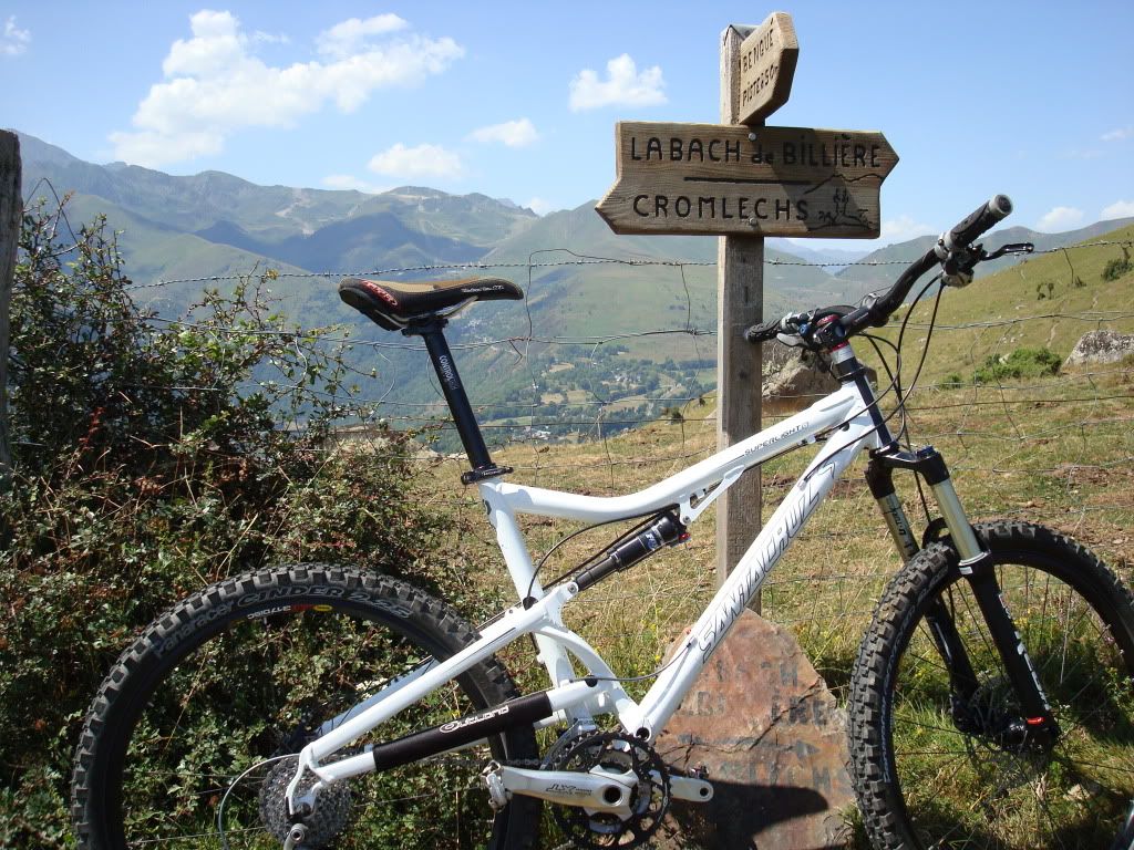 [/img]
Belongs to [url= http://www.singletrackworld.com/forum/profile/dave-vanderspek ]Mr Dave-Vanderspek[/url]
Originally posted on here:
http://www.singletrackworld.com/forum/topic/santa-cruz-superlight-2011-build
Though he doesn't reply to mention where it is, but is still active on here occasionally..
A bit of a stupid question - is there any way I can send a message to Dave to ask him? I looked high and low but couldn't see anything!
Hmm I was thinking alpine maybe? Dunno..
Clitheroe
Stab in the dark but my vote goes for above Meribel - French Alps
yep La Bach de Billiere is between clitheroe and waddingtonsamuri - MemberClitheroe
Pyrenees - somewhere around here?
Or Slaidburn.
yep La Bach de Billiere is between clitheroe and waddington
Although there is no evidence that the 2nd foto was taken on the same trip as the first one.
Thought so, the arrow pointing towards the camera definitely says Pendle so that proves it.
I thought it looked like the Ben Lomand track above Queenstown, NZ. Based on the above, I may be very wrong!
This appears to be his photobucket account - just commented on the pic asking him where it is.
http://s166.photobucket.com/albums/u97/chogs-280/
I hope it is the Pyrenees as I'm going there in summer 🙂
Llandegla.
Thetford has to be.
Watching this thread with interest. I do not think it's the Alps. Definitely not the UK!
pistonbroke - Member
Thought so, the arrow pointing towards the camera definitely says Pendle so that proves it.
It does? You talking about this pic here?

Looking at it in zoom mode, seems to be saying something along the lines of Bengue Piste, with what looks like a distance of I presume 50Km shown?
I must admit to a bit of a giggle at the sheer breadth of suggestions so far!! Mr Dave will be a popular man if we manage to get in contact with him.
Here's to hoping he sees the photobucket comment!
s60alex - Member
I must admit to a bit of a giggle at the sheer breadth of suggestions so far!! Mr Dave will be a popular man if we manage to get in contact with him.Here's to hoping he sees the photobucket comment!
I'm guessing it's somewhere between Iceland and Africa! 🙂
I'm with Dorkingtrailpixie for around Meribel, I have a photo from the 3 vallées vtt weekend a few years back and in the background the outline is very similar.
Unforunately, I don't have a photo hosting site so can't put it up
You think near the Tougnete lift, looking down the valley toward Bride Les Bains?
Could be
Looking at his photos,he doesn't spend much time in his garden LOL
ok will try this test to see if it fails, probably will
tried it and failed, I could send it to someone by mail and you can put it on here before someone else confirms it is where it is.
Ok, I've just found another photo and I can make out the Danger sign (by way of the shape). So I think I can say, yep 3 vallées.
capri - sign up for a free flickr account, or post em over to me & I'll throw em onto mine.
Locally it's pronounced 'La Bach de Billington', just off the arse end o' Pendle.
sent to your e-mail adddres z1ppy, cheers
Cromlechs is Pyrenees... whether the first pic was on the same trip or not, dunno but looks very similar terrain.
It looks to me like this was LONG 06 degrees 32' 00.0" E LAT 45 24' 15" N on Montagne de Cherrerie just north of a peak called Le Verdet.
Cabri's pic (you'll need to go to flickr to increase the size)
[url= http://farm6.static.flickr.com/5270/5789987811_02ba15744b.jp g" target="_blank">
[url= http://www.flickr.com/photos/15253377@N00/5789987811/ ]3 vallées[/url] by [url= http://www.flickr.com/people/15253377@N00/ ]z1ppy2[/url], on Flickr
[url= http://farm3.static.flickr.com/2688/5789988335_f85d193fd8.jp g" target="_blank">
[url= http://www.flickr.com/photos/15253377@N00/5789988335/ ]3 vallées[/url] by [url= http://www.flickr.com/people/15253377@N00/ ]z1ppy2[/url], on Flickr
Woods behind Nationwide in Swindon, shirley?
Thank you z1ppy,
If you look to the right hand side of the original photo on the thread, you will see the outline and to the left on mine.
Can't remember if it was before going down to Les Menuires or Meribel, whatever, there were quite a lot of singles, especially for an big organised outing.
[i]I'm with Dorkingtrailpixie for around Meribel, I have a photo from the 3 vallées vtt weekend a few years back and in the background the outline is very similar.
Unforunately, I don't have a photo hosting site so can't put it up [/i]
[i]You think near the Tougnete lift, looking down the valley toward Bride Les Bains?
Could be[/i]
That's the place, exactly - amazing piece of singletrack, went on forever!
I can't believe no-one suggested the STW usual:
"round the back of sainsburys"
EDIT: ignore this, i see the captain is here to uphold standards.
Second pic is the top of Benque Ridge above Luchon in the Pyrenees.
Don't recognise the first one though.
Without a doubt it's in the "Surrey hills"
Just to confirm this signed sealed and delivered, it's the trail above Meribel on the Tougnete side descending to Les Allues/Bride Les Bains, I am certain. The mountains in the background match the shapes of this trail on google earth exactly:
[img]  [/img]
Thanks a lot for this! Time to book some flights!!!!
I claim my cash prize then!
For a minute i thought it was the mountain mayhem course - but alas it looks dry !
Not England - because you're allowed to ride on it.
