Its raining, I'm bored so..
An easy one to start (be specific)
[img] https://lh3.googleusercontent.com/cr4HTEXNSiIsk_deWKx20IZ8jYFV7zpwwFp408A6Tfs=w940-h529-no [/img]
If you guess correctly it's your turn so have a suitable pic ready.
Pics of bike rides only, so must include a bike or something bike related.
Over to you.. 🙂
Is that them Surrey Hills?
That's too easy. Earth!
My turn...
[img]  [/img]
(yup, slow day in work 😀 )
😀 Both good efforts but wrong and not specific enough.
HAve another go..
FFS! Upper Earth.
Right, my turn again! (bit trickier this time)
[img]  [/img]
😀
Gale crater 8)
OOOH my turn again
right, really really easy one
[img] https://lh3.googleusercontent.com/CNPJwswHtlDNoQk6RNO_j1xCgirajVsorkrOGR81eKc=w904-h678-no [/img]
Right planet, wrong trail centre. It's the red run at Dingo gap 😆
Sorry twang, i live on a different island and don't know any of yours.
i live on a different [s]island[/s] planet and don't know any of yours.
FTFY 🙂
twang - somewhere near Capel Curig, looking to Tryfan?
Llyn Cowlyd?
Twang...(Top one) Lairig ghru? Possible from Breamar direction?
[img][url= https://c1.staticflickr.com/1/318/18560166322_f3180aa49c_z.jp g" target="_blank">https://c1.staticflickr.com/1/318/18560166322_f3180aa49c_z.jp g"/> [/img][/url][url= https://flic.kr/p/uh6GPC ]HT550 day 5 (21)[/url] by [url= https://www.flickr.com/photos/7582405@N08/ ]parkysouthlondon[/url], on Flickr[/img]
edit - damn flickr clues
Woods behind Nationwide?
ahsat - Member
Twang...(Top one) Lairig ghru? Possible from Breamar direction?
You are correct 🙂
boxelder - Member
twang - somewhere near Capel Curig, looking to Tryfan?
Llyn Cowlyd?
also correct and posted so ashat a pic please 🙂
...getting confusing already 😕 😀
EDIT; probably best not posting from flickr - Google pics works if you turn off Geo location in settings.
Carnmoreish
Tougher one from my neck of the woods.
[img] 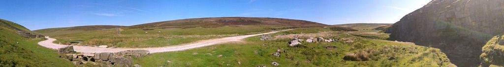 [/img]
Oh, all right, I'll wait a bit. Which one are we on now?
Oi! wait your turn Hutchy 🙂
[img] 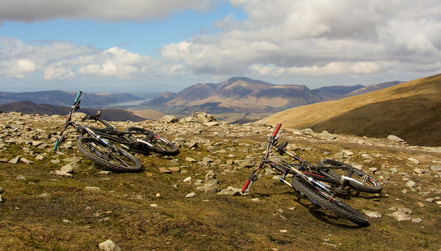 [/img]
Right, there we go! Was struggling to find ones without people in!
Needs more than just the general region!!!
Well played Ahsat, people allowed as long as its bikey.
Thats a toughy btw
Skiddaw from Hellvellyn......wait i'll find one
Well that near enough! Its from the ridge between Raise and Lower Man.
Well spotted Gallowayboy, you're in the chair...
Ooo I love a guess the location thread. Bring it on
Sadly the only one I have that's worth posting is this obscure trig point...
[img] http://Hardcast-FPS01\Users$\murray.chalmers\Desktop [/img]
doh[img]\\Hardcast-FPS01\Users$\murray.chalmers\Desktop[/img]
It's certainly obscure.
Give up......time to go out
Gallowayboys out.
Fresh start, first one up starts again.
Go!
[IMG]  [/IMG]
Frog Combe in the Quantocks?
Well spotted Gallowayboy, you're in the chair..
Twice, cos he got mine too.
Ooh! So close first time!
Cheddar Gorge area?
Grrr....thinking is got to be somewhere in that side of the hills. Hummmm, now looking for something with the slope the other way!
Its not Hodders, Stert, Sommerton, Ladys Edge. Dont think its Bin Combe (slope is the wrong side). Slaughterhouse (dont think we have ever found it correctly - we are from Newcastle!!)?
Horner Woods? Not sure which trail!
It's actually the very top of Stert.
[url= http://www.streetmap.co.uk/map.srf?x=314415&y=139247&z=115&sv=314415,139247&st=4&ar=y&mapp=map.srf&searchp=ids.srf&dn=725&ax=314415&ay=139247&lm=0 ]Hereabouts?[/url]
Jumps in with an easyish one to get the ball rolling....
[img][url= https://c2.staticflickr.com/4/3041/3620509774_a179e556d2_z.jp g" target="_blank">https://c2.staticflickr.com/4/3041/3620509774_a179e556d2_z.jp g"/> [/img][/url][url= https://flic.kr/p/6vW4qj ]IMG_0389[/url] by [url= https://www.flickr.com/photos/8827393@N05/ ]andytrousers[/url], on Flickr[/img]
Stert - ohhhhh!! It obviously wasnt as green in April. Nice. Now want to get back.
boxelder - Thinking somewhere around Red Pike - along that ridge to Haystacks.
Red Pike -
Bang on
This is making housework way more fun (i.e. not happen at all!)
Right, another from me then
[img] 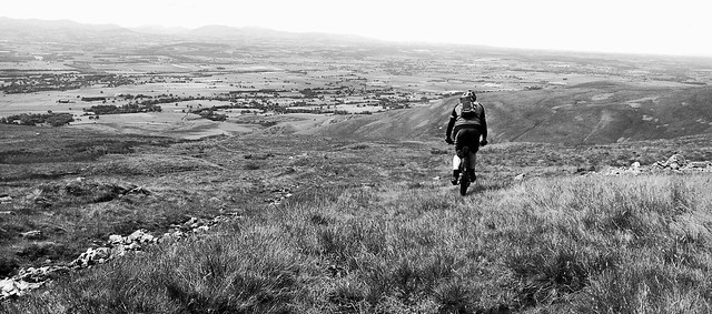 [/img]
North side of The Howgills?
EDIT - nah, too flat
Right region of England but wrong hills.
It's the Eden Valley I reckon, looking West - so High Cup Nick/Cross Fell.
Yup descending off the west side of cross fell. Good job.
[img] https://lh3.googleusercontent.com/DglzksbY1FXGT5YQR0nJnHREFFHl97TpKtRXHbRWcoM=w532-h947-no [/img]
