Forum Replies Created
-
502 Club Raffle no.5 Vallon, Specialized Fjällräven Bundle Worth over £750
-
 Steve_BFull MemberPosted 12 years ago
 [/url]
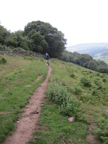
Ample looking north[/url] by steverb_11[/url], on FlickrNot done either recently –
Photo above was taken about 18months ago in Ample – it now takes about 15mins gate to gate going north!
 [/url]
Lochan Oisinneach Beag[/url] by steverb_11[/url], on FlickrThis is the outer loch at Ordie. Tho it can be very muddy in bits – its possible to do quite a lot on reasonable track which can be puddled but some it can be axle deep in mud in places – especially if attempting to find the best singletrack.
Might also still be a bit snowy around there
Steve_BFull MemberPosted 12 years agoWe have stayed just N of Porthmadog and about a kilometre away from Dolserau. For family holidays – beach, small walks,things to see both are good but for biking then nr Dolgellau has got to win out. For families you have the the Mawddach Trail – bike across the woooden bridge and get an ice cream in Barmouth. From were we stayed I biked small lanes across to Coed y Brenin for a mix of natural and trail centre. You also have easy access to Climax (and the Alternative energy centre for the non-bikers). The Pont Scethin circuit as one of the best natural routes you can do. Sustrans Route 82 with Cadair Idris on one side and the peninisula on the other is a fantastic road ride. The panaroma walk, and the precipice walk are superb for family walks. Cadair Idris as one of the best mountain circuits in britain.
Tho Harlech castle is superb, Port Merion is a good day out and Snowdonia is fantastic. But they are only about 40mins from Dolgellau.
Also worth noting is that Pandy has a garden – Tyn Llwyn has a fast flowing river – what age are your kids. If they are less than teen age that alone would decide it for me!
Enjoy – Wales is a fantastic holiday destination with kids – we were in Brecon this year with our youngest (who is now 24 !) and it was still fantastic.
Steve_BFull MemberPosted 13 years agoJust had one of these installed Esse 301
It is small at 5kW but it is mainly for chilly evenings and for extra comfort in the deths of winter and importantly it sits straight into the existing fire place – we have a victorian wooden surround and tiles that we didn’t want disturbed.
It is connected into the existing chimney – after it was swept and tested. No extra work to the chimney if it passes the test. Traditional fireplace needed throat removed and backplate fitted.
Cost about £1k for the fire and £1k to have fitted – which included a new slate hearth cut around the wooden surround.
Rather more expensive than I had intended. Finished Friday and not yet commissioned – so it had better be worth it!
There is a smaller one at 3kW but I think it only takes coal.
Steve_BFull MemberPosted 13 years agoWe were on holiday near Brecon in Jul/Aug. Biking was always going to be geared to how much of a mountain I could be persuade my wife to climb with a bike – and then muggins sheared a bolt on the rear suspension :-(
The routes on the link posted by timmys were in our house as route cards – as well as a guide book by Nick Cotton. We did variations on a couple – and the way we adapted them they both had a mix of superb desent a bit of tedious climbing, some hike a bike and fantastic scenery. The ones we adapted as a mix of the folowing routes and Cottons routes were
 [/url]
Crickhowell[/url] by steverb_11[/url], on FlickrI say adated as to be honest some of the routes I looked at seemed bizarre – far too much road or cycle path on any of the easier routes and Cotton routes seemed to cimb some cracking descents.
Keen to back and explore a bit more though.
A word of warning – you will definetely need a 25K map and way marking/bridleway signs were very intermittent on our circuit.
ps Nick Coton’s routes are available here if you wish a GPX eg classic-black-mountains-circuit
Although our rides were a bit hit and miss we ruled out the idea of driving an hour and half and paying £50 hire charge to ride on a “scalextric track” (and I do enjoy the Scalextric as well!)
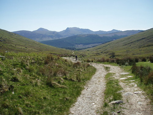
Steve_BFull MemberPosted 13 years agoI have done this a few times – beautiful glen. Wondered about the S-N climb as I have always done N-S – linked to Kirkton Glen.
http://www.flickr.com/photos/26693195@N03/sets/72157605268160139/show/
Suspect the descent of Kirkton might be a bit boggy at the moment tho and the sustrans route gives a good all weather alternative.
 [/url]
Descending Kendrum[/url] by steverb_11[/url], on Flickr
Steve_BFull MemberPosted 13 years agoNo end of forest tracks around Achray and L Ard – You might need to use them as the hill routes are likely to be very wet after recent rain. There is wonderful singletrack around David Marshall Lodge – some of it obvious tho much relics of former SXC races so not easy to find unless you can team up with a local.
Apparently you can also go up the track at Altskeith by L Ard and descend the hill path from Ben Venue – I haven’t tried it
The finglass route is old landy track OK tho tough climbing – you should be able to lift a GPX file of my Sportstracker page for some variations.
http://www.sports-tracker.com/#/workout/steverb_11/81igl9dgmuqc5t60For a longer outing it can be linked by going to Balquihidder and Glen Ample – which used to be heavenly singletrack but now a wide surfaced path. (The descent to Balquihidder is marmite – the only descent you need to do in granny gear so it is a love hate variation).
Some photos of a variation of the Menteith Hills circuit are here
http://www.flickr.com/photos/26693195@N03/sets/72157624937715111/show/
With a wee bit of exploring I ended up here
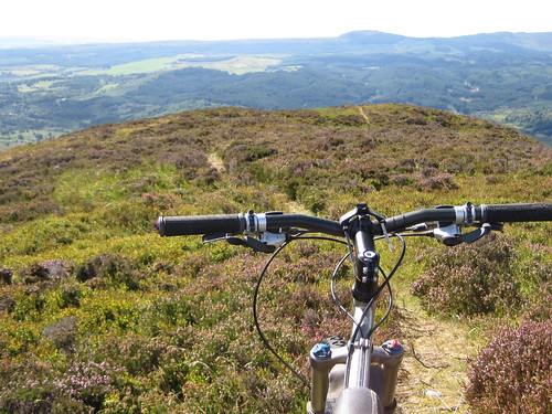 [/url]
Monievreckie nirvana?[/url] by steverb_11[/url], on FlickrThough it was over an hour of hike-a-bike!
And unless you are a biking god do Ben A’an as a walk without the bike – definitely worth it – central Scotlands mini Matterhorn! If you want a challenge can try climbing the minute slab at the top.
Steve_BFull MemberPosted 13 years agoNot ridden – but previously posted some links/info here
http://www.singletrackworld.com/forum/topic/trails-in-the-ariege-pyrenees
know exactly what you mean about the hit and miss – have experienced it in Vosges
Steve_BFull MemberPosted 13 years agoEtrex is no use. I want to log where I ride
Uhh – the basic etrex does exactly that – its what I use it for. Upload to Connect Garmin. If you wish you can then export to any mapping site that will take a GPX file.
http://connect.garmin.com/activity/81397694
http://www.sports-tracker.com/#/workout/steverb_11/b6k4j4pd3ahe8sbj
I never use it to follow a route. It has the advantage that it is tough, battery life is long and it gives OS co-ordinates for the occasions you might be slightly misplaced on your route
Need the newer H ones for decent reception tho – older one didn’t work in forest.
edit – too slow !!
Mine came with a USB cable so not the most basic then.
Steve_BFull MemberPosted 13 years agoGood Effort – though to Druidh – theres nothing worthwhile in Stirling – just keep heading North to the landy tracks and bogs :wink:
pop out on the single most stunning residence I have ever seen in my life.
Not a “Monarch of the Glen” fan then!
Next time Pete can ask people he knows for route advice !
Write up from the SBC site is here – with photos of what the Pattack circuit should have looked like :-)
http://www.stirlingbikeclub.org.uk/yabbse/index.php?topic=5399.15
Steve_BFull MemberPosted 13 years agoCarron Valley might be worth a look too
– eh? not from Arrochar – if you want a trail centre then Fire Tower at Lochgilphead is worth a shot – closer and a few fun bits. If you really want to drive as far as CV go to Aberfoyle or Stirling – lots at either location
Auchendrain is the best of the suggestions above – the final bit is not as good as it originally was but the outward route to L Awe is still superb. (Just need to watch you get the footpath off the ascent otherwise you will end up cycling on the forest drive)
We did Nick’s route around B Lomond as 2 seperate rides earlier in the year -first starting at Drymen – route as he described then hike a bike across Moin Eich to the Lomond tourist path and return WHW. The section thro the QE forest does require endurance of Sitka forest
Did the Gleann Gaoithe circuit starting from L Chon and going N to return along the road (40k for the whole circuit sounds a bit optimistic?)This is still track but at least it is mostly clear of the forest. NB The descent of the tourist path of B Lomond is well above a red trail standard tho so you might be walking some of the descent as well – some of our party were.
If you go through to Dalmally there is another classic circuit – tho rather a lot of road – go thro Glen Orchy and return across G Kinglass to Taynuilt (you can always get the train from there back to Dlamally to save the main road (tho you get free entry to Cruachan power station if you arrive by bike!) Also in KW’s book tho he does it a/clockwise
As for pulling a child trailer up the climb from Lochgoilhead on the Ardgarten circuit – no thanks :(
Steve_BFull MemberPosted 13 years agoYou will find lots of waymarked trails – just about every town has something – this site covers Western Vosges/Lorraine http://www.tourismevosges.fr/uk/vttpdf.php as we were staying near the lakes at Gerardmer though for tourism / wine and pretty villages Alsace is better to stay IMO – previously we stayed at Freland – some examples of Alsace VTT can be downloaded here http://www.tourisme67.com/circuits-vtt.htm
As MF implies above use the VTT routes only as a guide – they are not purpose built trails and if not careful you could easily spend the whole day on firetrack or descending on road – tho we did find some fantastic bits above Remiremont and also in the woods above the Voie Vert- you need local knowledge or a lot of time studying the 25K maps to get the best riding. There are not built berms and jumps – well not many – what you will get is a variety of footpaths and old forest tracks – often linking picturesque towns and villages.
Everywhere has Randonee routes marked with coloured signs and a little time spent pouring over the 25k maps will be well rewarded. Our best ride was a marked sentier almost from the door of the Gite with leg burning climbs and superb descents.
There is someone who posts on here with local knowledge – can’t remember who but a forum search may work.
Steve_BFull MemberPosted 13 years agoAndy – I would be keen to see what is in the area – email is in profile. Alison (who you met at Clova Hotel when you had to bail) is going up to this area shortly and looking for some new ideas.
Did see chatter about this ride but stuck to a route around Menteith Hills with SBC yesterday
Thanks
Steve
Steve_BFull MemberPosted 13 years agoFailing TK Max, we have used these guys for kit we didn’t have from other activities – can’t vouch for delivery tho http://www.skiwear4less.com/acatalog/Mens_Budget_Ski_Wear.html
Lidl are currently doing ski wear
Trespass are sometimes worth a look – though having said that I just bought cheap ski socks from them and took them back as they were pretty crap
Steve_BFull MemberPosted 13 years agoI would be interested in this as well as my wife is going up there shortly. I once went up there to follow a route in the Harry Henniker* book – I’m a bit wiser now! If you have time to go slightly further afield there is loads of good stuff out of Dunkeld and Pitlochry (and plenty of good advice from the local bike shop in Pitlochry)
There do appear to be plenty of tracks and dashed lines in the area so there must be some potential. I found this website a while ago – at least it gives some ideas
http://www.cyclehighlandperthshire.com/home/mountain-bike-routes/aberfeldy-kenmore–weem.aspx
* obviously a lover of firetrack in dense sitka forest – maybe the forest wasnt grown when he wrote the book since they are rather old
Steve_BFull MemberPosted 13 years agoHP – they own the car until its paid and if your circumstances change then you need to pay off the loan before you can get rid of the car
Bank Loan – you own the car, if you do it as a personal loan. If you then want to sell it, change it or whatever, you decide what to do with the loan
Cant see why either would affect you credit rating unless you seriously default.
Or buy a car for £4k :-)
Edit – like the buy another bike option
Steve_BFull MemberPosted 13 years agopolice will not be interested – even if money was taken – its between you and the card company. http://www.creditcardrefunds.org.uk/blog/fraud-victims-told-go-to-the-bank-not-the-police/
As said above if you have doubts cancel the card. Card company will block card if there are strange transactions – If you don’t want to cancel as you are about to go abroad get a cash card in case you do have to cancel or your card is blocked
Let the card company know you are abroad in case you do have to argue on odd transactions
If it is cloned you will get your money back as long as you report it quickly enough – tho its pretty stressful when it happens
Steve_BFull MemberPosted 13 years agoThe old one had been destroyed by tree clearance – didn’t realise a new one had appeared. If its near the original park at the carpark at Law Hill at the back of Dollar (follow signs for Castle Campbell, but keep going up the road instead of turning towards the castle) Then head into the forest on the N side.
Steve_BFull MemberPosted 13 years agoIn fairness the section in HH photos was a lot better by the time we did it and it had already eroded enough that the descents were good fun – tho I was never greatly sold on the riding in water up to your knees that was the previous experience on that bit.
The descent down to L Gainmaheach is a classic and I suppose every scottish circuit has a mind numbing climb somewhere. If you rattle it out quickly enough you can always nip down to the Firetower Trail for a play.
Steve_BFull MemberPosted 13 years agoWe were there in Sept – there is now a forest drive climbing from Furnace. The streambed section has been “improved” – its also easy to miss if you’re chatting away on the climb – as we were :roll:
Carron to L Awe was as I remembered it from my last visit – best bit now – photos here
http://www.flickr.com/photos/26693195@N03/sets/72157625040220846/show/
Climb back up from Durran was pretty mind numbing forest road (unchanged tho? – maybe just dismissed it from my memory) Just focus on nice views – or look at the forest drive across the valley and wonder who thinks driving through sitka forest is fun (maybe they were wondering why we were biking thro it :-) )
The finish from Leacan to Bralekan is the really sanitised bit – the rock fest has gone – tho it is a fast rough track and those who didn’t what was there before enjoyed it.
Not the classic it was – but still plenty of water (might be too much at this time of year?) and still fun.
Steve_BFull MemberPosted 13 years agoMatt – as a slight hi-jack – if you are that local is there actually a path from Dunan to the col – I’ve gone c/w and anti c/w and never found it – the route I followed is over the weir – as described by Alisdair.
PS I last did it in Feb 2005 8O tho my legs don’t hurt as much as my son’s who did on a bullit built as his first DH bike!
and the pain was captured here http://bigpaul.fotopic.net/c423534.html :wink:
Steve_BFull MemberPosted 13 years agoBen Chonzie should be OK for 3.5 to 4 hrs though it may have snow/ice at the top – there was still a fair bit of ice on the tracks around Kinnoull Hill in Perth at the weekend and its only 200m high.
At lower level there are various tracks out the back of Comrie Croft and a reasonable loop up through Laggan Wood towards Balmuick and on up to Braefordie. As your original query you can then head across to L Turret. Its scenic rather than challenging. If you park at Turret there is a route up onto Chionneachan and back that should be doable in about 4hrs – though it is a huge landy climb which is mostly demoralising pushing unless your fitter than most.
The Monument is good fun but will only take a few minutes – if you can ride the whole descent you’re a star (2 or 3 challenging corners) – but you may take out several families if doing at the weekend – its a popular walk.
The guys at Comrie are pretty helpful if you go in with a map. Drop them a few pennies for track development (honesty box from recollection)
PS I’m not sure if you’re intending the Croft trail to be an easy option for your better halves – I wouldn’t take my BH round it (tho she loves the Glen Garr trail referred to by islander. I would guess it really will be bog in several sections at the moment)
Steve_BFull MemberPosted 13 years agoThe OP s question was Fungle vs Firmounth – I think I have confused the topic :D
I have done it both ways but did Fungle ascent when it was s/t and waste of a carry
I agree descent N of M Keen is “ace” – tho not for everyone can deal with the rough eroded terrain!
Steve_BFull MemberPosted 13 years agoAlways gone by Fungle to include the singletrack near the end of the descent. Firmounth is shorter – tho the initial climb from the split goes 100m higher but then there is more rise and fall on Fungle.
If you are fit enough to do the circuit then the extra 10k won’t be a problem – Fungle down to Birse Castle (and beyond)is now a surfaced track so fairly fast. Just watch you don’t miss the s/t path. The extra distance back to G Tanar is easy pleasant riding.
This assumes going anti-c/w – going c/w I would probably consider climbing Firmounth rather than the steep built path on Fungle. No doubt other more local opinions will be along soon.
Steve_BFull MemberPosted 13 years ago@ Marmoset
I’m fortunate that i can ride an abundance of trails and hardly meet a soul but I have found that a road bike and mixed use trails are not a good combination – you are probably doing 12-15mph on an MTB and slow to 6-7 whereas on the road bike you’ll easily do over 20mph so “slow” is still fast to walkers – as I have also found out
Most folk in a group are pretty oblivious to others regardless of activity (try going round a busy trail centre as a solo rider and see how much attention the groups are paying to other riders! and theres frequently an @rse in those groups as well* – maybe we just all need to chill a bit
* like the guy(on a bike) at Glentress that told me I should have a bell – my moment of the year
Steve_BFull MemberPosted 14 years agoHouse insurance will cover it whilst in halls (well M&S Premier does)
Gets more complicated if in a flat – espec if shared with others – when AWH prob has the best solution
Steve_BFull MemberPosted 14 years agoHi Jamie
We went to Ariege this year. We didn’t have bikes as the idea was to do a bit of walking/sightseeing but I was suffering withdrawal symptoms 8)
Don’t know how well you know Ariege – we were staying in Lavelanet – which is not at all a tourist destination and probably wouldn’t choose it again but it was really accessible to mountains, coast and historic towns – Foix Mirepoix Carcassonne etc.
Despite being a very ordinary town there was uplift at the local ski area – Mont d’olmes with a variety of DH tracks and also a network of waymarked routes.
http://medias01.enjoyconstellation.com/e15b3b24-07cf-41ae-bb52-28bcbb9ef720_134.PDF
We ended up on foot on some these and like trails we have ridden elsewhere in France they were a mixture of really overgrown/surely this is waymarked the wrongway/ bloody brilliant
Foix would have been the nearest tourist town – easy access from Toulouse airport – on the motorway to Andorra and still access to coast within a couple of hours. From there there is also a network of trails to the north
http://medias01.enjoyconstellation.com/58dd23c9-08f2-4bf9-85dc-227ed7bdd7ce_134.PDF
and to the south at Ax de la Thermes
http://www.vtt-vallees-ax.fr/www.vtt-vallees-ax.fr/images/planAx092.pdf
Ax de la Thermes also had gondola uplift and more full on looking downhill – judging by the bikes and gear anyway :D it also gives easy access to lots of fantastic towns and scenery.
Don’t think you will go wrong anywhere in most of Ariege – Though N of Lavelenet (Montbel – Mirepoix) is pretty but flat biking only and as elsewhere in France it would be worth getting the 25k maps with Randonees routes marked to read with any VTT waymarking.
PS Brilliant destination – but in July/ Aug we had real British weather with a good mix of rain, low temperatures and brilliant sunshine – so pack waterproofs and warm clothes!!
Steve_BFull MemberPosted 14 years agoFinally, there’s a path marked from the mast at An Suidhe (south of Pitlochry) up to Creag a Choire and back through Clunie Wood – is this worth a punt
Yes – short but sweet – steep climb to get to the mast, moorland path to the treeline and then fast descent in Clunie Wood – tho last time we were there – a few weeks ago there had been tree felling and it was a bit a mud bath in the forest
Usually do at as a “warm up loop” before tackling the Fincastle side
I havn’t tried the Tenachry option (or the Vrackie side) yet sounds like a couple of good variations
Steve_BFull MemberPosted 14 years agoI used the Nokia Sportstracker and have now have the new version but have been unable to upload to the website – apparently I cycled to somewhere off the coast of Africa.
The new site is very nice – but may now look at some of the others now.
In terms of battery use I tracked a full day at GT on the Beta version on all the routes there and had no problems – tho I never use the phone for tracking when on remote rides in case I need it to summon mountain rescue when I run out of food :wink:
Steve_BFull MemberPosted 14 years agohere I was thinking all those hits meant I was popular!
Double jeopardy. Your own collection would have to be lost AND the Flickr servers down at the same time…..
Happened to me with a fotopic account – their server lost some pics and when I went to restore them I had also lost them as when I had first used a digital camera the software had dumped them in an obscure applications folder which I hadn't backed up – tantalisingly the thumbnails are still on fotopic
Lesson learnt!
Steve_BFull MemberPosted 14 years agoStill 3 available here
http://www.monzievaird.co.uk/holidaycottagesprices.cfm
Has the loch – equidistant between Crieff and Comrie so beautiful walks – and Comrie Croft on the doorstep for a quick spin
We started going for Christmas away about 20 or so years ago and this did us broud for a few years – hardly cheap mind you
Other wise google "cottages 4 you" it has a good range of prices and locations – thats who we normally manage to book through
Steve_BFull MemberPosted 14 years agoWorth a visit if you're in the area – but you'll need to do a lot of laps to occupy you for half a day. Trails arent armoured so more of a "natural" rooty techy feel but means some bits can be a bit more muddy than the GT crowd are happy with. Graded as a red but a couple of steep chutes are more like some of the Drumlanrig black
There are other trails in the area – though apart from one or 2 bits are more scenic than technical – the guys there will give you some ideas
Steve_BFull MemberPosted 14 years agoTa Shandy – I've also had it confirmed from another source that the wheels should still be there when we get back :-)
Steve_BFull MemberPosted 14 years agoBringing up again – Any Norn Iron travel knowledge out there ?
Steve_BFull MemberPosted 14 years agoYou can take from that advice that the first trails you should be checking out are the dashed lines with red highlighting…
Thats the way we found our best riding – tho GR routes had good terrain as they were footpath in scale if not in access :-)
or perhaps the OP is mixing up terms between randonee and GR
Pawsy_Bear – if if you look at Stevomcd link and follow the VTT links you will get GPS http://www.ffc.fr/a_VTT/a_SitesVTT/TRACE_GPS.asp but you wont get the path / track distinction that he highlights that you get from the map
(or you can go and hoiday with him – or others on here – and save alot of toiling over maps)
Steve_BFull MemberPosted 14 years agoIs this what you are after
http://www.gr-infos.com/gr-fr.htm
French mapping does not easily distinguish footpaths from farm tracks – Everwhere has VTT maps so it is worth a bit of googling – tho we have learnt that even black VTT routes can be on good forest roads! The 50k mapping is no good for this – the blue 25k is better but needs a good bit of study to try to get the best out of the route.
Steve_BFull MemberPosted 14 years agoor better size here
http://www.geoportail.fr/?c=7.3583,48.24166&l=Scan(100)&z=7
ps thanks frn – been trying to remember the name of that site!
Steve_BFull MemberPosted 14 years agoJust done a forum search for the same info as the OP! (assuming youre not the same John as I was out there with!)
I have been up there a few times – there are some good rideable tracks – mostly double track and some old deteriorated tarmac road. There is a also the odd bit of more interesting track in the woods around Comrie – but short and difficult to fit into a bigger loop. Unfortunately what is shown as s/t on the 50K map is not. You can loop in with some good and scenic riding out Glen Artney and FIndhu Glen (tho I have heard that some of the locals are less than welcoming so be prepared with your charm!)
Scenery is terrific and Comrie Croft is worth a visit if you are in the area.
There are new tracks above Braefordie – with all the character that new tracks have – but its still out there and I'm also curious about a possible descent off Ben Chonzie across Carn Chois to W of Turret
The circuit of Choinneachain to E of Turret is steep landy track (a long hard push for most) with a rough track descent. Nice views and good miles but nowt technical.
Comrie & over to Ardeonaig is OK to tick off – its tarmac to the far end of Lednock reservoir – we found no sign of the marked track so there was the heather hag push carry to the shoulder and a nice but short descent to the loch.
Again on the return through Almond there is (or was) no sign of the marked track. This bit I have done several times c/w and a/cw and found the best way is to push up the steep track from the dam to were it says Dundornie on the map – though what looks like a flattish push carry on the map is still v difficult!
Steve_BFull MemberPosted 14 years agoNoooo – this cannot happen
Tracks around Stirling have had this treatment – also tracks above Perth (Kinnoull Hill) – I don't know anyone child or adult , biker or walker who thinks it is an improvement. The paths lose all character and interest and are often made too steep for those who may need or prefer a better track for access Glen Ample is a disgrace.
Do you have the access officer details ? If so Please post contact information for PKDC to allow others to voice their opinions.