Going to South Wales at half term with the Kids looking at riding the Gap. Just need some advice on which one you would take and why
The one on MTB Wales
 MBWALES.COM
 or
Cant see the alltrails one but I've always done the MBW one.
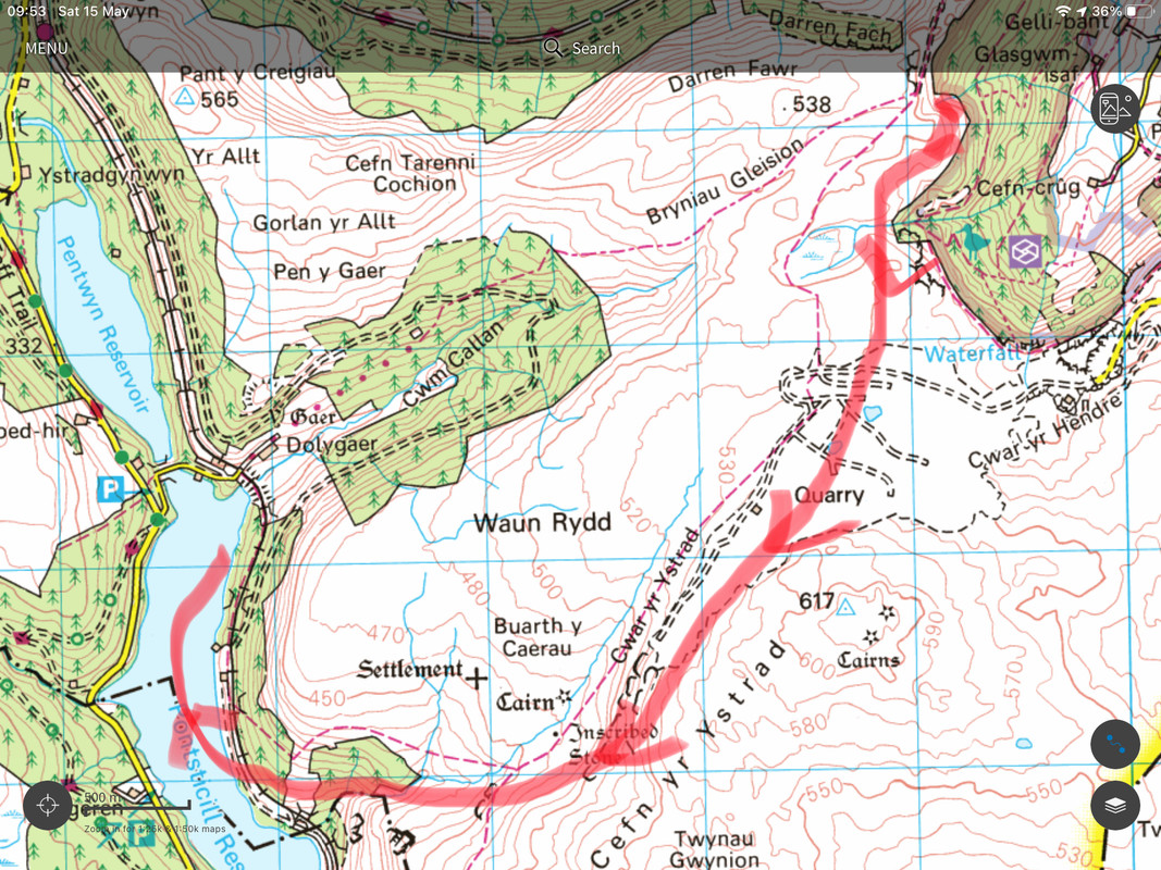
Only difference is after the big descent from the Gap heading North, after the gate I take the track to the right which goes down a gully / ditch, wiggle down the road a bit, then take the bridleway down the field. Comes out same place, but a bit less road.
Dropping down to Pontsticil gives you a bit more climb after Talybont res, descent, then a draggy road climb to get back on the Gap road. Not a whole lot further but feels it!
If your legs are good after Talybont, go for it, but it doesn't add much quality wise to the route IMO
Surely you have to go all the way to Pontiscill to do it properly? Love the Merthyr vibe and the chance for an ice cream at the steam railway.
I generally follow the narrow track described by 40mpg, then descend to Llanfrynich the same way as the alltrails route. Looking at the OS map, that's the track coming out at Tir-ciw, then follow the route of the Three Rivers Ride past Tynllwyn.
The MBWales route via Breco might make sense if you're starting/finishing there, but even then I think I'd do route above and get to Brecon via the tow path.
I don't know the route well enough to comment between the two, but whatever you do, go UP the fire road climb and Down the rocky side, not the other way around as some friends of mine did a few years ago.
Thanks for the advice.
Looks like the rail way is closed, which is a shame as that would have worked out nicely
Personally I would do neither route but a hybrid of both with some cheeky extras thrown in. However, it might be a bit full on as a day out for kids. It would pass the station cafe though for ice creams 🙂
Do you have a GPX. both kids are quite use to long hard days in the saddle having ridden the West highland way, South Downs way etc
I can knock one together for you. I haven't ridden that route for the past couple of years though so can't guarantee all options still work as they used to.
That would be great if you could
The All Trails route is the one I use the most, except I don't always take the bridleway option at 21.7km (as you hit the first bit of road after the Gap descent) as the farmer has a habit of not keeping it clear. You only find that out a few hundred metres down as it can turn to a wall of brambles and nettles! The issue is that the road alternative takes you past his farmyard and he doesn't keep his dogs controlled so they can chase you down the road and try and nip you - the police have been aware of it for years but he never changes.
Also don't take the road back to Talybont when you get to Pencelli, drop o to the canal towpath instead. The Red Lion is good for refreshments at that point too.
@welshfarmer - there's been a lot of forestry work up there the last year or so, some trails are useless or now boring fireroads again. Can't remember exactly which ones but the two Taff Trail loops are closed and one of the fun alternative tracks that was a fireroad but had turned into a lovely singletrack blast has been opened up again. Happy to take a look at your GPX route and check it if you want?
Not true about the dogs in the farmyard that you pass through on the tarmac route back down after the gap descent. I do this a couple of times a month, have done for several years (live locally) and have never seen the dogs loose there. They are always chained up or in the sheep trailer, which is a bloody good thing as they go mental when you pass. So, as far as my experience goes anyway (and I do this route a lot!) is not to worry about dogs. Can be a problem with cows on the trail back down at the Neuadd end of the gap road though. Farmer feeds them on the track and they make a terrible mess, cut the track to pieces and trample into deep mud. Funny how they banned 4x4s off what was a permissive route because they said they do too much damage but let the farmer absolutely wreck the surface feeding cows on it.
The All Trails route is the one I use the most, except I don’t always take the bridleway option at 21.7km (as you hit the first bit of road after the Gap descent) as the farmer has a habit of not keeping it clear. You only find that out a few hundred metres down as it can turn to a wall of brambles and nettles!
I’ve always gone that way & yeah it can be a bit wild but it’s still rideable.
Has anybody done this route this as a descent?
