UPDATE: Reviews section refreshed, redesigned, searchable: Go take a look
Pistonbroke - 25lb!? does that include the kitchen sink!? 😉 Is the route you're referring to near a couple of windmills?
pistonbroke does it link SN837793 to SN773790 ?
Stuart
Quite possibly but there are a lot of windmills around this area. Re weight, a chap needs a few home comforts 😕
so you're not going to just give it away for the general good of the population? 😉
streetmap seems to have a newer maps than my copy of memeory map (maybe 5 year old).
the windmills and tracks are shown on SM but not on my copy of MM.
so you're not going to just give it away for the general good of the population?
trouble with doing that is that we then end up all doing the same route... I don't know where this route is but I intend to pour over the 1:25000 scale maps, google earth and geography.co.uk this weekend 🙂
Did a dry run at the weekend, not over the route just local to me. Judging by the time and distance covered I will be doing well if I can get 10 check points 😯
True enough. Google Earth and geograph are ace for route planning. I'm really excited about this. Shame I can only do one night.
Track isn't shown on any version of MMap,Geograph or Google Earth but I have found a photo of it... Keep guessing, now I'm torn whether to disclose it, my initial thought was yes as after all it's not a race. Stuart is pretty warm but he should be after all 😉
hmmm... the plot thickens. is it on the latest version of OS data, ie streetmap or OS get-a-map?
Just checked on get a map and no it isn't. I'll give you a clue, it was used on the Wales Rally GB last year.
So it's not on any map, not visible from space and there might be a picture of it on the web somewhere (amongst several million), this might take some time...
(waving hand furiously)
FOUND IT
2nd.
I didn't say it wasn't visible from space, the latest Google Earth photo is 3 years old and it has been built since then. OK flatfish what are the heights of the start and finish of the track running west to east?
Please sir it's 1243ft-1624ft
In meters please and show your workings.
I have an real inkling of where it is... but cannot find the fabled picture......
Its on geograph titled
There I've said it.New Track at Cefn Croes Wind Farm
Ha ha, was looking at that picture just the other day... duh!
I've found a map of it!! ;-p
where?
Do you work for the Forestry then or have you got the original plans for the wind farm?
rally maps has google maps of all the stages...
Clue: the Wind farm.
There is a bloody big track/road visible in the google maps satellite view
just been looking at the map, I don't really think it gives that much benefit.... wel not on the route I've worked out. ;-/
As Nick said earlier, it would be boring if we all went the same way. I've just had another look at the Google Map satellite veiw and it isn't on my version still. Just to be clear it runs from just east of a run down farmhouse contouring up Draws Drum and across Banc Dolwen, leaving the forest at 803791 and across to the turbine road, it is definitely the most direct and least climby route between the 2 bothies. But what do I know, I've only been riding in these hills for 30 years.I remember when it was all fields. I'll shut up now.
But what do I know, I've only been riding in these hills for 30 years.I remember when it was all fields
bollokcs to what I said, I'm following you 🙂
fair play pistonbroke, you know the area so am not doubting you. Everyone's route will be different as that's just human nature, and what makes this an interesting and fun event. 🙂
I'm only able to do 1 night and 2 days riding, so have plotted a route around 10 checkpoints. Whether I get them all maybe doubtful..... from my previous experience in this part of wales, bridleways tend to have a time-sapping dimension not present in other parts of the country. 😀
In this part of Wales the locals call that "Welsh Time" ... You think you know what time it is, then when you look it's 3 hours later than you thought. It doesn't happen in winter though only summer months. It'll be the reason I never manage to get my tea until 9.00pm 😉
Stuart
Two general questions:
1) how much % road have you all got in your routes, roughly?
2) anyone doing it singlespeed?
1)Road? Are we allowed to use the road?
2)Does pushing count as singlespeed?
Sensible answer 1)About 30% 2)Not me, I've ridden with people on singlespeeds in this area and its not pretty.
There are indeed single speeds taking part ... with the right ratio they'll be fine 😉
Anout 30% very quiet (I hope) road here, but 120 miles over 48 hours I fancy gears and full suss over rigid single speed.
As it's not a race so it's comfort and an enjoyable time for me.
Don't worry any roads will be quiet ... it's not uncommon for me to ride all day (8 hours +) and not meet a sole 😀
Aye you're right John it's about enjoying the journey ... shame though as I was looking forward to a go on your Jones 😉
I fully intend to enjoy myself, even if I decide to do it on the singlespeed 🙂
What's the consensus on the bridleway that goes through checkpoint 12?
I've not ridden it, but I recall a mate telling me he had, and it wasn't pretty...
my favourite bit from last year, beautiful it was/is.
Come on give us WRT virgins more info about the "bridleway that goes through checkpoint 12"
took a lot longer than i was expecting.
[img] 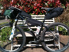 [/img]
all kitted out for a trial run this weekend, about 100 miles with wild camp.
Oooh Checkpoint 12.... yes I have memories. well more like Flashbacks.... don't expect dry feet. 😉
My short route is 35% road. and 20% pushing.....
Flatfish, that looks like a great set-up. What frame bag and seat pack is that?
jandd frame bag which i found a lot cheaper online from utah(shop rans) than from jandd themselves and the seat pack is from Epic designs in alaska, not cheap.
From a different angle,
[img] 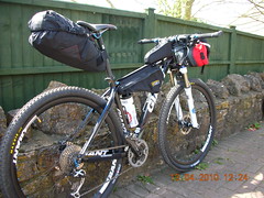 [/img]
"bridleway that goes through checkpoint 12"
You take the low road, I'll take the high road and I'll be at the bridge afore ye. Again another track which isn't on the 1:50,000 but is on the 1:25,000 will be your friend.
Giving all your secrets away, you are! 😀
there are some nice sections of singletrack on that bridleway down the valley.
