Blanchland & Edmunbyers, two of the finest bits of singletrack. 19.5miles, 1934ft climbing. Bit windy, but dry and fast 😀
[img][url= http://farm7.static.flickr.com/6155/6182119629_6568dbf84b_b.jp g" target="_blank">
[url= http://www.flickr.com/photos/66452821@N00/6182119629/ ]Edmunbyers & Blanchland[/url] by [url= http://www.flickr.com/people/66452821@N00/ ]ritcheyp20[/url], on Flickr[/img]
[url] http://connect.garmin.com/activity/116944578 [/url]
116 mile round London sportive. 1500m climbing
MM
P20 where you from? thats near me, love that bit on blanch land moor and the track that is in the top left of your map running west is also great.
😳
(I was in a rush, okay)
[url= http://farm7.static.flickr.com/6175/6182806962_38a1429c44_z.jp g" target="_blank">
[url= http://www.flickr.com/photos/23823661@N05/6182806962/ ]christiwasfast[/url] by [url= http://www.flickr.com/people/23823661@N05/ ]scaredypants[/url], on Flickr
(a throbbing 643 feet of ascent)
Penmachno 1 & 2
[IMG] 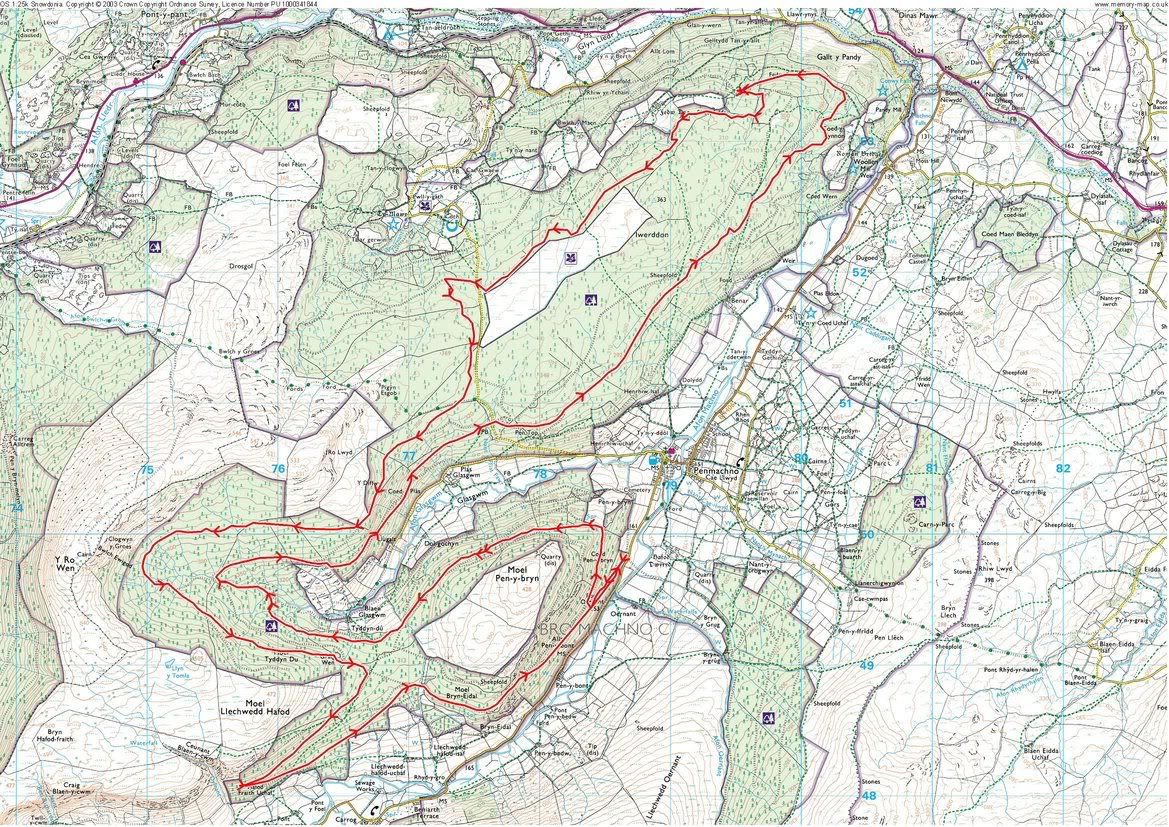 [/IMG]
Blanchland/Edmundbyers was one of the 1st routes I ever did, about 20 years ago! Haven't done it for about 7-8 years now.
The names are all coming back from that area, Pennypie House, Embley Fell, Ladle Well, Hangman Hill, the Broadway, Sinderhope Carrs (cheeky), ahh, memories.
Is that track from Baybridge to Riddlehamhope a bridleway yet? cos it should be!
[img]  [/img]
...didnt make it out, feel like the guy above.
essel - me too! on an old apollo when i was a kid and my dads friend took us out!
[IMG]  [/IMG]
Mostly Crank It Up, Freight Train and A-Line for me yesterday 🙂 Lifts to the top, obviously.
We live in Ebchester, so it's only 7miles.
agentdagnamit - Member...didnt make it out, feel like the guy above.
I did get out and i look like the guy above.
Much work to do over the next year!!
Did some yomping over the Basque countryside, shins full of thorns but well worth the pain...
Friday
[img]  [/img]
Sunday
[img]  [/img]
Elev. a bit off though.
I can't figure out how to put a picture of the map up, but here's what I did today: http://www.mapmyride.com/routes/view/51998144/
Met some STW-ers (hi P20 and Ahsat!) and generally had a lovely afternoon out on the moors!
Not sure I'd do the trudge up to Bolt's Law again though - seemed like a lot of hard work for a very meagre downhill, although it was a nice view. The trail across Edmundbyers Common, however, was ace!
[url= http://farm7.static.flickr.com/6154/6183059132_099179cd8f.jp g" target="_blank">
[url= http://www.flickr.com/photos/legolam/6183059132/ ]Bolts Law[/url] by [url= http://www.flickr.com/people/legolam/ ]Legolam[/url], on Flickr
Small loop around Ben Nevis with a bijoux amount of climbing and 4 trips to and from the campsite. About 80 km I suppose. Too tired to work out how to do a map thing.
how do you post the 1;25000?
would love to know!
Blasted out to town on the singlespeed for some Oktoberfest Erdinger in Tyne bar yesterday and met my mates Fixie crew.. then today was a blast to get a feel for my new gatorskins..
feels sweet.
A mere 20 km, but quite hilly with ~800m climbing and descending.
[img]  [/img]
apologies for likely needing to know the areas a bit better than what below shows
[img]  [/img]
25.4m
[img]  [/img]
16.4m
Both made of bits of V graphics routes and 'the good mountain biking guide'
A little pootle around Ben Nevis 😉
[url= http://share.abvio.com/2acf/78e4/4cfa/c5a5/Cyclemeter-MountainCycle-20110924-0932.kml ]Tour de Ben Nevis[/url]
my first ever proper trails around delamere
edit
sorry guys problem with loading image
Saturday was lots of laps of Laggan. Sunday I haven't a clue where I've been. Rothiemurchus and general vicinity
I've used a screen shot of memory maphow do you post the 1;25000?
would love to know!
Bit slow I know but it was a nice ride in the hills
http://connect.garmin.com/activity/116844487#.Tn7xli10Mew.facebook
I rode this route pretty much but missed out the furthest descent and ascent preferring to just go straight up to the top of the hill and back..
I also rode the cheeky pheasant pens twice and added a couple of easy road miles at the start and finish..
pooped.. 😀
[url= http://connect.garmin.com/activity/111532987 ]http://connect.garmin.com/activity/111532987[/url]
[img]  [/img]
(linked to foxyriders garmin data from an earlier thread)
Yesterday's east Dartmoor ride...only 14 miles but 840m of climbing, with some sessioning mixed in on the descents (not by me, I was too knackered!)
[url] http://connect.garmin.com/activity/116989210 ][/url]
yunki what software have you used for that attractive and informative graphic? Thanks in advance
What is the best free website/program for mapping your routes?
did a nice 50k over scout moor, crag & lee quarries and back over holcombe, with 1200m climbing - be good to record it somewhere!
lipseal - I just borrowed the data and graph from this [url= http://singletrackworld.com/forum/topic/stw-forum-ride-east-dartmoor-3911 ]thread[/url].. I think foxyrider explains how to create the graph if you clicky..
orena45 - your link isn't working.. there were a few out and about on East Dartmoor yesterday.. perfect afternoon for it.. I imagine I passed you en route somewhere..
[url= http://www.pixelfire.co.uk/images/gaick_feshie_tilt.jp g" target="_blank"> http://www.pixelfire.co.uk/images/gaick_feshie_tilt.jp g"/> [/img][/url]
Rode Blair Atholl – Gaick Pass – Glen Tromie – Inshriach for cake 🙂 – Glen Feshie – Geldie Burn – Glen Tilt – Blair Atholl over two days at the weekend.
Superb trip.
http://connect.garmin.com/activity/117026990
Up until my Garmin died.. overall ride was 14 hours !!!!! in the dark !!!!
I'm tired....
3500m of climbing... or 11,000 feet !!!!
[IMG]  [/IMG]
33 miles in total
[URL= http://img94.imageshack.us/img94/5893/screenshot20110926at140.pn g" target="_blank"> http://img94.imageshack.us/img94/5893/screenshot20110926at140.pn g"/> [/IMG][/URL]
Set out but lost the love so turned back before I got to where I wanted to go
[img]  [/img]
Debaser, nice route. I've got some happy memories from rides around there
yunki - What'd you use for that image?
atlaz - look at my post ^^^ up there in the middle of the thread somewhere.... 😉
