Forum menu
As the crow rides.....
 

[Closed] As the crow rides...

Posts: 5182
Free Member
Topic starter
Translate
English
Spanish
French
German
Italian
Portuguese
Russian
Chinese
Japanese
Korean
Arabic
Hindi
Dutch
Polish
Turkish
Vietnamese
Thai
Swedish
Danish
Finnish
Norwegian
Czech
Hungarian
Romanian
Greek
Hebrew
Indonesian
Malay
Ukrainian
Bulgarian
Croatian
Slovak
Slovenian
Serbian
Lithuanian
Latvian
Estonian
 

Is there a route planner that allows to plot a line between points on a map, and then generates the shortest route between the A and B (or A, B and C etc) using road/byway filters?

ie I want to travel between A and B yet, using primarily minor roads, or minor roads and bridleways, or minor roads and b roads etc


Posted : 28/09/2019 2:03 am
Posts: 5182
Free Member
Topic starter
Translate
English
Spanish
French
German
Italian
Portuguese
Russian
Chinese
Japanese
Korean
Arabic
Hindi
Dutch
Polish
Turkish
Vietnamese
Thai
Swedish
Danish
Finnish
Norwegian
Czech
Hungarian
Romanian
Greek
Hebrew
Indonesian
Malay
Ukrainian
Bulgarian
Croatian
Slovak
Slovenian
Serbian
Lithuanian
Latvian
Estonian
 

https://www.cyclinguk.org/journey-planner#

Just found this, anything better that converts to GPX? Unless I’m missing something..


Posted : 28/09/2019 2:19 am
Posts: 0
Free Member
Translate
English
Spanish
French
German
Italian
Portuguese
Russian
Chinese
Japanese
Korean
Arabic
Hindi
Dutch
Polish
Turkish
Vietnamese
Thai
Swedish
Danish
Finnish
Norwegian
Czech
Hungarian
Romanian
Greek
Hebrew
Indonesian
Malay
Ukrainian
Bulgarian
Croatian
Slovak
Slovenian
Serbian
Lithuanian
Latvian
Estonian
 

https://www.komoot.com/plan/@53.6312034,-2.4966431,12z?p%5B0%5D%5Btype%5D=highlight&p%5B0%5D%5Bid%5D=222003&p%5B1%5D%5Btype%5D=highlight&p%5B1%5D%5Bid%5D=611439

An option.


Posted : 28/09/2019 3:25 am
Posts: 0
Free Member
Translate
English
Spanish
French
German
Italian
Portuguese
Russian
Chinese
Japanese
Korean
Arabic
Hindi
Dutch
Polish
Turkish
Vietnamese
Thai
Swedish
Danish
Finnish
Norwegian
Czech
Hungarian
Romanian
Greek
Hebrew
Indonesian
Malay
Ukrainian
Bulgarian
Croatian
Slovak
Slovenian
Serbian
Lithuanian
Latvian
Estonian
 

That Cycling UK one is based on Cyclestreets. If you use it through the Cyclestreets website, it has an option to export to GPX. https://www.cyclestreets.net/


Posted : 28/09/2019 8:57 am
Posts: 5182
Free Member
Topic starter
Translate
English
Spanish
French
German
Italian
Portuguese
Russian
Chinese
Japanese
Korean
Arabic
Hindi
Dutch
Polish
Turkish
Vietnamese
Thai
Swedish
Danish
Finnish
Norwegian
Czech
Hungarian
Romanian
Greek
Hebrew
Indonesian
Malay
Ukrainian
Bulgarian
Croatian
Slovak
Slovenian
Serbian
Lithuanian
Latvian
Estonian
 

Top notch thnks 👍🏼


Posted : 28/09/2019 11:41 am
Posts: 13282
Free Member
Translate
English
Spanish
French
German
Italian
Portuguese
Russian
Chinese
Japanese
Korean
Arabic
Hindi
Dutch
Polish
Turkish
Vietnamese
Thai
Swedish
Danish
Finnish
Norwegian
Czech
Hungarian
Romanian
Greek
Hebrew
Indonesian
Malay
Ukrainian
Bulgarian
Croatian
Slovak
Slovenian
Serbian
Lithuanian
Latvian
Estonian
 

Thanks for the cyclestreets link. Never heard of it before but it follows the routes I'd take locally so looking forward to trying it elsewhere.


Posted : 28/09/2019 12:35 pm
Posts: 5182
Free Member
Topic starter
Translate
English
Spanish
French
German
Italian
Portuguese
Russian
Chinese
Japanese
Korean
Arabic
Hindi
Dutch
Polish
Turkish
Vietnamese
Thai
Swedish
Danish
Finnish
Norwegian
Czech
Hungarian
Romanian
Greek
Hebrew
Indonesian
Malay
Ukrainian
Bulgarian
Croatian
Slovak
Slovenian
Serbian
Lithuanian
Latvian
Estonian
 

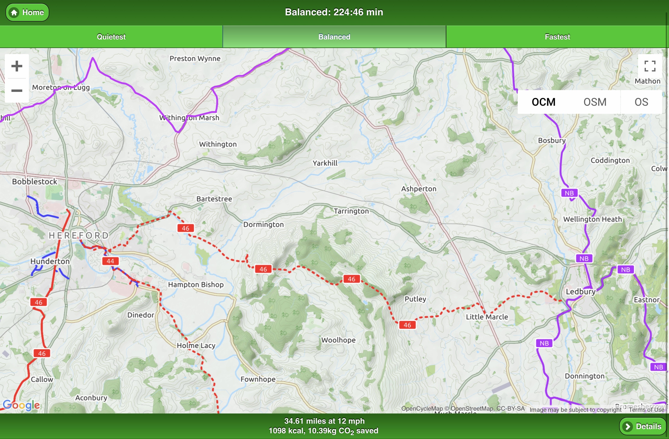
On closer inspection CycleStreets is useful yet only has 3 (broad) route filters (Quiet, Balanced, Fastest)

And damned if I can figure out anyhow anywhere to select the dotted red line route which is a developing section of NCN46

It doesn’t even show up on the NCN/Sustrans maps, just the OCM.

Spent the whole morning trying to figure out how to get that dotted red line into GPX other than minutely cross-referencing and then manually plotting waypoints on another site/app. Feeling a bit stupid, can anyone tell me where to wise up and get it done in a jiffy?

PS, slight aside please support/promote the Herefordshire Gloucester - Canal Trust in their restoration scheme. A cycleable towpath would open up great options for leisure cycling and commuting. It could save lives too. Trust me - cycling by road between Worcs to Hereford is currently a deadly/hilly/madly circuitous pick ‘n mix of a bother. A towpath from Ledbury to Hereford would be incredible and can’t arrive quickly enough.

http://www.h-g-canal.org.uk/html/Map/Map.html


Posted : 28/09/2019 12:46 pm
Posts: 9572
Free Member
Translate
English
Spanish
French
German
Italian
Portuguese
Russian
Chinese
Japanese
Korean
Arabic
Hindi
Dutch
Polish
Turkish
Vietnamese
Thai
Swedish
Danish
Finnish
Norwegian
Czech
Hungarian
Romanian
Greek
Hebrew
Indonesian
Malay
Ukrainian
Bulgarian
Croatian
Slovak
Slovenian
Serbian
Lithuanian
Latvian
Estonian
 

Not quite what you want RE filters, but try the Ride With GPS site - select OS Cycle map layer and 'Optimize For' bikes. Click start and end point and go, or follow the orange or purple bike-recommended routes that show up on the OS Cycle layer. I rode 440kmm between Lake Constance/Switzerland side and N Italy the other week on a 2-click one-hit route plan done this way (a gamble but always interesting results) and the route was great. The combo of layers and route-for on RWGPS seems to work well as long as the odd track or byway is OK for you.


Posted : 28/09/2019 4:07 pm
Posts: 5182
Free Member
Topic starter
Translate
English
Spanish
French
German
Italian
Portuguese
Russian
Chinese
Japanese
Korean
Arabic
Hindi
Dutch
Polish
Turkish
Vietnamese
Thai
Swedish
Danish
Finnish
Norwegian
Czech
Hungarian
Romanian
Greek
Hebrew
Indonesian
Malay
Ukrainian
Bulgarian
Croatian
Slovak
Slovenian
Serbian
Lithuanian
Latvian
Estonian
 

Not quite what you want RE filters

Good point, mainly being able to filter out A and B roads and filter in NCN/Sustrans, tracks etc. Road safety being what it is of late I tend to stick to dedicated paths (yeah right, I think we have one 3/4 mile section in the whole district) back lanes, tracks, byways and Sustrans if at all possible. Would be great to link these up without having to plot manually. CycleStreets is close, but would, be great to cull all A roads and filter in/prioritise features such as NCN/Sustrans


Posted : 28/09/2019 4:37 pm