- This topic has 40 replies, 17 voices, and was last updated 9 years ago by scandal42.
-
Route advice: Garburn, Gatesgarth, Nan Bield
-
yoshimiFull MemberPosted 10 years ago
Planning on doing this in a couple of weeks – anyone have any advice on routes? Bit bothered that by the time we get to Nan Bield we’ll be too knackered to enjoy it. Also how long do you reckon it takes? Any route options welcome.
Thankscrazy-legsFull MemberPosted 10 years agoWe did it for ST a few years ago, it’s in the Trail Guide section:
http://singletrackworld.com/trailguide/uk/north-west/the-south-lake-district/
(the “very hard” route)Timings – reckon on about 7hrs although you can always cut out Garburn and just start by going up the road to Kentmere which will knock off a good 1.5 – 2hrs.
Park at Staveley – it’s free, reasonably secure and there’s bike wash/cafe facilities.
qwertyFree MemberPosted 10 years agoTradition states you must start and finish at Wilfs cafe in Stavely. You can do a cheeky shortcut from top Gatesgarth to top Nan Bield to avoid climbing up Nan Bield but you miss the awesome decent of Gatesgarth to Hawes water. Once you drop down to Hawes water your fully commited to the ascent of Nan Bield. Check the weather reports carefully.
chakapingFree MemberPosted 10 years agonb. Gatesgarth had been “improved” to the point where it wasn’t very enjoyable on my visit early this year. So if you skip Garburn you’ll miss some of the best riding and only really have the nan bield descent as a fun descent.
(unless Gatesgarth has changed since, others here can advise I’m sure)
JonEdwardsFree MemberPosted 10 years agoI did this mid August. Didn’t think it was *that* epicly tough. Although it was a decentish day – maybe 5 hrs? (was on my own). I started from Kentmere as the missus wanted to go walking.
The trail from Kentmere to Long Sleddale is quite “meh”. Seems to have been remade/sanitised to avoid being trashed by the 4×4 gang.
Gatesgarth. Non-technical but SODDING steep climb – there was about 3 hairpins I couldn’t get traction on, so some pushing involved. The descent the far side is twisty rubbly fireroad. Not entirely sure why, but I didn’t really bond with it…
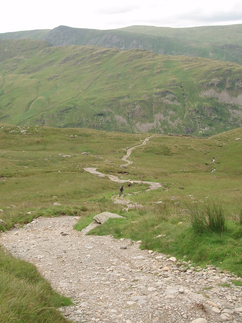
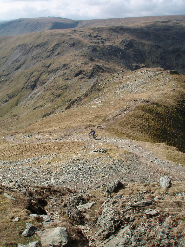
Hike-a-bike up to Nan Bield – bit are rideable, but lots isn’t.
BEAUTIFUL descent into Kentmere. Something of everything. Wish the hairpin section lasted longer. That was lovely.
The trails round the south end of Applethwaite Common are all easy going and the climb up Dobbs road and the west side of Garburn are all reasonably civilised (W side of graburn has been sanitised recently, so would be a dull descent). The descent into Kentmere is bonkers rocky though – hilarious fun.
If I was doing it again, I think I’d do Garburn, then treat Nan Bield as an out-and-back to Haweswater. The north side of NB is sodding technical, but there was only one bit I looked at on the carry up that I had no idea how to ride. It’d be a bloody good day if I managed to ride the rest in a oner though! You could easily spend 3 hrs picking away at sections and linking them into the next bit.
ir_banditoFree MemberPosted 10 years agothe Stavely side of Gatesgarth got seriously washed out in the storms last year. Not been back since, so not sure what its like. The Kentmere side is a bit of a motorway.

P7210028 by ir_bandito, on FlickrCheeky alternative is to go over Harter Fell. Misses the dull descent and the hike-a-bike climb.
P4080078 by ir_bandito, on FlickrIn good conditions, I’d say maybe 6-7 hours.
Also, depending on where you’re driving from, it can be easier to park at Kentmere
loweyFull MemberPosted 10 years agoIf its cheeky your after then personally I would go Harter Fell, Nan beild, but instead of doing the classic hairpins into Kentmere, carry up Mardale Ill Bell, cut over to Thornithwaite beacon and then the ridge to the top of Garburn via Froswick – Ill Bell – Yoke. From Yoke its an absolute hoot all the way back to Kentmere.
Nan beild is ok as a tick off exercise but there is much more fun stuff “if you get, er, lost :lol:”
When you thinking of doing it Danny… I have some free Saturdays coming up ?
Ecky-ThumpFree MemberPosted 10 years agoDanny, I’d agree with the suggestions of Harter Fell rather than down Gatesgarth to Haweswater.
Alternatively…
Rode Lowey’s route in reverse earlier this Summer:
Dubbs to top of Garburn; Yoke; Ill Bell; Froswick; Thornthwaite Beacon; Mardale Ill Bell; Nan Bield, then did the North side of NB to Smallwater (techy, more dabs than the Ribble estuary), then carried back up to do the other side back into Kentmere.loweyFull MemberPosted 10 years agoI’ve rode it that way to Ian, but, with the exception of the pitching down from Mardale Ill Bell I thought it was much better in reverse, although I didnt do the descent to Small Water…
Standing on top of Yoke with the sun going down and setting off knowing that its nearly all balls out down to Kentmere was ace!
tomasoFree MemberPosted 10 years agoGoing up Gatesgarth from Sadgill and then pushing over Harter Fell to Nan Bield and down into Kentmere misses out the dull descent off of Gatesgarth and the painful climb up Nan Bield.
From Kentmere I’d head round to Dubbs and then over Garbun back into Kentmere.
If you base yourself in Kentmere its decent ride, but if you want more then starting in Staveley means you can ride over to Longsledale for Gatesgarth. And from the descent to Kentmere from Garburn head up and over to Green Quarter and over Staveley Fell but dropping down through HP Plantation.
However, a mate quite likes parking at Haweswater and carrying his bike up Nan Bield and then turning round and heading back down. I’d need some brave pills for that descent.
I’ve done the bit over to Ill Bell from Nan Bield and its good fun but you’d want good weather as its a little tricky in places.
D0NKFull MemberPosted 10 years agoYoke to kentmere is a great run, very long one too, but….
I really like nan bield, the switchbacks are fun but further down is good too and I really like the descent to hallow bank quarter. I did NB twice this year once with gatesgarth and once over harter fell, harter fell was better more technical, gatesgarth was boring and the hike up nan bield is awful. If it was me, early start, park in kentmere, over stile end (also resurfaced 🙁 ) up the valley over to NB back into kentmere then high borrans/dubbs/garburn loop, wilfs for a refuel on the way home.yoshimiFull MemberPosted 10 years agoThanks for all the replies guys!
Crazy legs, that’s roughly the one I had in mind originally but as from what others have said I think I’d do the cut over from Harter Fell.
Lowey, doing it on the 5th October if you fancy it (expect a slow pace tho)…looking on the maps, that route from Yoke to Garburn looks like a great (long) downhill, but I’ve never done Nan Bield and it’s one I’ve always wanted to.
I think we have a winner though – DONK – that looks good!
Kentmere – Stile End – Sadgill – Gatesgarth Pass – Harter Fell – Nan Bield Pass – Kentmere – High Borans – Dubbs Reservoir – Garburn Pass – Kentmere
I like the way that it takes in all the things I had in mind but finished with the blast down Garburn to finish:)
How easy is it to park in Kentmere?
tomasoFree MemberPosted 10 years agoGet there early at weekend as it is very limited. Staveley is a better betand what could be better than finishing at a brewery!
Doing Nan Bield next Wednesday night and looking forward to it.
NobeerinthefridgeFree MemberPosted 10 years agoI remember a really nice bit of trail between kentmere and dubbs, IIRC you come out of kentmere (after we’d done garburn) and there was a bridleway on the left, which eventually led across some heathland and a belting rocky, muddy descent back to a road.
Edit – just checked the map, turn off on left is marked as ‘long houses’ and the descent I’m on about looks like it finishes at ullthwaite bridge I reckon. Nice bit of trail and well worth the diversion.
crazy-legsFull MemberPosted 10 years ago…and there was a bridleway on the left, which eventually led across some heathland and a belting rocky, muddy descent back to a road. Does that sound like high borrans?.
No, I think you mean this one.
Staveley Head Fell.High Borrans is on the other side of the valley.
The best route back to Staveley from Kentmere is Sawmill Cottage
Go through the farmyard at Kentmere, climb up Hall Wood, descend to a gate and a small stream. Turn immediate left and follow that track, flat at first, slight climb then a screaming descent through two stream crossings. Brilliant fun.chakapingFree MemberPosted 10 years agoI think I know the track nobeer means, you head from Kentmere on the bridleway at Hall Wood and then turn left down toward Sawmill cottage and the bridge.
Comes out as “three rivers descent” on Strava IIRC, I’m sure the locals can advise better though. Cracking little descent anyway.
grumFree MemberPosted 10 years agoYeah that is a fun one, especially when it’s dry.
Cool thread. 🙂
yoshimiFull MemberPosted 10 years agoI think I’ve done that Sawmill bit last time I did Garburn and enjoyed it. Shame that Dave, maybe next time you’re doing the Yoke-Garburn route I’ll tag along.
The wife is out on a hen-do tonight so I’ll create a gpx tonight…Friday night…how rock’n’roll am I!?
Good idea on the route to take now, the one I said above but prob allow for stat/finish at Wilfs in Stavely rather than get to Kentmere to find parking a nightmare – thanks again all 🙂
loweyFull MemberPosted 10 years agoCant you delay it a week or do it the sat before ?? Just to suit me!! 😀
yoshimiFull MemberPosted 10 years agoIf it was just me Dave I would but already got another 6 people up for it and had the date set for a while, sorry fella 🙁
What do you think of the route though?
tomasoFree MemberPosted 10 years agoThat route looks fine. The hardest part is up on Harter Fell and turning at the cairn for Nan Bield, although last time I did it there was thick snow and folks skiing
loweyFull MemberPosted 10 years agoGood route Danny. You’ll have a blast. Just take a map and compass or a GPS as the top of Harter Fell is a bit flat and bleak and it can be easy getting a bit misplaced if the clag is down.
crazy-legsFull MemberPosted 10 years agoHow easy is it to park in Kentmere?
It isn’t. Don’t do it, it’s a long single lane road to get up there, there’s hardly anywhere to park and it pisses the locals off. Also makes doing Garburn much more difficult.
There’s acres of free parking at Staveley, bike wash, bike shop, cafe, toilets, changing all there. There’s nothing at Kentmere.
Even riding up the road to get there is only 20 minutes but there’s also loads of really good off-road routes to get up there.yoshimiFull MemberPosted 10 years agoAgreed Crazylegs – I believe a few people started not far from Kentmere and did Nan Bield last night (Tomaso?) but there’s still not much room for more than about 3 cars…I think Staveley is the only option – results in quite a bit of road work but the makes the final descent to Sawmill cottage the obvious choice which is good.
Whats the part of the route like from Staveley, up Hall Lane and then over Cocklaw Fell to Sadgil….looks like (on Google Earth) the path over Cocklaw Fell disappears not long after the top of Hall Lane…is it easy to follow?
Ecky-ThumpFree MemberPosted 10 years agoDanny,
When you leave the road, then track, and get onto moorland, the path is fairly distinct and easy enough to follow. You’re aiming straight over Birk Rigg, so it’s just a case of keeping left and keeping to the higher ground. Hopefully Skeggles water will be visible on your right once you’re high enough.postierichFree MemberPosted 10 years agoMet Tomaso on the Sadgill descent started from Staveley the BW cocklawfell is very boggy in places 🙂
http://connect.garmin.com/activity/381353900yoshimiFull MemberPosted 10 years agoPostie – Did you fly from Kendal to Staveley? 😉
How boggy is boggy? Boggy enough to give it a miss and take the road to Stile End and cut across to Sadgil or just MTFU/WTFU boggy patches?
postierichFree MemberPosted 10 years agoIt was dark so we encountered bigger bogs you will be fine 🙂
MugbooFull MemberPosted 10 years agoDid you do the ride yet? If so, was it as good as you hoped? How long did it take?
Cheers Jason
NobeerinthefridgeFree MemberPosted 9 years agoSo, 6 months later! Is the descent down off yoke to garburn worth not doing nan bield down to kentmere for? Thinking of this next midweek.
postierichFree MemberPosted 9 years agoIf you mean ill Bell its brilliant 100% rideable but100% cheeky!
NobeerinthefridgeFree MemberPosted 9 years agoYes, Rich, partly. Was planning Harter fell – mardale/ill bell – thornthwaite crag – froswick – yoke, then down onto Garburn pass.
thekettleFree MemberPosted 9 years agoDon’t bother summiting Thornthwaite crag – take the a cracking singletrack that contours round from Ill Bell towards Froswick. Descent from Yoke to Garburn has a significant number of steps on it now, and has been also been resurfaced (smooth) near the top. Alternatively if you want more Harter-Fell style steepness, summit Thornthwaite and descend West with much excitement to Threshwaite Mouth, then head South. All excellent walks of course.
NobeerinthefridgeFree MemberPosted 9 years agoGeograph.org is a great site for checking out trails, the descent off of Mardale Ill bell, before you even start nan bield, looks sweet.
The topic ‘Route advice: Garburn, Gatesgarth, Nan Bield’ is closed to new replies.