- This topic has 81 replies, 29 voices, and was last updated 9 years ago by richpips.
-
Destroying the Peak District trails, help required
-
mattrgeeFree MemberPosted 10 years ago
The work up on Chinley Churn needs to be queried at tonights meeting as well. I opened a case with them on Monday enquiring who is doing the work and why? Ref is 414462 if that helps?
rob-jacksonFree MemberPosted 10 years agoI urge you all to join the facebook group/twitter of our Advocay Group peakdistrictmtb.org. The more we can pool ideas, experiences, skills and knowledge the better for all of us.
Our Aims: Peak District MTB is an advocacy group aimed at using the collective voice of the Peak District’s resident mountain bike community and seeks to improve, preserve and promote access interests for mountain bikers who live and ride within the Peak District National Park. We would also love to have the support of riders from outside the Park and you can offer this through joining us as a supporter member.
thisisnotaspoonFree MemberPosted 10 years agoWhy am I having to argue that poorly thought-out work by a charity dedicated in part at least to conserving the character of the landscape, which also drastically changes a popular mountain bike route is misguided?
It’s called pragmatism. They could leave the track in a bumpy rutted state which made it a challenge for MTB’ers who used it once in a while and likely aren’t NT members, to get up. Or they could make life easier for the people who work on the land and maybe have to use it every day and really don’t want to face a bumpy rutted challenge each time they need to get up there. It’s a working landscape. If it wasn’t it would look very different.
Not saying it’s best for me or us, but in this case it’s different to DCC just sanitising trails.
dan1980Free MemberPosted 10 years agoThe job they’ve had done is half arsed at best, sloppy, and certainly not a permanent solution. They’ve done a quick fix on the cheap, for reasons best known only to themselves, because they didn’t have a consultation on their plans. It isn’t sympathetic to the local environment, and certainly not in keeping with the NT’s supposed reason for being.
This isn’t sanitisation, this is just vandalism. The job that was done on the Royche, was sympathetic, and a demonstration of what’s possible to repair a well used track, and keeping everyone happy.
stilltortoiseFree MemberPosted 10 years agoThe work done on Roych Clough received extra funding because it is a National Trail. Trying to do that level of repair to a typical highways budget is probably too big a challenge.
thisisnotaspoonFree MemberPosted 10 years agoThe job they’ve had done is half arsed at best, sloppy, and certainly not a permanent solution.
Time will tell, the surface on Jaggers clough seems to be lasting well, I’ve not noticed it being repaired for ~10 years.
because they didn’t have a consultation
What would you have said, “more drop offs please”?
isn’t sympathetic
Actualy it’s a fairly standard technique for protecting old paths, burry them under a foot of something else to protect them from damage from modern trafic.
not in keeping with the NT’s supposed reason for being.
Forever, for everyone? MTB’ers =/= everyone
richpipsFree MemberPosted 10 years agoThis was Edale Rd in September on the section that has recently been refurbed.
This particular section has suffered quite badly with water erosion this year.
 paulrogers6Full MemberPosted 10 years ago
Hi Guys
Couldn’t see any reference to this:
http://singletrackworld.com/2014/02/peak-district-rider-survey/
Apologies if it’s redundant.
P
dan1980Free MemberPosted 10 years agoThe track down into Jaggers clough from the south has a drainage channel and steps to help divert the water from it, and on the way up towards hope cross, the ground isn’t particularly peaty, and clears water very quickly after rain. The same cannot be said for the peaty soil around broad clough. I’ve not been up myself yet, but the discussions I’ve had with folk that have, suggest that any drainage channels that are on the “repaired” section are minimal at best. If the water flow down the track was sufficient to erode and dislodge the bedrock, and the larger bits of loose rock in the trail, it’ll make fairly light work of some 2cm stones…
because they didn’t have a consultation What would you have said, “more drop offs please”?
No, I’d have asked that they consider a sypathetic repair to the trail, and make it usable for all users, including mountain bikers, horse riders, walkers and runners. All that loose crud is frankly dangerous.
isn’t sympathetic
Actualy it’s a fairly standard technique for protecting old paths, burry them under a foot of something else to protect them from damage from modern trafic.http://www.snh.org.uk/uplandpathwork/3.1.shtml
Filling in a trench with aggregate does not help blend it in with the local surroundings. The trench before, whilst not in great nick, at least looked like it belonged there…
not in keeping with the NT’s supposed reason for being.
Forever, for everyone? MTB’ers =/= everyoneThe NT’s general perpous is:
The National Trust shall be established for the purposes of
promoting the permanent preservation for the benefit of the nation of
lands and tenements (including buildings) of beauty or historic interest and as regards lands for the preservation of their natural aspect features and animal and plant life.Preserving a track in it’s “natural aspect” goes along with the idea of a sympathetic restoration, not filling it in with 2 cm gravel.
FOGFull MemberPosted 10 years agoI have just come back from a ride which included the drop from Eyam through Stoney Middleton which I think is the subject of a wheel swallowing rut photo earlier in this thread. Well the news is , somebody was listening! There was a guy working there with a mini digger dumping and leveling yet more tons of gravel/aggregate.
If anybody can remember this used to be a wet, rocky and slippy descent before it was sanitized the first time. Although it could be tricky it never produced the ruts caused by a casual skim and tons of gravel.
Once they start the sanitizing process the Council or National Trust have to keep going because the new surfaces can wear much quicker than the original natural surface especially if rock.richpipsFree MemberPosted 10 years agoI went up Edale Rd as far as Stony Ford.
Can’t really see what the fuss is about. The bottom section that for years had limestone ball bearings is much better.
The (current) works goes as far as the turn off to Kinder Low, above that, so far it’s the same as before.
Pictures go from the bottom gate as far as the gnarly bit below the ford.
Note the alt. (created) path above the improved sections. There is lots more of this stuff above the ford. In fact the fence on the lower section was built some years back as the field was ridden in preference to the track.
There are obviously lots of riders on Edale Rd and elsewhere who don’t have the awesumz skillz of the average STW rider.
http://www.flickr.com/photos/richseipp/sets/72157641870178353
mattrgeeFree MemberPosted 10 years agoTop job getting the pictures Rich. The material they’ve put down is far bigger than I expected, I was expecting scalpings or similar but that looks pretty substantial. Any evidence of them continuing further up?
I’m off to check your Strava times to make sure you haven’t claimed an Edale road KOM!
In all seriousness, the ruts were in desperate need of repair and that repair work isn’t nearly as bad as I expected. I was hoping to get up to Chinley Churn tonight to see what the situation is up there, but didn’t get chance. Any once else been up?
richpipsFree MemberPosted 10 years agoThere looks to be a few inches only of cover, there is a transition picture.
I’ll pop up Chinley Churn tomorrow.
I got a few PRs tonight even though I was stopping for pictures. 😈
SquirrelFull MemberPosted 10 years agoI have to say this seems a bit odd to me. In my experience the NT go to great lengths to do repairs to paths, drystone walls etc in a sympathetic and sustainable way. Might it be temporary or some other agency?
BadlyWiredDogFull MemberPosted 10 years agoI’m going to pop back and take another look at this when I get the chance. I wonder if maybe the sudden change from the existing surface to the new one when you’re heading towards Hayfield makes it feel worse than it is.
And at the back of my mind is the question of, if the NT can do this low down on the that track, what’s to stop it happening to the entire length of the trail from the top of the Jacob’s climb.
rob-jacksonFree MemberPosted 10 years agoThe track needed work on the length that has been covered if we are all honest. The surface was really broken up and undermined in patches.
christhetallFree MemberPosted 10 years agoThis was Edale Rd in September on the section that has recently been refurbed
Richpips – I’m presuming Coldwell Clough and Edale Road are one and the same, so just wondering how far up the track that pic was taken. When I rode up it in Jan 2013 I’m pretty sure the all the stuff that has been worked on was rideable, so for something that dramatic to appear in 8 months of relatively dry weather (ah, remember that!) is testament to the fact that work was needed.
And as you point out, limestone has been replaced (or covered) with gritstone, which is to be applauded
mattrgeeFree MemberPosted 10 years agoso just wondering how far up the track that pic was taken.
Looking at the pictures I’m almost certain the repair finishes here:
http://www.streetmap.co.uk/map.srf?X=406648&Y=386092&A=Y&Z=115
christhetallFree MemberPosted 10 years agolooking at the map it would appear that the work finishes at the national park boundary, which may or may not be significant
Not that being inside the national park seemed to concern DCC with their works on Wigley lane or Stanage Causeway
thepodgeFree MemberPosted 10 years agoI’m confused. are we saying that now we’ve seen the repairs on Edale road we’re happy with them or are we still angry?
richpipsFree MemberPosted 10 years agoI see the horse rider avoided the boulders.
The horse did, but you’ll also see a number of tyre marks there.
It’s very rare that I see a horse up there though.
I’m presuming Coldwell Clough and Edale Road are one and the same
Coldwell Clough is at the bottom of the section. If you know where Edale Cross is, the track that joins the two.
Hayfield has had some very heavy rain events in 2013. We had nearly two inches of rain in under an hour on one day, which caused lots of localised flooding and damaged a number of trails in part. I can think of a few sections that had similar big holes as the one my bike is pictured in above.
I’m confused. are we saying that now we’ve seen the repairs on Edale road we’re happy with them or are we still angry?
Seems like they’ve done a good job to me. Once there’s been some traffic and weather it’ll be OK.
thepodgeFree MemberPosted 10 years agoIn that case are we all tweeting DCC with the good news or do we only tweet bad news?
Its hard work being outraged
rogerthecatFree MemberPosted 10 years ago@Podge – at some point we’ll level out at mildly ambivalent.
richpipsFree MemberPosted 10 years agoIts hard work being outraged
Looks like some outrage may be in order.
I went up Phoside earlier and took some piccies.
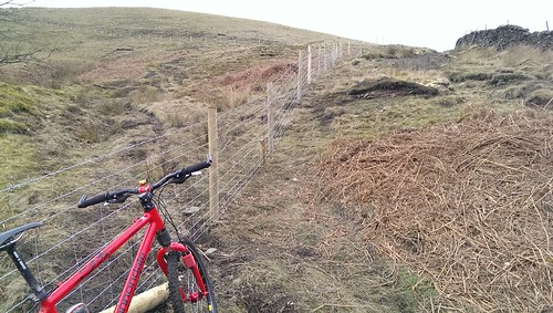
I spoke to someone up there (not the tenant, or landowner) and they have fenced off a large section of Foxholes Clough to plant 6000 broad leaf trees.
There used to be a path that I always used as a descent (which is marked on the map SK 034 857) this is now inaccesible. Instead you have to continue to SK 034 858 before turning right.
From the bottom.
From the top.
I also went up to the track to New Allotments. They are rebuilding the wall, and appear to be chucking the junk into holes in the path. No one to talk to up there though.
Other pics here -> http://www.flickr.com/photos/richseipp/sets/72157641908288783/
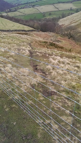
ivorlottFree MemberPosted 10 years agoIs that actually a BW though or footpath?
Admittedly everything else around there is BW, but putting those GR’s on the map, looks like that one section is a footpath to me?thepodgeFree MemberPosted 10 years agoCrap, I just told the navy they have extended shore leave, they’ll not be happy about this.
Is the one in the pic above an actual bridalway? It must be the least used one in the world
richpipsFree MemberPosted 10 years agoHmm, on the 1:50 it looked like a BW, on the 1:25 it’s a FP.
Either way it’s a blocked ROW.
GavinBFull MemberPosted 10 years agoYup, that looks like a FP, but still a ROW. Where the get-out will be is that it is ‘only’ 100m of FP with a BW running alongside the fence, so I hear the response now, saying that a viable alternative is available.
slowoldmanFull MemberPosted 10 years agoI took a walk down off Kinder via Edale cross today. The resurfacing doesn’t look bad (one of my big gripes with DCC is their use of road planings on nice limestone terrain).
How it will age is the question. It might bed down nicely or get washed out into runnels depending on the weather. Anyway, it’s pretty horrible at the moment to walk on and I would imagine not much fun on horseback. A bike is probably the best option.
slowoldmanFull MemberPosted 10 years agoHmm, on the 1:50 it looked like a BW, on the 1:25 it’s a FP.
Either way it’s a blocked ROW..My 1:25000 (OL1) has it as BW. There is a very short FP branching right off it further down nearer the wall.
DCC’s online mapping shows it as a BW.thepodgeFree MemberPosted 10 years agoWhile they should have put a note up about closing a RoW and yes it looks like a fun bit but is the alternative much more hassle?
richpipsFree MemberPosted 10 years agoHaving ridden Edale road with some intent to get up there quickly today, I can say it rides OK from the bottom.
Loads better than it was before. Traction is still marginal though. It should settle nicely.
The top section above Stony Ford is still wild west though.
I did see a couple of NT landies up near the top. No sign of them doing further work though.
horaFree MemberPosted 10 years agoI rode Roych Clough last weekend. Its actually ok. I was expecting a Chapel Gate surface
FOGFull MemberPosted 10 years agoA mate was telling me that the rubble chute drop from Rebellion Knoll to Brough has had the classic motorway treatment. Not seen it myself and it might be old news but the sanitisation program seems to be gathering pace.

The topic ‘Destroying the Peak District trails, help required’ is closed to new replies.