- This topic has 28 replies, 6 voices, and was last updated 10 years ago by DanW.
-
Warminster/ Westbury/ Mere locals… some route help please?
-
DanWFree MemberPosted 10 years ago
Hi all,
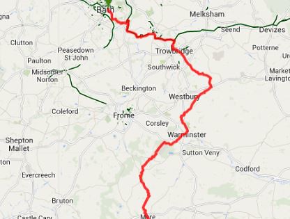
I plan to ride from the Bath direction to Mere and have planned out a route.

I was just wondering if the locals could help with:
– More off road?
– More interesting off road?
– Are the off road bit I’ve planned passable even in very wet weather? (probably the most important point as a long trip could quickly get very miserable if clagged up!)
– Quieter roads where roads are avoidable?The plan is:
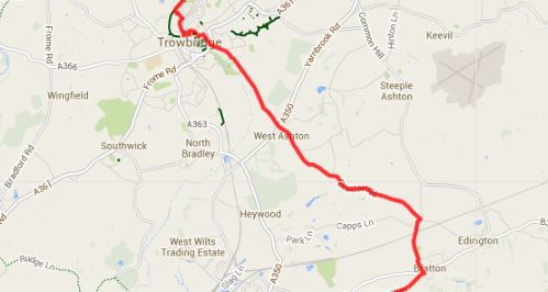
Bath -> Trowbridge (along the Two Tunnelsbike / canal bike path)
Trowbridge -> West Ashton -> Bratton (along the lanes- the only substantial bit on the road I think)Up Port Way (Lane) -> By-Way the Bridleway (Imber range path) then Bridleway to Upton Scudamore (Mid Wilts Way)
Then lanes in to Warminster -> Bridleway (Cannimore Road) towards the Holiday Village
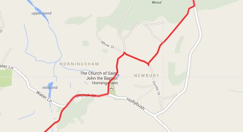
Lanes to Newbury Wood past the holiday village
Short bridelway by Newbury -> lane then By-Way to Round Hill Farm
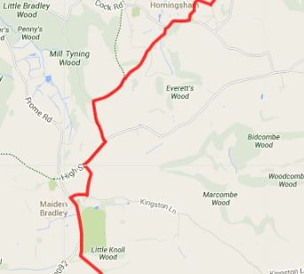
Lanes in to Maiden Bradley -> short horrible road (B3092)
Bridleway past Rodmean Farm and continue along the bridleway to Manor Farm by Mere
Anything I could improve to make a more efficient or enjoyable Winter route? I feel I’m missing a lot of interesting stuff around Longleat. Main question is, is there anything there that gets very clagged up and should be avoided in the middle of Winter?
Thanks in advance!
slowoldgitFree MemberPosted 10 years agoYour route Trowb – W Ashton is a narrow road and very busy, esp in rush hour. Not much alternative though. If you use the back lane to the E of M Brad you’ll miss the worst of the 3092, narrow, bad visibility, parking.
Sorry, I’m out of date on rideability.
slowoldgitFree MemberPosted 10 years agoAnd Cannimore bridleway is normally ok, hard surface and that. There’s a short length of cycle route 841439 to 834433 that is a pleasure to ride.
DanWFree MemberPosted 10 years agoThanks slowoldgit, that is exactly the type of advice I was hoping for. Identifying smaller roads and checking them out on streetview is one thing but can’t really tell you if it is a locals main route somehwere.
Your route Trowb – W Ashton is a narrow road and very busy, esp in rush hour. Not much alternative though.
Do think it’s worth doing these extra Bridelway sections to avoid that lane?
If you use the back lane to the E of M Brad you’ll miss the worst of the 3092, narrow, bad visibility, parking.
Maybe something like this? It looks like a bit of a slog across a field though… maybe going in to Kingston Devril then across the bridleway by the gliding club to join my original route is better?
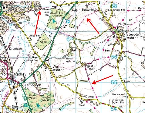
cinnamon_girlFull MemberPosted 10 years agoI would say that it’s nicer to go through Steeple Ashton where there is a fantastic looking church.
Also, in some ways you’re missing out on the views from the ridge. If you could pick up the ridge eastwards somewhere as it’s really scenic.
If you’re able to it would be worth checking out to see if Imber Church is open when you’re doing this mammoth ride. There’s a very interesting display there with copies of War Office documents and photos. If that floats your boat obviously!
Do keep us posted on this. 🙂
Edit: just seen your map and I’ve actually seen one of those back roads totally iced over where there was a slight descent, gave me a fright I can tell you! Often covered in mud and a few potholes too.
slowoldgitFree MemberPosted 10 years agoAs c_g says. The MoD opens up routes to Imber Church sometime over Christmas & New Year. So a route south-ish from Bratton, turn W at spot height 136 might be an option. Hard surface army tracks but with pot-holes.
Can’t comment on Trowbridge area.
(edit) I wouldn’t chose your M Brad dog-leg, just ‘Back Lane’ southish from 804392
DanWFree MemberPosted 10 years agoThanks cinnamon girl for the extra help and advice!
Also, in some ways you’re missing out on the views from the ridge. If you could pick up the ridge eastwards somewhere as it’s really scenic.
Do you mean pick up By-Way a bit further East around the Bratton area? I am all up for taking in interesting views and trails if it worth it 😀 The ride is already around 45 miles so I have to be a bit careful of adding lots more length or climbing
If you’re able to it would be worth checking out to see if Imber Church is open when you’re doing this mammoth ride. There’s a very interesting display there with copies of War Office documents and photos. If that floats your boat obviously!
Great suggestion!
Edit: just seen your map and I’ve actually seen one of those back roads totally iced over where there was a slight descent, gave me a fright I can tell you! Often covered in mud and a few potholes too.
Which lanes roughly?
Thanks again!
DanWFree MemberPosted 10 years agoThere’s a short length of cycle route 841439 to 834433 that is a pleasure to ride.
The short bit through Bucklers Wood?
There also looks to be a track pretty much opposite this heading in the Crockerton direction not marked on the OS map- is this worth a trip too?
nickseeFree MemberPosted 10 years agoDan, see picture below. some nice singletrack just of the cannimore bridal way. Turn right of the bridalway up a track towards tascroft farm (shown on OS map). sharp left at top of short climb and follow singletrack adjacent fields towards ‘nutball’ (the twisty bit near a362 roundabout) you should exit near end of cannimore bridalway.
follow cyclepath towards nockatt coppice, enter the woods opposite carpark, turn left and follow any path to lead you down towards white street.
cinnamon_girlFull MemberPosted 10 years agoOpening times for Imber Church, I can highly recommend the Salisbury Plain honey that they will probably be selling there:
http://www.imberchurch.org.uk/
Yes, completely understand about diversions but if you’re able to, say, join the ridge at Erlestoke then you’ll enjoy far-reaching views as well as the curves of the hills.
As regards the potentially dodgy road then it would be the one at the bottom of the bridleway that leads to East Town. Not all the water runs off very well on these little roads. I think it was January.
You do promise a full write-up don’t you??!!
slowoldgitFree MemberPosted 10 years agoThe short length of cycle track goes just outside the C Parks fence along the un-numbered road that goes SW, not Bucklers Wood. From 846430 to 854420 is a hard-surface track, takes you down through woods and beside the lake. They don’t seem to mind you riding from 848420 to join bway at 854412. But I’ve not ridden this lately.
Note previous posts about Longleat and cycle routes.
captain_bastardFree MemberPosted 10 years agoWhere to start! Some good advise already given, I know most (if not all) of the whole area your looking at so can pretty much give you a track by track guide
Depends how much you have in the legs, loads of great singletrack between bath and Trowbridge, but easier to warm up as you suggested, then not great which ever way, but steeple Ashton is probably best.
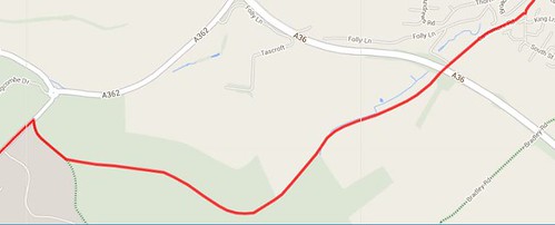
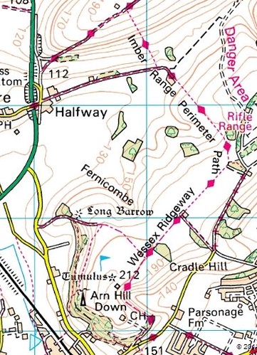
The imber range tracks are fire roads so quick, to link up with Warminster I’d drop off down Arn Hill (choice of singletrack down), then cannimore longleate (lots and lots of singletrack options, but you’d need a guide to join up).
You can join Longleat almost entirely off road to Mere via Gare Hill / Alfred’s tower (too much detail for here, but fairly simple to follow)
you can stretch things out by going over the devrils instead of Alfred’s tower, and dropping straight down into Mere, either straight up to cold kitchen hill from Longleat forest, or make it a longer route by staying longer on the imbed path, dropping off at knook and crossing the wyle valley at uptown Lovell over to great ridge woods, then over to the deverils
Like I say, where to start! If you email me I can provide much more detail
DanWFree MemberPosted 10 years agoYou do promise a full write-up don’t you??!!
I wasn’t going to but after so much helpful advice (and the bike pretty much built up from STW) it would be a shame not to! 😀
DanWFree MemberPosted 10 years agoThanks Captain Bastard
Depends how much you have in the legs, loads of great singletrack between bath and Trowbridge, but easier to warm up as you suggested, then not great which ever way, but steeple Ashton is probably best.
The Bath is the bit I know best and I could pick a dozen decent off road routes towards either Frome or Trowbridge. Given the ride will be on the limit of my legs (and I’m currently doing 18 hour work days) I think it is better to make use of the canal path to Trowbridge and have a bit more fun on the unfamiliar parts from Trowbridge onwards.
I did consider the bike path/ route to Radstock then Frome but it would miss out the Ridgeway around Westbury. The downside to taking in the Ridgeway is the road link between Trowbridge and Bratton area but as you say I can’t see a way around this (and my legs might thank me for the road!)
Modifying the route to take in Steeple Ashton seems like a good bet by the sounds of it 😀
The imber range tracks are fire roads so quick, to link up with Warminster I’d drop off down Arn Hill (choice of singletrack down)
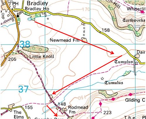
Good to know the track should be hard and fast 😀 Are the footpath sections of the Perimeter Path rideable (if a little cheeky)? I.e. between Upton Cow Down and Field Barn and between Field Barn to the Arn Hill area? Where would you recommend on the section below?
You can join Longleat almost entirely off road to Mere via Gare Hill / Alfred’s tower (too much detail for here, but fairly simple to follow)
I did consider following the treeline through through Alfreds tower and Stourhead but there aren’t many rights of way for a bike and some of the tracks always used to be pretty boggy (this was a few years back mind when I was a yoof building jumps and drops in the Tucking Mill Hanging area of the woods 😀 )
longer route by staying longer on the imbed path, dropping off at knook and crossing the wyle valley at uptown Lovell over to great ridge woods, then over to the deverils
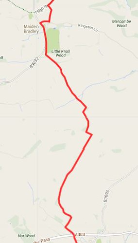
I don’t have the legs for this but do fancy exploring Wite Sheet Downs in to Mere if the route I suggested here looks rideable?
Thanks again all!
DanWFree MemberPosted 10 years agoThanks Dan, it’s appreciated. 😀
I normally wouldn’t stop on a ride and keep going at all times instead, but with this longer ride I might just need an excuse to stop for the odd photo 😉 Even if the ground it hard and I blast around it will be 4 hours minimum I reckon, most likely nearer to 5 hours with the navigation and odd wrong turn
DanWFree MemberPosted 10 years agoActually, another point to add:
If I decide to do this in the opposite direction does any of the above advice so far change? Any new descents I could take in?
hh45Free MemberPosted 10 years agoCaptain Bastard is the man to listen to I think. I only know the southern half of the route but would tend towards Cold Kitchen Hill / Great Ridge Wood and the Gliding Club option. I would say that the Downs are fairly OK at this time of year if it hasn’t rained hard for say 4-5 days. Conditions do change quite quickly and 10mm of rain or 2 dry days can make a real difference here.
From the German Village on Salisbury Plain (GR 015455 OS 184, 1:50,000)to Mere is fairly well established ride of mine but a slog in winter. From there I would head west to Chitterne, Upton Lovell, Great Ridge Wood, Monkton Deverill, Kingston D, gliding club, Mere.
DanWFree MemberPosted 10 years agoHi hh45, I don’t suppose you would have a .gpx file of the route you mention you could email across?
I have modified the route to take in the suggestions of everyone so it now sites at 44 miles/ 71km. More than far enough for my legs!
Changes:
– Going to ride the route from the opposite direction so I have the legs for the new trails and bigger hills then have mostly flat canal paths in to Bath when my legs will be dead. It also leave me the option to either head in to Bath quickly or play around Bath Uni trails or similar if I have anything left!
– From Mere I now plan to go to Kingston Devrill following the bridleway via the gliding club
– From Kingston Devrill I’ll climb the By-Way on Cold Kitchen Hill, then drop back down in the Newbury direction along the bridleway keeping Woodcombe Wood and Bidcombe Wood on the right hand side.
– Lanes to Shearwater
– Going to try and take unmarked forest tracks from Shearwater to sit just North of Crockerton to Bucklers Wood as before
– At Westbury I plan to stay on the Imber Rangers Path a bit longer and drop down the bridleway heading North in to Bratton that passes just to the left of Longcoombe Bottom.Should be quite an explore and bloody tiring given the tiny amount of riding I have been doing lately!
slowoldgitFree MemberPosted 10 years agoISTR Brimsdown – Cold Kitchen Hill has the parallel bridleway and rupp along the ridge. Something to do with the boundary between two estates perhaps – Lords Bath & Som? They don’t actually meet but there is a gate in the fence between. Or was. Which would let you drop down towards the Deverills. Has anyone been that way lately?
Near the top of the climb up Brimsdown you come out from the wood into a field and if the route vanishes, follow the field edge on your right, curve left, and you’ll find the b’way again
DanWFree MemberPosted 10 years agoThanks again slowoldgit. I noticed the parallel Bridleway/ By-Way and plan to go from one to the other and just thought at the very worst I’f hop a fence somewhere. If there is a gate that is even easier 😀
Main questions now are:
– Is riding from Shearwater to just North of Crockerton in the Bucklers Wood direction going to be ok or are they very anti bike around the lake?
– At Westbury is the descent I suggested in the post above from the IRP path in to Bratton the best way down or is there a better descent to do?Thanks again!
nickseeFree MemberPosted 10 years agoBikes around shearwater lake is fine. Will be busy with walkers if a sunny weekend. i start alot of my rides from the shearwater lake carpark and have never had a problem over the years.just look out for plenty of dogs off their leads!
DanWFree MemberPosted 10 years agoThanks nicksee. No idea when I’ll get this ride done but hopefully before New Year so I can have something to beat in terms of ride length for 2014 😀 A sunny day with fast trails, away from rush hour traffic (cars and walkers) would be ideal… don’t see that happening over the Chritmas/ New Year holidays 😕
slowoldgitFree MemberPosted 10 years agoISTR only the one gate – don’t miss it. Sometime next week I’ll be able check a few details if you still have questions.
slowoldgitFree MemberPosted 10 years agoThe route from Shearwater going NW towards Redway Gate / Bucklers Plantation is the obvious one on the ground, as you leave the lake.
hh45Free MemberPosted 10 years agoHi hh45, I don’t suppose you would have a .gpx file of the route you mention you could email across?
Nothing so fancy I’m afraid but FWIW the new route you propose should be fine. A winter mile fest rather than singletrack rock fest but OK I’m sure.
the top of Brimsdown (dont go Cold Kitchen to the east, a bare, ploughed hill with a beacon), climb the south side from Kingston D, up a decent grass track heading NW then at the top cut right, cross a fence, enter the woods and head due north through nice woodland down to the road and continue north to Horningsham.
DanWFree MemberPosted 10 years agothe top of Brimsdown (dont go Cold Kitchen to the east, a bare, ploughed hill with a beacon), climb the south side from Kingston D, up a decent grass track heading NW then at the top cut right, cross a fence, enter the woods and head due north through nice woodland down to the road and continue north to Horningsham.
I think that is the route I ended up with (or very, very similar) so all should be well. Thank you for the local help!
the new route you propose should be fine. A winter mile fest rather than singletrack rock fest but OK I’m sure.
My main worry was to not slog up a boggy field with a 20% gradient or anything stupid like that but I think I’ve got a reasonable route now with the help of STW 😀
My plan for this ride is to link up visiting family over the holiday period and get a feel for the new areas I’ve never ridden before with a view to making a slightly longer and as tech as possible route in the Summer.
Out of interest, where would you look for technical riding or nice singletrack in the Mere/ Warminster/ Westbury area? Longleat is a good bet I’m sure but anywhere else to hunt out in Summer? I know a lot to add around Bath or Bath to Frome but not anything from Frome/ Trowbridge down
slowoldgitFree MemberPosted 10 years agoOut of interest, where would you look for technical riding or nice singletrack in the Mere/ Warminster/ Westbury area?
For that I think you need to contact the black canon collective and the SPAM people, salisbury plain area mountainbiking.
DanWFree MemberPosted 10 years agoThanks again. MB Swindon also seem to ride around some of the areas I’ll pass through so I’ll give their suggested routes a look


The topic ‘Warminster/ Westbury/ Mere locals… some route help please?’ is closed to new replies.