- This topic has 24 replies, 14 voices, and was last updated 9 years ago by dunmail.
-
Torridon
-
dunmailFree MemberPosted 9 years ago
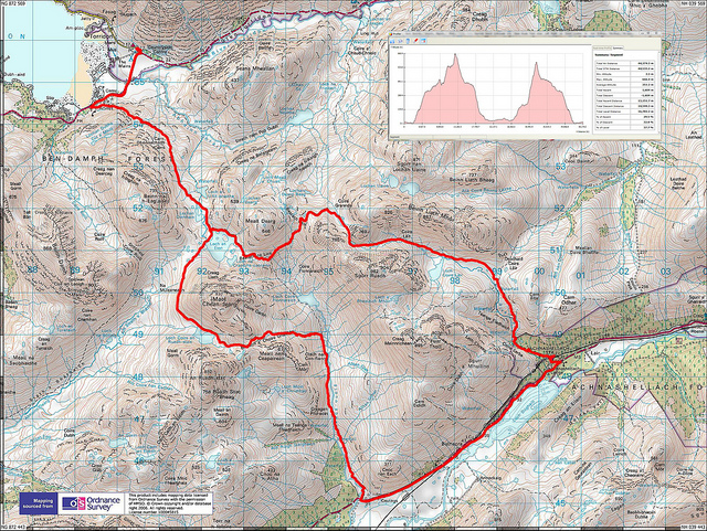
Having done very little in Scotland I’d like the collective’s view on the best way (or possibly ways) to ride the Torridon loop. From the various comics it seems that there are several possibilities:
1. From Coulags up the coire then NE and descend via Coire Lair
2. From Coulags up the coire then over to Annat and return via Coulin Lodge then Coire Lair
3. From Torridon up from Coulin Lodge then up the upper part of Coire Lair then traverse to Bealach nan Lice and the Annat descent.Good, better, best or do all of them? Is Torridon a better starting point for the first two than Coulags?
Also vol 2 of Scottish Wild Trails has the loop around Beinn Damh. How does that compare, is it worth doing?
BoardinBobFull MemberPosted 9 years agoLollipop loop is best.
Push up Annat Descent
Push up to Coire Grannda
Descend Coire Lair to Achnashellach
Along the road to Coulags
Push up to Bealach Na Lice
Descend AnnatbigjimFull MemberPosted 9 years agoThe lollipop is a good day out. You can ride most of the climbs but a good bit of carrying/pushing required.
dunmailFree MemberPosted 9 years agoErr, how much “push up” is there on each of those? Are we talking a couple of hundred metres at a push (sic) or something more substantial?
Also on the map there’s a track marked leading from the Ling hut almost to Coire Grannda – what’s that like, either up or down? Or is there a big missing section to join up with the other tracks?
GolfChickFree MemberPosted 9 years agoHave we got the specific gps etc route for this lollipop loop? Planning on doing it next year after the wedding.
BoardinBobFull MemberPosted 9 years agoFor me, from Coulags to the Bealach Na Lice, I was pushing for an hour and a half. Initial bit was rideable but after about 10 minutes it was too stop start to make riding worthwhile. That was a 4 mile climb of 1,300 feet
KbremboFree MemberPosted 9 years agoAll routes are good! Be prepared as it is a “real” mountain.
The Edit below was last week 🙂 The OP number “1” route.
The no “2” route is the original classic and it is a classic!
Worth stopping at the wee café in torridon for some Coffee+Cake
[video]http://www.youtube.com/watch?v=Kuvj0mTiJvo&feature=player_detailpage[/video]
bigjimFull MemberPosted 9 years agodo you mean a couple of hundred metres vertical or along?! From Bealach na Lice to Bealeach Ban seems to be largely hike a bike from memory, then a little bit more from Grannda over to Lair, and a bit more back up to bealach na lice on the way back too iirc. Its all worth it though.
dunmailFree MemberPosted 9 years agoI was meaning distance rather than height gain. What’s the reason for pushing – loose rock, gradient, drainage ditches every ten metres?
scuttlerFull MemberPosted 9 years agoAlso on the map there’s a track marked leading from the Ling hut almost to Coire Grannda – what’s that like, either up or down? Or is there a big missing section to join up with the other tracks?
I was considering this as an escape on Monday but was unsure of its nature compared to the ‘known’ of the descent to Annat that we’d just come up. I subsequently had a look from the bottom through binoculars and it looks like its in good nick. Google Earth shows the Ling path goes indistinct about 400m from the path into Coire Grannda with nothing visible connecting them so you’d need to be GPSd or spot on with your reckoning to link them straight up with minimal fuss but breaking off as the path bends sharply just after the huge slabs would help. The imaginary line on the ground would follow the line of the bedrock. How good the descent itself is, I don’t know. It’s a similar gradient, width and surface to the others around so will probably be terrific.
YetimanFree MemberPosted 9 years agoWe always park at Achnashellach Station then head down the road to Coulags, up to Bealach na Lice, then down into Annat for lunch. After lunch we ride back up the Annat descent to Bealach na Lice again, hang a left to Coire Grannda / Coire Lair then it’s woop woop woop all the way back down to Achnashellach Station.
bigjimFull MemberPosted 9 years agosteep, rocky and loose – check out the contours. on the way up a lot of the drains are just too wide to clear too.
nick1962Free MemberPosted 9 years agoAlso on the map there’s a track marked leading from the Ling hut almost to Coire Grannda
Almost but not quite! Done this and would do it again especially in dry weather.Most of it is rideable and enjoyable but the path eventually peters out and you need to hike/push a bike for 1-2 km before you meet the trail as it reaches Coire Grannda.
dunmailFree MemberPosted 9 years agoAlmost but not quite! Done this and would do it again especially in dry weather.Most of it is rideable and enjoyable but the path eventually peters out and you need to hike/push a bike for 1-2 km before you meet the trail as it reaches Coire Grannda.
Hmm, seems like a further option might be:
4. Coulags – Bealach nan Lice – Annat descent – road to Ling – track to Coire Grannda – Coire Lair (or Annat/Torridon start point)
loweyFull MemberPosted 9 years ago [url=https://flic.kr/p/ob42Dg]torrid[/url] by lowey.com, on Flickr
Be riding this 2 weeks today. Cant wait.
hairyscaryFull MemberPosted 9 years agoI prefer the classic loop of coulags, lice, Annat, up the road, past the lodges, up to Coire Lair, down Coire Lair to Achnaschelach and back to coulags. (choose any start point)
I found the ‘lollipop’ route concentrated too much on gaining height at any cost.
bloodsexmagikFree MemberPosted 9 years agoHeading up at end of august. Going to have three days riding in that area before heading elsewhere so was thinking of doing a lollipop type route one day and the Beinn Damh loop the next day (a bit shorter so might do something else after or just go to pub). So looking for suggestions for day 3? I’d rather not drive too far away as going elswhere after anyway and I refuse to believe there is only two decent mtb routes in the area!
dunmailFree MemberPosted 9 years agoThere’s a ride on the Applecross peninsular – an out and back to Applecross village, might be in the VB Wild Trails vol 2 book. I think it also appeared in (cough) MBR a few issues ago. Fairly low level on an old stalking path/corpse road.
Edit: Starts at Kenmore on the north coast of the peninsular.
rickmeisterFull MemberPosted 9 years agoThats the one with the two best and longest descents IMHO Lowey….
Also spends more time on trails and less time on the road which misses Corrie Grannda which again IMHO a reall hoot and continuous to Achnaschellach
Think that plot is from me and Househusbands day out… camped at Annat, venison burgers for breakfast and a hot, clear day in great mountain scenery. Well worth the legwork.
dunmailFree MemberPosted 9 years agoJust noticed that trace cuts left just after the bothy on the way up from Coulags. I’ve noticed that track on the maps but it does like like a long hike a bike to the Bealach a Choire Gairbh, I assume that the track on the other side is worth it. That col is about 100 metres higher than the bealach na lice
SwayndoFree MemberPosted 9 years agoI did your number 1 on the way home from a work commitment in Skye yesterday. It was 30.5 C when I left the car at about half 3 and not much less when i arrived back at the car 4 hours later. Make sure you fill your bladder/bottle before you hit the loch in the coire, as there’s not much else after that.
I always do it from the south as it’s much easier for me from home (Evanton). If you do the Annat descent starting in the south you can grab a couple of jars in the Torridon Inn after the memorable descent, then cruise up the glen and head towards the Coulin Pass then cut back into Coire Lair. The descent from upper to lower coire Lair is my favourite for what is my favourite. So much bare grippy rock 🙂
YetimanFree MemberPosted 9 years agoLast year, when we rode it in August, temps were in the mid to high twenties, and it was the same the year before. It was ace. Very hot, but ace. A cold pint with lunch at the Torridon Inn was most welcome.
highlandmanFree MemberPosted 9 years agoDunmail, that alternative climb up to the bealach Coire Gairbh is tougher than Lice and gives a longer route back to Annat. Rides very well indeed and is holding up to trail erosion better than the initial lochside section on the classic descent. When you clear the top of the pass after the white limestone chips section, head straight down into the initial neck of the coire and off what looks like the start of the trail- it isn’t the start and disapears after a short stretch, leaving you on a hillside above the actual trail.
I prefer to approach the classic loop from the Annat side. That way, once you’re in the pub at the end of the ride, you’re in no hurry to leave!
Beinn Damph is an excellent, shorter ride. One climb, one descent that’s about halfway between Annat and lower Lair in technical challenges.
It’s all good….dunmailFree MemberPosted 9 years agoI’m never in a hurry to leave a pub 🙂
Looking at the 1:25K map via Streetmap it looks like the path over the Bealach and the one back to the loch don’t meet – http://www.streetmap.co.uk/map.srf?X=193052&Y=848805&A=Y&Z=115 is that what you are describing? Presumably it’s not too hard to link the two.
The topic ‘Torridon’ is closed to new replies.