- This topic has 47 replies, 18 voices, and was last updated 6 years ago by lowey.
-
Rides in the Lake District near Hawkshead – Suggestions please
-
4roadsFree MemberPosted 7 years ago
Hi I am finallyyyyy going to the Lake district next week staying in Hawkshead and want to try and get some inside knowledge on where to ride off road close by please to Hawkshead.
20 mile loops type stuff – trail centres ?
I will have my car and bike rack for any real beauties but want to stay as close as possible to base.
Thanks
EsmeFree MemberPosted 7 years agoWell, you’re very close to Grizedale, for both trail centre riding, and some excellent natural stuff.
There’s a nice route nearby at Claife Heights. And the BOAT from Knipe Fold links you with the classic Hodge Close and Loughrigg Terrace route.
richardkennerleyFull MemberPosted 7 years agohttp://www.pedalnorth.com/content/lake-district-mtb-routes
Have a look through these, you’ll be right on the edge of grizedale, so there’s all the bridleways in there. The North Face trail isn’t really worth it, apart from a run on the black and incorporating the first few sections of the climb and the final section back from moor top into a longer route of the off piste stuff.
Tour of Coniston for a big day out without using your car.
EsmeFree MemberPosted 7 years agoYes, that Pedalnorth website is very good, also Flat Tyres MTB.
Enjoy your week!martinhutchFull MemberPosted 7 years agoIf you get hold of the Vertebrate Graphics Lakes MTB guide, you’ll find probably half a dozen routes that can be ridden directly from Hawkshead, complete with mapping etc.
Don’t bother with the North Face trail. Apart from the first climb, which is a nice way to gain height, it doesn’t offer much.
4roadsFree MemberPosted 7 years agoCheers all – I’m looking to hopefully finally ride a loop to take me on the top of the mountains to look down on a lake / lakes – like a view I’ve looked at in magazines for years and thought – WOW – one day !!!
sit down on the top and get the flask out for a brew – taking it all in……
rightly or wrongly im taking my only current working bike which is an On One fat bike ….
whitestoneFree MemberPosted 7 years agoThe bridleway out of Grizedale Forest to Parkamoor has grand views http://www.pedalnorth.com/content/p-parkamoor
chakapingFree MemberPosted 7 years agoYou can ride straight out the back of Hawkshead, nice climb to warm you up, and then head over Grizedale way.
You might need to drive somewhere if you want to get on top of a mountain though.
EsmeFree MemberPosted 7 years agoThere aren’t many (any?) bridleways which go to the TOP of the mountains, only footpaths. But don’t worry, there are fabulous views from legal trails, especially Parkamoor and Loughrigg Terrace.
Incidentally, in the Lake District National Park, I always stick to bridleways, BOATs and cycle trails, especially at busy times such as summer weekends and Easter. Why annoy the redsox when there’s no need? Other riders may have different views . . .
ahsatFull MemberPosted 7 years agoThere aren’t many (any?) bridleways which go to the TOP of the mountains
Helvelyn and Skiddaw….
Agree, get the VG guide – loads of different ideas of how to link things up. We regularly stay in Hawkshead as there is some cracking stuff nearby.
NobeerinthefridgeFree MemberPosted 7 years agoWhy annoy the redsox when there’s no need? Other riders may have different views . . .
Tbh the only issues I’ve ever had are on actual bridleways close to the glue pots of Ambleside and grasmere. Generally fat lazy arsed American type tourists that think walking a mile from the car is getting out in the hills, and you on your bike shouldn’t be there.
Spent a fair bit of last weekend on footpaths in the north western fells, not a cross word said, but I always slow down for walkers and disarm with cheery hellos and plenty chat. Vast majority of people are pleased to see you/astounded that you’d take a bike up actual hills.
Common sense should be exercised though, one of my first lakes visits many a year ago saw me trying to descend the path off cat bells on a sunny Saturday afternoon. That’s asking for bother….. 8O.
 whitestoneFree MemberPosted 7 years ago
As nobeer says: get away from the popular walking areas/paths/tops and it’s unlikely that you’ll see anyone or anyone that you do meet will be particularly bothered.
I’ve ridden to the top of Lonscale Fell from the bridleway up Skiddaw, even though the BW was fairly busy (it was early in the morning) there was no-one on Lonscale Fell. I reckon you’d get more hassle hooning down the Skiddaw BW than visiting some of the less popular but cheeky tops.
4roadsFree MemberPosted 7 years agoThanks for the great links.
Is there a place to get GPX files of the routes as I’ll be on my own and wouldnt want to get lost to miss the family lunch meet up times.
whitestoneFree MemberPosted 7 years agoOn the page I linked to there’s a download link at the bottom of the page for that ride (below the map) – all the pedal north rides have them.
If you don’t know the area then a map will be useful as well so you can figure out how to get to your lunch stop. 😉
grumFree MemberPosted 7 years agoIt’s all been said already but if you’ve never been before you’re in for a treat. I’ve ridden all over the Lakes lots and that’s one of my favorite bits definitely. Virtually any BW (or FP 😛 ) round Grizedale/Claife Heights is great.
4roadsFree MemberPosted 7 years agoI will start in grizedale trail centre.
What are the top 3 trails to nail 1st ?
Cheers all. It looks fantastic driving here……
Just got to sort the family and dog 1st ….. gagging to get out and ride …EsmeFree MemberPosted 7 years agoPop into the bike shop at Grizedale. I’m sure they’ll point you in the right direction. Have a lovely day!
NobeerinthefridgeFree MemberPosted 7 years agoI’d go and park at moor top, out through grizedale and down low parkamoor, then head round South of conistin and up to Stephenson ground.
Corking descent to seathwaite, then up n over Walna scar. You wanted views. Lunch/tea in coniston, then head over and pick up Northface trail back to car.
troutFree MemberPosted 7 years agoAn excellent ride we did a couple of weeks ago .

includes the Breasty haw decent , Parkamoor to Nibthwaite
can send GPX if needed but it includes the little detour when we took a wrong track
centralscrutinizerFree MemberPosted 7 years agoThis route is the one that starts in the town and gets you around a lot of good bits.
grumFree MemberPosted 7 years agoHow’s Breasty Haw trout? Bottom bit was fairly trashed by forestry stuff a few months ago.
4roadsFree MemberPosted 7 years agoThanks for those routes.
I got the maiden voyage under my rubber … started at Colthouse plantation across to Belle Grange down to Far Sawrey then up again to Hawkshead.
It surely is rock garden city – very tough but big smiles … shame I got a puncture which I would have put my house on it being a rock pinch flat or slice in tyre from rock but it was a Thorn !!!!! 1st time pumping up a fat tube with a mini pump …. which is no ******* fun at all. I had an emergency mini travel bottle of Jack Daniels which got cracked open as I fixed my puncture next to lake Windermere …. (I’ve had it since last winter when I got punctures in the snow and was freezing so banged one in the camel back when I got back in case I got stuck in the snow again ……. been waiting for the right moment .- ok it wasn’t snowing but it was a Lakes toast ……. 🙂
Shame I hit stinking sheep sh*t bogs which stank up until then it was dry pleasure… not even a fat bike gets through those 2 foot quick sheep sand …..
It got moist and cold quick coming back ..
I met a bloke who said it’s much better the other way from Far Sawrey to Belle Grange and down to Colthouse Plantation. .. I’m sure it would be cracking the other way …
How do I plan a garmin route on pc and get it on my garmin ? Never done this yet ….
I should have bought a house up here ….. mad back garden play grounds ……chakapingFree MemberPosted 7 years agoHow’s Breasty Haw trout? Bottom bit was fairly trashed by forestry stuff a few months ago.
I was there a couple of months ago, new bottom section is riding in now but it’s still heartbreaking.
4roadsFree MemberPosted 7 years agonobeerinthefridge … do you have an image of that route marked up please .. cheers
martinhutchFull MemberPosted 7 years agoI was there a couple of months ago, new bottom section is riding in now but it’s still heartbreaking.
Did it late last month, still worth doing, but the only bit of old bottom section left is the drop down the smooth slabby rock, and even that has changed character somewhat.
littlerobFull MemberPosted 7 years agoIn 2014 I stayed at the YHA in Hawkshead and did some rides from there:
There’s this one https://www.strava.com/activities/169088364 which was the Grizedale North Face trail from Hawkshead (i.e. you start part way round).
Also this one https://www.strava.com/activities/169086717 which appears to share a lot of ground with the image posted earlier by Trout.
A couple of things I would add:
1. Some of the uphills were very hard work (particularly I recall getting out of Hawkshead) because they are rocky and it was wet, so we found that we could get no traction.
2. (In our defence) the links above aren’t very quick, but the lad was only 14 and on a cheaper-end bike 😉HTH
4roadsFree MemberPosted 7 years agoI picked up the Northface trail today from Hawkshead. With these rocky climbs my average speed is snail like ….. I’m taking in the scenery that’s my excuse …….:)
I wanted to go from Hawkshead to low parkamoor but the red trail messed me up I didn’t know what to follow to get there …
Thanks all.
richardkennerleyFull MemberPosted 7 years agoYou got another chance to try again tomorrow? You follow the bridleway out of Hawkshead into the forest and pick up the red trail. Follow that back to the visitor centre. Now pick up the start of the red trail and do the first couple of sections (essentially a big singletrack climb away from the visitor centre.) Eventually, you end up following fire road for quite a while, if you keep your eyes peeled on your left hand side, you’ll see a sign for bridleway heading to Parkamoor, follow that. Once you’ve seen it, you can’t go wrong.
richardkennerleyFull MemberPosted 7 years agoIf you can get your hands on a trail map, you can see where the bridleway heads off.
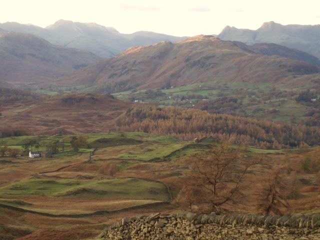
jwtFree MemberPosted 7 years agoNot my images, however that is the view from Parkamoor across Coniston towards the Old Man. Never get tired of the view from Iron Keld / High Arnside, with great descents off both.
4roadsFree MemberPosted 7 years agoRode the Parkamoor Claife heights routes. I was glad once I got off the north face route which wasn’t what I was after – but then when finally into the open – the section where you come out of the forest turn right so you go onto the moorland stretch and see the glorious scenery was a big wow moment … then you see the lake. This was what I was after.
The section down to north nibwaite saw me stack in and smash my garmin … !!!!!! – couldn’t decide quickly enough which line to take …. then it was too late …….. I had just finished the monthly payments on it… gutted.
I can’t time a ride here like I can down south as there all trails are either up or down ….!!!!! So I was in the dog house when I got back hours after I said I would be ….. 🙂
Hoping to do the coniston loop tomorrow . 19 miles but will have to allocate 4 hours I reckon and start at 7am. ….
Thanks again for all the help.
Tomorrow will be my last ride…….
martinhutchFull MemberPosted 7 years agoHoping to do the coniston loop tomorrow
Hope you get on better on Parkamoor/Nibthwaite. 🙂
mcnultycopFull MemberPosted 7 years agoGarmin do some kind of replacement thing if you contact them, I’ve heard…
4roadsFree MemberPosted 7 years agoCheers I will contact garmin.
So is the coniston loop more technical …………….
So how long for this loop for a weekend warrior on a fat bike ?
richardkennerleyFull MemberPosted 7 years agoI wouldn’t say it’s more technical, the Seathwaite descent is pretty rocky, Walna scar is mostly pretty easy going. I’ve done it on a hard tail a couple of times, don’t know what riding a fat bike is like. I imagine the climb up Walna scar could be a drag!! Make sure you take the bridleway through the quarry about half way down Walna scar, turns off to the right. Or if you go all the way, the cheeky path rather than the road back into Coniston. 4-5 hrs is probably about right.


The topic ‘Rides in the Lake District near Hawkshead – Suggestions please’ is closed to new replies.