- This topic has 23 replies, 9 voices, and was last updated 7 years ago by B.A.Nana.
-
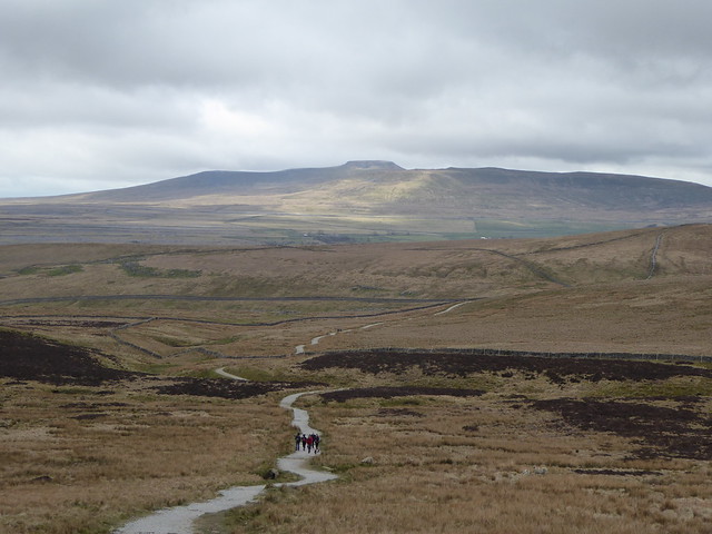
Pen y Ghent descent
-
kirky72Free MemberPosted 7 years ago
My normal ride around those parts takes me up towards pen y Ghent but skirts the perimeter of its base, down to Halton back up via fox up and down into Horton sort of thing. A nice ride but no amazing descents.
The last time I was climbing up from heskith bridge I met a couple of rad your dudes who had ridden out of Clapham with the sole intention of carrying their bikes upto the summit itself which is a proper carry up the steep steps to descend down off the back of.
I can see the line down as it heads down towards Hull pot area. My question is in the absence of any clips on YouTube , is the descent any good and worth that carry up. It could be worked into a loop quite nicely and miss out the Halton, fox up bits which aren’t good when it’s wet.
I know it’s a FP I would be doing it mid week and always show consideration to walkers.
martinhutchFull MemberPosted 7 years agoIt would be a carry pretty much from the stile where the Horton path joins, including a small bit of scrambly stuff to get onto the summit plateau.
The path off the other side is the trade route up, not that steep, only a bit rubbly at the top, afterwards smooth and well surfaced – would just be a bit of a blast. Never ridden it though. Depends how tech you like it, really.
I imagine if you googled it you could get some clips of folk walking up it to give you an idea.
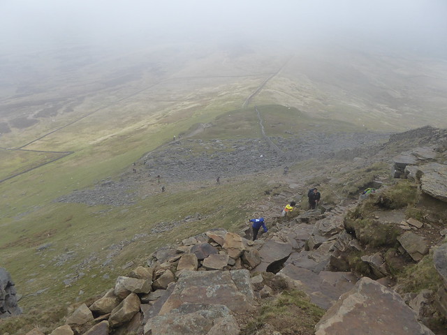
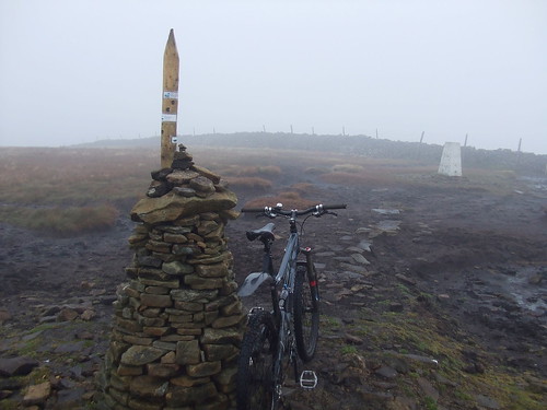
pennineFree MemberPosted 7 years agoWalking down from the summit I saw a guy pushing his bike up from the Hull Pot side. Chatting I said that’s a lot of effort for not much fun other than a quick blast. Apart from a rubbly bit at the top it’s basically a smooth descent to Horton Lane (see photo).

and of course you have to lug it up here
B.A.NanaFree MemberPosted 7 years agoIt’s part of my regular exercise, Horton primary school to the summit in 40.42 is my best effort yet. Anyway, should be good, probably ride up from dale head to the scramble bits, then off the back, a bit techy at first then a smooth run. Water bars are widely spaced so no problem.
kirky72Free MemberPosted 7 years agoCheers guys. Fast rather than particularly interesting, I think I’ll give it a miss.
I take it there’s no other trails of note off the back of the hump, on OS map there looks to be a section of the Pennine way heading off behind and too the right back down to the Tarmac drag up from Halton Gill.
martinhutchFull MemberPosted 7 years agoon OS map there looks to be a section of the Pennine way heading off behind and too the right back down to the Tarmac drag up from Halton Gill.
Over Plover Hill to join the Foxup track? That’s pretty boggy normally, and I vaguely remember the descent being a mixture of rock, bog and tussocks!
The best descent off PyG would be to the south down to Churn Milk Hole, picking up the track to Helwith, but there’s a short scramble near the summit which I’d find tricky to even carry the bike down.
johnx2Free MemberPosted 7 years agoThe descent your talking about is part of the 3 peaks xbike race, and is a 100% ridable fast fun on a cross bike (perhaps bar a three foot peat drop off into a bog that’s caught me out twice now… ) [edit: that was to kirky72]
You can also ride off plover hill at the far end of the ridge, footpath that meets the bridleway that’s part of the usual loop, just fast and grassy after a rocky step at the top. Neither are really worth it on a mtb. Now Ingleborogh, Whernside, Buckden Pike, Wild Boar Fell, Cam Fell are altogether more interesting.
ChrisEFree MemberPosted 7 years agoThis is what it is like riding over there
http://www.everytrail.com/view_trip.php?trip_id=1602501
B.A.Nana – do you live in Horton?
C
B.A.NanaFree MemberPosted 7 years agoB.A.Nana – do you live in Horton?
No lived temp in Gargrave up until July, now in Carleton. Can’t motivate myself anymore for just running locally, but found motivation in jogging/speed marching up a 3 peak or 2, Pen y gent being the most convenient. Usually go twice a week, various routes, sometimes timed and really going for it, sometimes just getting out.
ChrisEFree MemberPosted 7 years agoB.A.Nana – that’s OK I thought you might have been a secret neighbour!
kirky72Free MemberPosted 7 years agoThanks for the help.
As seen as there’s some knowledgable chaps on here so I may as well pump for a bit more info, I’m a bit fed up of riding the same routes.
I came across a clip of a ride around buck den and whilst there’s a bit of comedy riding on there some of the sections look pretty good notably fosse and rakes wood.
Does anybody know if this is a good route, just cobbled together, to try and take in some of those areas.
https://ridewithgps.com/routes/newB.A.NanaFree MemberPosted 7 years agoThat vid first bit is Arncliffe to Starbotton descent which is great and not typical of the area in so much as it’s technical fun. all rideable with one or two 😯 moments. Great because as a regular Dales rider you hardly get any of that type of technical descending.
Didn’t watch anymore of the vid, but we did Buckden Pike again this year and the climb from Starbotton is a typical ok climb, the steep descent off the back of the summit was ok at the top with one 😯 tech bit but a bit rubbish for a long section lower down as they’ve upgraded the path and built big waterbars so close together that you struggle to bunny hop them all unless perhaps you are a really ace rider.
Your ridewithgps link requires sign up so couldn’t view the route.whitestoneFree MemberPosted 7 years agoAs said, Fosse Wood is atypical of the Dales. Most Dales BWs were/are tracks for horse and cart, the ones over Old Cote Moor are closer to singletrack. I’ve only done Fosse Wood once – on a rigid bike with no dropper which probably wasn’t the best bike of choice 🙄 There’s a bit at about 1:26 in the video where you can see some riders stopped that is technical and not advised to fall off. Also that descent is limestone so not good in the wet.
I’ve only done Rakes Wood as a descent once, the other times have been as a climb which is doable without dabs (that was on the YD300 ITT so the bike had bikepacking bags strapped to it). The bit in the video is probably the only tricky bit.
The bit near the end just after they are pushing their bikes through a gap in the wall has now has stone flags for a surface, there’s about 100 metres after that riding by the wall that is technical with some blocky drops then it’s open fast grass down to Litton. That’s this BW – http://streetmap.co.uk/map.srf?X=392489&Y=475099&A=Y&Z=120
Can’t access the ridewithgps link but here’s one I did one evening after work last year:
Arncliffe; BW starting here http://streetmap.co.uk/map.srf?X=393006&Y=472181&A=Y&Z=120 (the first bit of the vid is descending the other side); Moor End http://streetmap.co.uk/map.srf?X=395428&Y=472983&A=Y&Z=120 very rocky loose track down to Kettlewell; BW up Cam Pasture http://streetmap.co.uk/map.srf?X=397170&Y=472505&A=Y&Z=120 to Cam Head http://streetmap.co.uk/map.srf?X=397017&Y=475302&A=Y&Z=120 then down to Starbotton; road to Buckden then BW over Firth Fell http://streetmap.co.uk/map.srf?X=393594&Y=477449&A=Y&Z=120 (some hike a bike on the climb) and down to Litton; back along road to Arncliffe. Only 24Km but over 1000 metres of ascent!I’ve not done the BW leading from Cam Head towards Buckden Pike but have been told it’s a bit boggy.
martinhutchFull MemberPosted 7 years agoYep, Fosse Wood is surprisingly un-Dalesy, tight and slippery most of the year, and that bit that Whitestone mentions is slippy with a big drop off to the right.
Your route link doesn’t work, but most of the BWs in that area are decent.
The climb up from Kettlewell to Cam Pasture is a bastard – has the worst bit of the Fleet Moss road climb as an opener and carries on in the same vein on nasty, rubbly track.
I’ve not done the BW leading from Cam Head towards Buckden Pike but have been told it’s a bit boggy.
It is.
whitestoneFree MemberPosted 7 years agoThe climb up from Kettlewell to Cam Pasture is a bastard – has the worst bit of the Park Rash road climb as an opener and carries on in the same vein on nasty, rubbly track.
Ssshh! 😉
martinhutchFull MemberPosted 7 years agoErr, yes, Park Rash…it’s early. All roadie hell climbs look the same to me anyway!
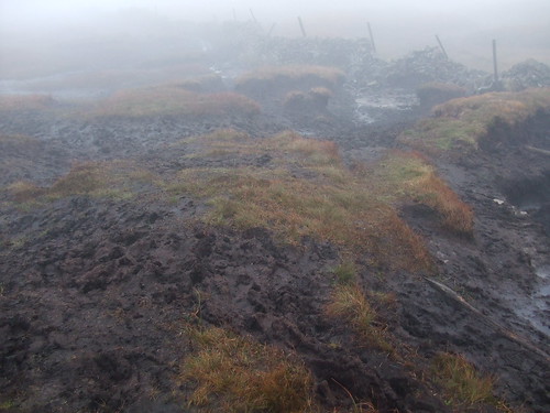
pennineFree MemberPosted 7 years agoDitto what the others have said. Being a regular Dales rider I know which routes to avoid after prolonged rainy spells. That video doesn’t show the long grassy slogs when the ground is wet. I rode direct from Kettlewell to Buckden Pike via Cam/Tor Mere more or less sticking to the wall in the photo in a dry June this year.
Once the bogs are frozen it’s good otherwise expect this
whitestoneFree MemberPosted 7 years agoIt’s worth knowing your rocks in the Dales. Basically there’s Limestone and Gritstone, there’s a few small areas of other rock types but it’s really just those two. Ground overlying limestone drains well but the rock is slippy as hell in the wet. Ground overlying gritstone doesn’t drain well but the rock is grippy unless it’s icy.
Fosse & Rakes Woods are limestone but the tops of the ridges are gritstone, the difference is apparent in the video. The shots by Pennine are of land lying on gritstone.
If you aren’t sure – look at the dry stone walls as they didn’t cart the stone great distances.
Edric64Free MemberPosted 7 years agoYou could always enter the 3 peaks cyclocross when the landowners allow you to ride all the way down as it`s footpath.
jimboboFree MemberPosted 7 years agoI did inglebrough once, started climbing at about 4am, descent by 7 as the sun came up to avoid as many walkers as possible. Was fun to say I’d done it, but was a drag pulling a DH bike up a hill for 3 hours for a 15 min ride. Probably more fun on CX bike as above.
martinhutchFull MemberPosted 7 years agoYou could always enter the 3 peaks cyclocross when the landowners allow you to ride all the way down as it`s footpath.
Don’t they get arsey when you only want to ride one of them on your MTB? I suppose I could get my missus to drive through Austwick at light speed to get into the spirit of the event.
Edric64Free MemberPosted 7 years agoThere is some very poor driving during the event .I don
t see how bad it is in Austwick as im trying not to be last one onto Simon Fell!martinhutchFull MemberPosted 7 years agoim trying not to be last one onto Simon Fell!
That’s another reason I should enter. I’d almost definitely be the last one onto Simon Fell.
B.A.NanaFree MemberPosted 7 years agoRakes wood is the bottom of the decent I described from buckden pike summit, that bit is pleasant enough, just the whole descent has been spoilt a bit now they’ve built in loads of big water bars higher up.
The buckden to Litton BW we do about once a year, bit of a slog when wet, can be very enjoyable when dry or when you’re fit. I find it a love/hate climb depending on fitness/conditions/frame of mind. The descent off the top starts good as said, then turns into typical dales straightforward descent
The topic ‘Pen y Ghent descent’ is closed to new replies.