+1 for the muddy climb. I was chuffed when I managed to get all the way up after two or three attempts. It taught be quite a bit about balance and positioning!
I found the other day its quite fun to ride the other way too, only if no one is coming up obviously 😉
can I 'safely' get to Lee Quarry through Britannia Quarry? It is disused innit?
erm.... the helicopter mite drop the odd stone on you ! 😉
I was thinking more of big cliffs and drops! :-/
I thought Britannia was the working one?
dunno.. according to the OS maps its disused and there are at least two paths running through the middle of it..
Brittania is working and they are activly trying to keep people out. But I have a cunning plan to get two new bridleways round the site. Hopefully getting at least one of these sorted out this winter.
Speaking of new bridleways just put the signage out for a bridleway claim from Goodshaw lane accross to the PBW near Clowbridge. Its a good route and assuming there are no objections should be on the maps soon.
Tony - This would be a great starting point for a PB but I suspect the valley walls are a tad too steep!
[url= http://www.streetmap.co.uk/map.srf?x=387715&y=419675&z=120&sv=387715,419675&st=4&ar=y&mapp=map.srf&searchp=ids.srf&dn=585&ax=387715&ay=419675&lm=0 ]Top of Cowm Res[/url]
It's a beautiful spot
That'd be excellent Tony. Don't suppose there's any plans to do more around Crown Point generally, be an excellent location for some green / blue trails.
ps Tony is there going to be signage on the link track 'lee-cragg' quarry, as i live in Todmorden it best for me to go lee over to cragg (but i hear theres a split path on Rooley moor rd (i havent ever been on this track b4 so im not familiar with it.. 😉
elaine, the split is only about 10 yards from Rooley Moor Road. You can see where both hit the main track. Coming up from Lee just turn right at the top and follow the track (which is the MTL) around the hill keeping left (RM Road carries straight on and down to Stacksteads) and after a short sharp climb you will see the start of Cragg on your right. It is a figure of 8 just be careful where they cross as it is easy to get it wrong. There are some markers on rocks so look for those.
Enjoy
elaine anne - Member
ps Tony is there going to be signage on the link track 'lee-cragg' quarry, as i live in Todmorden it best for me to go lee over to cragg (but i hear theres a split path on Rooley moor rd (i havent ever been on this track b4 so im not familiar with it..
I suggest you make a donation to R&PMRT before you set off, or get a map and compass 😉
Britannia Quarry is not disused - I am the estate manager for it. It is fenced and crossed only by a couple of footpaths that are impossible to follow because of the 60metre cliff (some drop-off!) It is also riddled with old workings which can give way.
We have some brilliant facilities courtesy of TonyL and some great 'other' trails which should make it unnecessary for people to try and ride in active quarries, please keep out for your own safety.
'big n daft' :dont be sooo big n daft ! 😉 just asking thats all as i aint been that direction b4 ...yep i know its not a big mountain or anything to tackle but me n new directions just dont get on !!! 😉
Elaine can I suggest a map and a day on one of our map reading/navigation courses would help you out quite a lot. Signs get removed, moved turned around etc so its always best to know roughly where you are especially when up on the moors surrounded by quarries and old mine workings.
cheers Elspaniel. Was just wanting clarification as the OS maps show the quarries as disused, along with paths across it. I had a look on google earth and it didn't look right!
My initial question was whether I could link up to Lee from Cowm Res, just so that I could avoid the climb up RMR from Rochdale, which I really don't like.
Having said that, I suspect that I wouldn't like being squashed by a big Terex! 😀
Elaine, there's some great tracks from Cowm down to Edenfield and they are fairly obvious too (even in the dark)
[i]It is fenced and crossed only by a couple of footpaths that are impossible to follow because of the 60metre cliff (some drop-off!) It is also riddled with old workings which can give way.[/i]
So the quarry workings have effectively blocked 2 public rights of way.
Can you advise what diversions you have in place? Or is this an issue for the the local ROW officers?
Can you advise what diversions you have in place? Or is this an issue for the the local ROW officers?
TonyL is one of the local ROW officers, IIRC he is working with Britannia Quarry to deliver a good local solution with access for mountain bikers
the same ROW issue exists in Lee Quarry to a lesser extent, do you want him to fill it in?
It is an issue for the local PROW officers and we are working with the quarry to resolve it. Over all the parent company has been very helpful and has assisted with Lee Quarry and the linking route over the moors (most of the new linking route is on their land) so we have a pretty good working relationship.
Rooley Moor - you probably can get to Cowm but it'll be on FP's/informal tracks with some pushing as well. There is an old tramway heading that way from where TonyL's new link comes (almost) into Lee and it's not actually far to go on the ground.
Here are a couple of pics of the link in its current state from the Rooley Moor side. Looking good!
This one's the Crag Quarry fork:
[IMG] 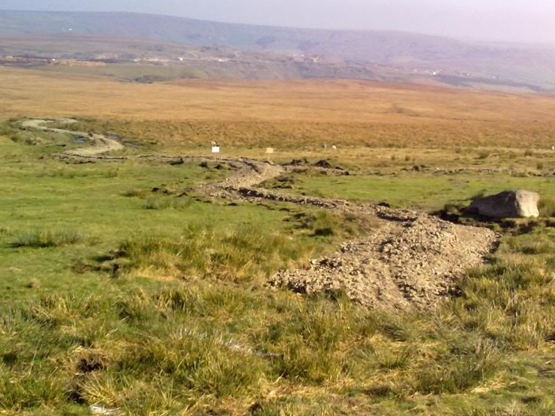 [/IMG]
This is from the Rochdale side:
[IMG] 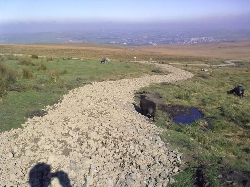 [/IMG]
Windy as hell up there yesterday! There were also hundreds of birds going totally nuts just at the side of the link, not sure if they were enjoying the thermals or were peed off at the appearance of the link. It was like being in a Hitchcock film! 😯
the hardcore has been laid since I was up there last..
Can't wait to give it a try and actually get to Lee Quarry for the first time! :-/
Elspaniel - Thanks, useful information! Saw the Air Ambulance up at Cowm on Saturday, think it was landing in the other quarry though.
I will be up there on duty (I'm one of the volunteer rangers) on sunday (from about 10 - 3either in lee or cragg)if anyone has any questions or needs directions please feel free to find me and I will do my best to answer them or show people round g
heres a video of the helicopter today
wicked being that close to it. The sound from it was amazing
check out the video of the chopper brilliant!
What is the link like now? Off there tomorrow hopefully.
Not open yet I don't think.
