- This topic has 19 replies, 11 voices, and was last updated 7 years ago by bigjim.
-
GIS Qualifications
-
muckerFull MemberPosted 7 years ago
My employer, a local authority, has offered to support up to four individuals in undertaking further education to gain qualifications which will be of benefit to the organisation.
I believe we lack people who are able to use GIS and are suffering because of this.
Is there anyway to gain a useful qualification in this subject for someone without a degree (I have an HND in forestry).munrobikerFree MemberPosted 7 years agoIf you get in touch with ESRI they are doing a six week course, which I believe is free, for ArcGIS. I’m hoping to do it myself.
jam-boFull MemberPosted 7 years agoCourses on how to operate GIS or the principles behind GIS?
I did a distance learning masters with UNIGIS about ten years ago. Lots of theory, got bored of it, took a pgcert and have barely used a GIS since.
JEngledowFree MemberPosted 7 years agoDo you have an existing GIS system which you want to be able to get more value out of? If so your best bet may be to get some specific training on that software. Try contacting the software company and ask if they offer any training.
technicallyineptFree MemberPosted 7 years agoWe have loads of GIS users at work. Most just gained experience using it as part of their undergrad degrees (something geography related).
Surely what you need is a comprehensive introduction to the GIS software your organisation uses.
Doing anything really useful with the software will likely require some programming aptitude.
DavidBFree MemberPosted 7 years agoGet on a QGIS course. Then work hard to get your LA to bin ESRI and save us tax payers a fortune.
bigjimFull MemberPosted 7 years agoYeah ESRI do various training courses and the first one I did was full of local authority staff. Check your organisation uses ESRI software first though. Otherwise depending where you are there are a variety of training courses etc offered
soma_richFree MemberPosted 7 years agoGet on a QGIS course. Then work hard to get your LA to bin ESRI and save us tax payers a fortune.
Very much this! I wouldn’t be surprised if you can do everything your LA need in QGIS.
ebygommFree MemberPosted 7 years agoQualifications or training?
Specific software training is likely to be more useful than a generic GIS qualification.
mikey74Free MemberPosted 7 years agoAs a slight hijack: I’m now on summer break from my Geology course and was thinking of using the spare time to learn some geology-related GIS. Any tips?
LucasFree MemberPosted 7 years agoIf you have arcmap download BGS.sigma mobile and map some rocks. Its a customised interface to arc which links to dedicated database forms to record everything in a structured and consistent manner
mikey74Free MemberPosted 7 years agoHowever:
– ArcGIS do a personal use license for $100.
– QGIS is free.Is ArcGIS worth spending out on?
Are there any good, free tutorials out there for a GIS beginner (albeit an Architecural technician who’s been using CAD/Revit packages for a long time)?
LucasFree MemberPosted 7 years agoIf you want to learn the basics of gis then go for the qgis, no point spending money on arc just to learn about gis.
If you have cad experience then maybe think about geological modelling, make 3d models of geological formations etc. Go and do some mapping, record the dips etc then make a model of what you think is going on.
Gis was used to make the digital maps, but is increasingly used to mash up data and produce products focused on and taylored to a user. The output of a mapping project is now an attributed 3d model
footflapsFull MemberPosted 7 years agoI’ve thought about doing a GIS Masters, ended up writing loads of GIS related SW for work without any background in the subject. Still don’t really get what a Projection is…..
As for ArcGIS, if there was an award for inefficient file formats, it would win by a mile. Using 64 bit IEEE number format for GeoTIFFs of Lidar data. 3/4 of my HD used space is full of 0s.
jam-boFull MemberPosted 7 years agoIf you want to learn the basics of gis then go for the qgis, no point spending money on arc just to learn about gis.
downloaded QGIS recently as I had to knock up a location map for a presentation. Looks remarkably like ArcGIS 8.3 did when I stopped using GIS.
re projections. – try fitting a flat sheet of paper to a globe…
bigjimFull MemberPosted 7 years agoI wouldn’t be surprised if you can do everything your LA need in QGIS.
Yeah it’s a funny one, my current public sector employer is locked into an ESRI Enterprise agreement and it’s incredibly frustrating, we’re not allowed to use anything non ESRI. ESRI is the ‘industry standard’ but if it’s all you can use it’s quite limiting for many reasons. I think there’s a bit of a push to get things more open in the public sector which is good.
Still don’t really get what a Projection is…..
Dont’ worry neither to 75% of GIS professionals! There have been some spectacularly expensive cock ups from people getting projections wrong and things getting built in the wrong place. Once you get into them though it’s kind of satisfying in the same kind of way as pulling your nose hairs out.
As for ArcGIS, if there was an award for inefficient file formats, it would win by a mile.
Everything ESRI is bloated and inefficient is my conclusion from ten years of daily use. But their founder is one of the richest people on earth now so it doesn’t seem to have caused them many problems.
footflapsFull MemberPosted 7 years agoDont’ worry neither to 75% of GIS professionals! There have been some spectacularly expensive cock ups from people getting projections wrong and things getting built in the wrong place.
I just convert everything I’m doing into KML and double check in Google Earth that it’s where I think it should be, which is OK for the resolution I work at….
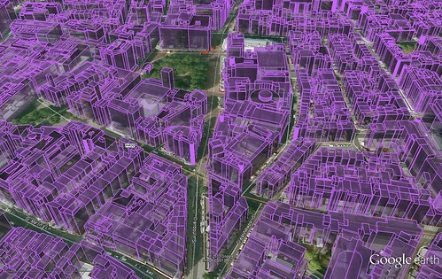
Quite handy as a double check, eg in this file (bought map) I found that they’d miss-coded the Hilton Hotel (nr Green Park) at 30m rather than 110m AGL….
 [url=https://flic.kr/p/e8711P]3D London Building Height Data (DEM) converted to KML file[/url] by Ben Freeman, on Flickr
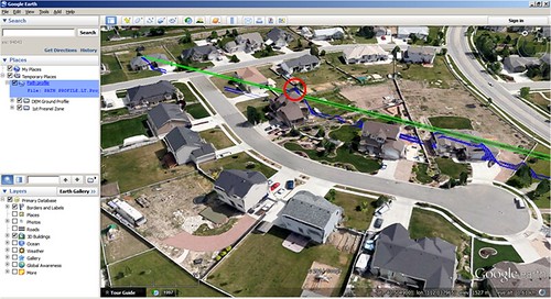
Radio Line of Sight stuff. Green is Fresnel Zone, Blue is bloated Lidar data from ArcGIS….
[url=https://flic.kr/p/opGpuP]Path Profile and Fresnel zone in Google Earth KML[/url] by Ben Freeman, on FlickrmunrobikerFree MemberPosted 7 years agomikey74 – If you’re at Uni then you uni should have free access to Arc’s online software (if that’s what your Uni use, ask them about it).
I did an Environmental Geology degree and my dissertation was GIS heavy as I did a lot of geophysics – see if your department has a Geonics EM38 (or similar) you can borrow, potter about something that you can geophys (usually farmer’s fields or old landfill sites, check the EA “What’s in Your Backyard” for your local abandoned landfill…) and then GIS it into something fun.
bigjimFull MemberPosted 7 years agoI just convert everything I’m doing into KML and double check in Google Earth that it’s where I think it should be, which is OK for the resolution I work at….
As punishment you need to read the bible: http://www.iogp.org/Geomatics

The topic ‘GIS Qualifications’ is closed to new replies.