Where exactly in Guildford does the route start? Since it's along a disused railway then presumably it must start somewhere neat the rail station.
Any good pubs on the route to Shoreham?
Downs Link actually starts due east at Martha's Hill. Can follow the Pilgrim's Way to it or follow the Wey South Path, (south) alongside the river to black footbridge going over the river, near Peasmarsh and go left. Downs Link starts over the A281 - where it is all flat and easy going (Martha Hill section to Bramley has rougher and steeper trails).
Choice of pubs etc in Cranleigh and Southwater or the pub in Partridge Green looked ok.
From Guildford, pick it up outside Shalford, opposite junction of Horsham Rd and Trunley Heath Rd. Dead easy from there on. Not done the initial Marthas Hill section, pretty sandy and slow going from what I've been told.
I've ridden at all the way to Shoreham. Apart from a bit near Guildford it's VERY flat!
you can access downslink by riding along the canal south till you get to broadford road bridge - cross over that, then turn right (south) onto horsham road, and then left onto downslink just after you cross the canal.
several ex railway stations on the way which offer nice pubbage.
Its my (occasional) off road route home to brighton.
yes, it is rather dull. Essentially it's a railway line, so very straight. and flat, you even miss the south downs if you're heading to shoreham.
It's boring. Also, the gradient runs steadily "up" from Guildford. Don't do it, trust me, you'd rather watch paint dry.
Ironically, it was the first "day" ride I and a couple of pals did back in 1992 just after we'd got our first "all terrain" bikes. Afterwards, we thought we'd become right proper mountain bikers.
Little did we know...
It's not a mountain bike ride - you can do it on a cross bike, no problem. Average speed is high because it's flat (apart from the small hill at Rudgwick that the line went through but you have to go over) and it's worth doing for the views and a few points of interest along the way. We parked at Guildford station, rode the canal (right bank towards Godalming) then the railway line to Shoreham and the road then cycle paths along Hove and Brighton seafronts to get to Brighton station.
Maps/route guides are [url= http://www.westsussex.gov.uk/ccm/content/your-council/departments-and-services/environment-and-development-services/publications-list/14-tourism-leisure-walking-and-cycling.en ]here[/url].
There's a pub [url= http://www.multimap.com/s/hxXqI93R ]here[/url], called the Bax Castle, that's almost exactly halfway and good for lunch.
Also, the gradient runs steadily "up" from Guildford.
No it doesn't, it ends basically at sea level, so the prevailing gradient is down hill, it's not really noticeable anyway!
As others have said, it's not a mountain bike ride by any stretch, it gets very busy too in summer. I quite like it as an alternative to a road ride every now and then, mindless! I live right on it, Shoreham and back is 65 miles, nice ride.
I was thinking of doing this in a couple of weeks' time.
Can anyone offer a slightly more interesting option, still ending at Shoreham?
I've only done it once and I will never forget it! I started the day on an early train to Winchester and rode the South Downs Way to Shoreham, with a few friends joining me at Harting Down. It was a stunning day, almost nostalgic, one of those where you feel like you’re in a Mint Sauce cartoon: bright blue sky, bright yellow rape seed, bright white chalk and bright green everywhere else.
Finishing the ride on the Downs Link had been on my mind, I was ramping up for MM solo and I lived in Guildford at the time, so it felt like a satisfying way to finish the loop. When we passed the Downs Link sign to Guildford outside Shoreham, I decided I was fresh enough to do it, but I’d be doing it for the sake of it, the riding wouldn’t be that great (level, gravelly track, slightly uphill all the way to G’ford) and that I’d rather relax with the others in a pub in Shoreham.
Dinner and a few pints later, the others realised they had to leave right that second to catch a decent train back to London. Through a beery fug, I decided that I did fancy the Downs Link ride after all, and that I’d like to enjoy the rest of my beer and the sunset at my own pace.
I left after the sun had set. I was going to take it easy, but the beer got the better of me and I started to really enjoy spanking along and feeling the burn. I’d been going a fair while when I saw a map of the route at the side of the path. “I must be well past half way, I’ve really broken the back of this!” I thought, as I swaggered up to the map. I’d done less than a third. I crashed completely. Utterly demoralised and suddenly absolutely knackered.
Back on the bike, a lot slower this time. Properly dark now, and deep in the railway cuttings with the trees meeting above the path, it was very dark indeed. I only had a little commuter light with me, which did that trick of making everything look darker without giving any useful light in front of the wheel. Where the path jogged left and right across the roads, I had to ride up and down the road to find the signs and take the front light off to inspect them close up and make sure I was following the right ones. I was finding it hard to stomach any more bloody raisins or bloody cashew nuts and I had to keep stopping for little naps on benches and patches of grass.
My average speed was so slow that I bailed on the Link path after Cranleigh and took the road back to Guildford. A couple more naps and some very weary cycling later, I made it back to Guildford, cycled through town watching people who’d had a very different Saturday night, had quick shower and crumpled into bed at 2 in the morning.
Urg.
njee20 - MemberAlso, the gradient runs steadily "up" from Guildford.
No it doesn't, it ends basically at sea level, so the prevailing gradient is down hill, it's not really noticeable anyway!
Yes it does. Yes it is.
It's very basic geography, according to my GPS I'm sat in my office in Guildford at 200ft above sea level, the end at Shoreham is about 8 feet above sea level.
The overall prevailing gradient is down hill.
There are some draggy sections in both directions, the A281 after Rudgwick to Slinfold is particularly bad, the gradient does not make it noticeably harder in either direction.
I live right by it in Shalford. It's OK for getting to Cranleigh for a quick buzz on the bike. By the time I get to Cranleigh though I'm mindnumb from the boredom. I'd rather stab myself in the eyes than go all the way to Shoreham.
I'm gonna put that into practice! Let's ride to Shoreham on Saturday...
I'd rather stab myself in the eyes than go all the way to Shoreham.
That's why it took me 3 1/2 pints to start thinking it was a good idea. If I'd ridden any of it before, it might have taken a lot more!
There are some draggy sections in both directions, the A281 after Rudgwick to Slinfold is particularly bad, the gradient does not make it noticeably harder in either direction.
Yes it does.
Nothing to add except avoid the Martha's Hill start- very sandy and at this time of year dry enough to make pedalling downhill hard work.
It is slightly down north to south. Me and a mate used to ride from Southwater to Shoreham and back on a week day eve, when we first started riding ATB's! Definately a slight gradient on the return.
It is boring, and I've not ridden it for many many years - still, best to have it there than not.
You could come off it at Steyning/Bramber and loop round on the downs, but you're almost at Shoreham by then....
Yes it does.
Over the whole ride I really don't think it does, and I've done it a lot!
If I may. This includes St Marthas:
[img] 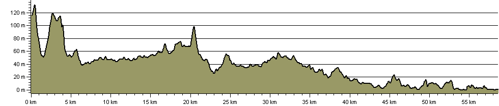 [/img]
Still reckon the ruling gradient is up from Guildford!? The wind is a different story mind, you do often get a southerly wind, making the return journey easier.
That's definitely up hill.
You can prove anything with a chart!
Meh, the graph really just supports the facts after all, it's very basic geography:
Guildford: not at sea level
Shoreham: at sea level
In order for it to be an uphill prevailing gradient going South there would have to be some interesting physics going on! 🙂
Some bits of the DL would be excellent for bike jousting. Nice and straight, plenty of run up. Maybe this could be settled that way?
Well. We did it both ways. Perhaps I'm confusing "gradient" with "knackered"...
Mr Woppit now you've seen a picture and believe it this is for you
[img]  [/img]
It's uphill from Bramley to Rudgwick where there used to be a tunnel, now closed, before descending almost all the way (there are a couple of small hills whenever you leave the course of the original railway line) to Shoreham. I know this because I ran the 22 miles from Horsham to Godalming along it with a mate on a bike as support. Going from Cranleigh to Bramley I was so knackered that I was convinced we were going uphill. My mate rolling alongside, not pedalling, said otherwise.
The hill up to Rudgwick from the Horsham side was going to be so steep that the local landowner refused to let the railway company build on his land until they lessened the gradient (trains didn't have braked carriages then and runaway trains were common). They had already built the line approaching his land including a bridge over a river so had to double the embankments and build another bridge on top of the original.
[img]  [/img]
As others have said, it's an absolute piece of pi55. I used to live near the middle of it so often included various sections in my evening blasts.
Nice and chilled up near the River Wey, then pretty dull until you reach West Grinstead when the scenery suddenly opens up.
As for pubs, I used to drink in the Bax Castle (nr Christ's Hospital) and The Bridge (Copsale). The former used to be half decent for pub grub, whereas the latter was far better for lock-ins (we used to have fry-ups at 1:00-2:00am 😀 )
I grew up just outside Rudgwick and used to use the link all the time. The hill just north of Rudgwick goes over a tunnel (banards Tunnel) that you have to go to the left of and over (not directly over, there's a left/right turn at the top which heads you down towards where the banards station used to be (a pub I used to frequent called the Thurlow Arms)
I believe that the tunnel is protected (and locked up) as it homes a lot of bats.
It may be a bit flat and boring, but it's more interesting and direct than the road.
avdave2 - Member
Mr Woppit now you've seen a picture and believe it this is for you
Not really. Clearly your attention to detail is as poor as your analytical skills.
Do you know what the word
means?Perhaps
Well if you are going to ride it please be quite as the sound of bike wheels swishing over gravel through Bramley disturbs me in my back garden
*does skids outside NIG E5's house*
In your case Mr Woppit "perhaps" seems to be the closest you can get to saying "Sorry njee20 you were right and I was wrong."
Go on I dare you to put that in writing. 🙂
As everyone has said, it's really boring. Don't bother, unless you're trying to 'get the miles in' on the way to a few hills. Best advice if you're going to do it would be to ride it fast until you hit the section where it crosses the South Dwons way and then get up there and do a few miles along to Ditchling Beacon or furhter and then when you're bored of the South Downs Way (it's a bit boring too I'm afraid) you can head back and down into Shoreham.
+1 for Bax Castle as a decent pub too
avdave2 - Member
In your case Mr Woppit "perhaps" seems to be the closest you can get to saying "Sorry njee20 you were right and I was wrong."Go on I dare you to put that in writing.
Oh.
a pub I used to frequent called the Thurlow Arms
Good pub, closed about 3 years ago after the landlord died.
I would suggest you are confusing the two though, I must have done it 30 times in each direction over the years.
Shoreham: at sea level
You mean Shoreham-by-Sea to give it, it's proper name. What makes you think it's at sea level?
Anyway, Shoreham isn't all at sea level.
You'd get your socks wet in Smiths.
Well I did originally say that the end was 'about 8 feet above sea level' to appease the pedants! The point is that it's lower than Guildford.
If you have the time and inclination to look over a map, there are quite a few xc bridleway loops you can access, leaving and rejoining the Downs Link to connect them together without using the main road. That's how I use it.
As mentioned earlier, from Guildford station you can use the Wey towpath to reach it. But you don't need to turn off at Broadford Road as a couple of years ago the route was extended on the other side of the A281, including a bridge over the Navigation which you can access directly from the towpath.
Did the Downs Link for the first time yesterday on a nice ride from Denbies (Dorking), up on to the NDW, down at Newlands to just east of St Marthas, Downs link through to SDW and then SDW to Devils Dyke. Lovely day, lovely fast ride of just under 50miles. Lots of potential stops if you're taking a more leisurely approach as well.
Although I read this thread before doing it and expected to agree with njee, I have to say I do agree
with Mr Woppit 😯 😉
...there's a lot of long straight stretches where, on balance, the gradient is up for the majority of the way. Only mildly and it's still big ring all the way but there's not much opportunity to freewheel down.
AFAIK the Bridge at Copsale is closed.
I spent years living close to it, so have fond memories of it. A nice little warm up from where I lived in Henfield to the South Downs at Steyning.
Riding it is a great way to introduce those with gradiant-phobia to off-roading.
The Bridge is very definitely closed - it has no rear walls.
