- This topic has 45 replies, 16 voices, and was last updated 10 years ago by ninfan.
-
Blanchland – Hexhamshire Common
-
salsaFree MemberPosted 10 years ago
Hi
Can anyone tell me is the track running from Baybridge, Blanchland through Beldon Shields and Riddlehamhope to harwood Shields a right of way for bikes, the section at Harwood Shields is but was wondering about the other bits of track?
Also the track running from Spartylea through Ladle Well to Burnt Ridge is there a right of way for bikes on this?
Thanks
user-removedFree MemberPosted 10 years agoI just get on and cycle wherever I like ( also in north east England but from Scotland, where everyone just rides wherever they like ).
bajsyckelFull MemberPosted 10 years agoNot on either. Former is a footpath, latter is accessible (on foot) under CROW. Both sometimes get used on trailquests/ adventure race type events. The estate are arsey about bikes on the track out of baybridge and it runs right past the keeper’s place so probably best to be smart about trying it on. The second one is very good quality estate track and IMO infinitely more sensible than trashing the bridleways in the wet (not that I’d condone that sort of thing you understand).
Edit – as tracks that do get used for events occasionally I’d not try to use them if I thought it might be antagonistic to do so.
salsaFree MemberPosted 10 years agoThanks for that Bajsyckel, I’ll stay off them, was looking at options to link up Blanchland to Allenheads
bajsyckelFull MemberPosted 10 years agoIt’s a shame about the baybridge one – IIRC there was an application for bridleway status which was rejected in the high court. It’s a mix of landrover and grassy track, well draining and would make a perfect and sustainable link for bikes and horses. After riddlehamhope (a massive ruined shooting lodge) it meets bridleways and more estate tracks which link onto Allendale’s land including the second track you describe above and another which runs all the way to the Durham/ N’land border above Allenheads. Nowadays the estate tracks up there (double track) are very fast and useful if conditions were to close in, and out of shooting/ nesting season you’d be unlikely to disturb anyone.
Obvious alternatives are to take the bridleway (now byway) north to S. forest then west to drop down to cross the Devil’s Water, then pick up a bridleway over to allendale. There are well-surfaced options but most others (in particular Broadway) are less direct and can be pretty bad condition/ easily damaged unless it freezes or in summer conditions. Alternatively going south and after a little road climb, you could pick up either the sustrans C2C or the mining route (byway/footpath depending on the sign at either end) leading over Bolts Law. This is great fun in reverse other than a wee boggy stretch on the West side. That leaves you with a bit of road (a drag, windy but nice road) between Rookhope and allenheads though.
user-removedFree MemberPosted 10 years agoGood info, ta. Some great riding to be had up that way. Still stand by my original comment though – I literally do just ride wherever I fancy. Been caught a few times and had to turn round but that’s the worst that can happen.
Generally, it doesn’t cross my mind that I shouldn’t cycle somewhere. I do avoid anything marked, “Danger Area” on the map though.
salsaFree MemberPosted 10 years agoMany thanks for the info, may see you up there, I only live 20 miles away but never ridden there until last weekend, looks a great area.
ninfanFree MemberPosted 10 years agoThe whole treatment of the Carriers way and surrounding/feeding routes has been a travesty over the years, with years spent arguing over ridiculous levels of detail, such as the status of the 1727 mining lease between the London Lead Company and the Late Bishop of Durhams estate… with no focus by any of the three sides on the actual routes on the ground, which everyone accepts where old pack horse roads, or the powers of the council to create rights of way that even they accept would be beneficial. Bloody joke!
I did the riddlehamhope to bay bridge road many years ago, with an argument over the legal status of walking on a footpath with bicycles en route – and it was a lovely route. I believe that case turned many years ago on whether the milestones would have been for public or private use!
salsaFree MemberPosted 10 years agoI did notice there seems to be lot of bridle ways suddenly turning into footpaths across the area. I assume with the mines in the area every track would be a pack horse track at some point or other.
paulrockliffeFree MemberPosted 10 years agoI’ve been renovating a house this year just a few miles East of Blanchland, not had much time for riding but hopefully that’ll change. Didn’t know there was a load of bridleway up that way, so that’s good.
The whole area seems a bit unusual in that there’s footpaths everywhere, but hardly any bridleways. Is there much in Slaley Forest do you know?
ninfanFree MemberPosted 10 years agoIts tough – firstly you need to look at the ‘big picture’ – most of these routes were pack horse routes heading from the mines and later the smelting mill at Whitley Chapel through to, roughly, Hedley on the Hill, and then the Lead Road through Greenside down to Blaydon. Further south you’d be looking at the routes to the smelting mill at Rookhope and then towards Leadgate and on to town.
If you look as those being the main fingers, you can see the orientation of most of the old pack horse roads, and why they would be going there – throw in of course the routes to market towns and you’ve got most of the current rights of way – and you can also see which are blatantly misrecorded at footpaths, just from the natural orientation and continuation of the pack horse routes.
Problem is how many of these routes were ‘public’ and how many were by permission of the mining lease – thing is it seems that even these old routes have been accepted as having a ‘right’ on foot, but with no historical ‘right’ to lead a horse, which just doesn’t seem to add up really 😕
paulrockliffeFree MemberPosted 10 years agoWhat’s the riding like up there generally?
I’ve done one ride out of Hexham that was supposed to be good, but I remember it being a grassy slog up and a grassy slog down. Looking at my maps I went over Eshells Moor and Greenrigg Moor. West Dipton Wood was OK, but a bit spooky!
I’m right next to what becomes the Waskerly Way, so can get up to Blanchland pretty much all off road from my door, so it would be great if there was good stuff up there!
butcherFull MemberPosted 10 years agoThe whole area seems a bit unusual in that there’s footpaths everywhere, but hardly any bridleways. Is there much in Slaley Forest do you know?
Not a lot in the forest itself. But the classic Edmundbyers – Bolts Law Route meets the forest. You do have access to loads of routes from there.
Still stand by my original comment though – I literally do just ride wherever I fancy.
The Baybridge route has the biggest no cycling signs I’ve ever seen. I would normally just sneak through – and have done that route once – but they make you feel very unwelcome.
butcherFull MemberPosted 10 years agoThe Bolt’s Law route is one of the better known ones. MBR featured it (there’s a map online somewhere), and MBUK featured it with Guy Martin too!
Bolt’s Law itself is a couple of miles from the top of Waskerley, if you follow the quiet country lane along meadows edge (heading towards Blanchland). On your left you’ll see a trig point on the top of the hill (I think…my memory is bad….there’s a mound of stones, definitely…you’ll see something on top of the hill!) That’s it. There’s a good route up from Edmundbyers, which is usually the starting point, but if you only do it one way, head down towards Edmundbyers.
The full route goes all the way up to Slaley and takes in the moors at Blanchland, before heading up towards Rookhope, but then cuts off onto the moor and approaches Bolt’s Law from behind (though it’ll probably be easier to swim that particular bit at this time of year).
paul4stonesFull MemberPosted 10 years agoI’ve got onto the baybridge track by going over the hill from the carriers way having come onto it from slaley end. There’s often nobody about but that depends on the season. Riddlehamhope is an eerie place.
The Sparty Lea track is known as the drag by participants in the Allendale challenge – with good reason! It’s probably not a bad thing that you’re not allowed on there to go up at least.Further north, round Otterburn and the N Tyne valley, there are some paths marked as bridleways and vice versa. Apparently they just drew the maps from satellite images and guessed the status. Some bridleways are completely inaccessible by horses with stiles and squeezer gaps in walls, etc.
gazcFree MemberPosted 10 years agopaulrockliffe – funnily enough we’re doing a house up to move out that way too and we’ll be right on the derwent walk 😆 i know a couple of routes heading up towards bolts law but not actually done a ride including it. got a few things on with house/baby at present but would be up for heading up that way in a few weeks – give us a mail if you fancy joining up to do it as i need to explore the area a bit more in general too, as i’ve mostly done riding closer to town
have done a bit of riding in slaley forest but from memory it was a pure bog fest. the rocky singletrack down embley fell was a better descent at the time
esselgruntfuttockFree MemberPosted 10 years agoWish you lot would shut up! I started my biking around there 24 years ago & would often go from Baybridge to Riddlehamhope/Harwood Shield/Viewley & back up Embley Fell. We even used to do a loop from Whitley Chapel to Ladle Well/Sinderhope Carrs/Spartylea &….some other places I can’t remember!
Must go back this year!mahul1999Free MemberPosted 10 years agoSome good routes for the area here :
The edmundbyers route can be extended by heading down the bolts laws bridle way , it’s a great bit of singletrack but probably needs a bit of dry weather to be fully enjoyed .
mahul1999Free MemberPosted 10 years agoThink I did that link wrong , search ‘beyond hamsterley’ on amazon
paulrockliffeFree MemberPosted 10 years agoBolt’s Law is surrounded by footpaths according to my OS Map?
Gazc – Where abouts are you at? I’m down in Lanchester, I think the Derwent Walk meets the C2C at the Hownsgill Viaduct by the looks of it.
Would be good to meet up one weekend for an explore, I’ve got a few more weekends of breaking the back of our place, but once the carpets are in I’ll have a bit more freedom at weekends. I work in Manchester, so it’s not ideal at the moment, but hopefully that’ll change soon.
The whole area needs a good explore as I could do with finding a decent quick blast loop from home as Edmundbyers and back is a 30 mile ride before getting into any of the trails mentioned. I’m sure there’s a cheeky loop going somewhere, just need to find it.
butcherFull MemberPosted 10 years agoThere’s one Bridleway which passes over Bolt’s Law. All the rest are footpaths. And the off-road c2c route which passes close by.
Here’s the full route and MBR article (I hope the mods don’t mind. And I was obviously incorrect when I said this was in MBUK!)
http://www.mbr.co.uk/news/feature-riding-with-tt-ace-guy-martin/
Loads of road riding round your way Paul. But Bridleways a bit thin on the ground. Cheeky trails are the way forward.
hot_fiatFull MemberPosted 10 years agoWas up that way a couple of weekends ago. It’s just a tad boggy at present and I wouldn’t recommend it until we get either a very thick frost or much drier weather.
Northumberland council have the definitive map online. It’s a bit clunky but will show you exactly which paths are accessible by what.
paulrockliffeFree MemberPosted 10 years agoThanks, that’s a great couple of links. Wonder why the OS map shows no bridleways there?
I know the roads are great, I’m surrounded by short to medium steep hills on very quiet roads, with long steep hills in the wilderness a few miles away.
When I’ve got more time I’ll start checking out various cheeky options and put together some routes hopefully. I think I probably need a cyclocross bike, it’s 16 miles to Hamsterley and similar to Edmundbyers, which might be doable with a new bike.
paulrockliffeFree MemberPosted 10 years agoThat definitive map doesn’t look right. There’s loads of footpaths marked on the OS Map that aren’t on there and half the bridleways out of Edmundbuyers and Blanchland appear to be missing too?
bajsyckelFull MemberPosted 10 years agoNot meaning to point out the obvious, but they’re in Durham, innit.
paulrockliffeFree MemberPosted 10 years agoThat’s true, good point. I assumed they were covered as they showed the OS map for those areas, but not for others, but I guess it’s a function of the size of the tiles that OS throw up.
ti_pin_manFree MemberPosted 10 years agoLived in Allendale in the 90’s and know the area pretty well. the baybridge route mentioned wont make you popular with the local landowners, the large house is/was owned by somebody who might fly in to shoot grouse, so his staff arent best pleased to see bikers on anything other than the BW’s. I’ve ridden them a few times on my own and used them to link other BW up down to Blanchland but on a couple of occasions run into ‘blokes in 4×4’s’ -gerrrr ooff myyy land.
so go in stealth mode or avoid.
EDIT: does anybody know if Riddlehamhope was ever bought by anybody and done up? marvellous spot.
paulrockliffeFree MemberPosted 10 years agoSounds exciting, I’ll get my best ninja suit out and avoid any daylight if I venture up that way!
paul4stonesFull MemberPosted 10 years agoEDIT: does anybody know if Riddlehamhope was ever bought by anybody and done up? marvellous spot
Wasn’t in 2011.
 ti_pin_manFree MemberPosted 10 years ago
four of us had a cheeky look around on the inside 15/20 years ago, it was fascinating, would be a great place and if it came up for sale I’d be interested. talk about bleak and remote, perfecto. 😀 now I want to come biking back in northumberland… arrgghh.
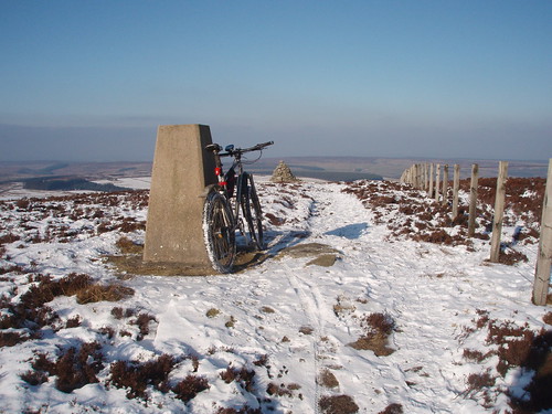
ir_banditoFree MemberPosted 10 years agoBolts Law last winter:

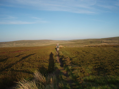
Hexhamshire Common, this summer:
There’s a lot of work being done locally to get old bridleways reinstated. But some of them are hard to do.
Most of the cheeky riding locally is fine, except on the moors where the landowners get pissed off that you might hurt the baby birds before they can be shot.
ninfanFree MemberPosted 10 years agoit was fascinating, would be a great place
Its been on my ‘If I won the lottery’ list for years 😕
The view down the valley from one of the upstairs bedrooms was just amazing
butcherFull MemberPosted 10 years agoThat definitive map doesn’t look right. There’s loads of footpaths marked on the OS Map that aren’t on there and half the bridleways out of Edmundbuyers and Blanchland appear to be missing too?
Not looked on the definitive map, but it’s on every other map I’ve looked at.
You can see it on the OS view on Bing Maps here http://binged.it/1ejtqNG
it was fascinating, would be a great place
Riddlehamhope is awesome. But a real horror movie location. Not sure I’d want to live there.
gazcFree MemberPosted 10 years agopaul – i’m in Ebchester, and yeah it joins just before the viaduct where the steel crucible monument thing is, so we’re about equidistant to Edmundbuyers via the cycle paths. currently trying to decorate the house but taking longer than i expected with a baby… 😯 so i’ll be up for heading out in a few weekends time too, probably late feb/early march. i’ll send you a mail and can arrange to meet at the junction if you like? cheers
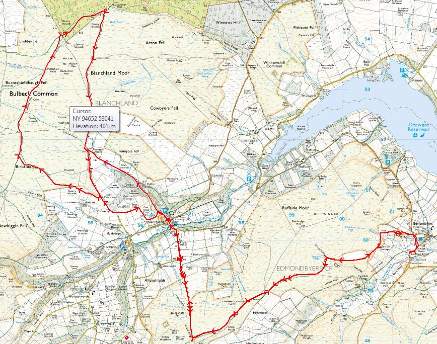
P20Full MemberPosted 10 years ago
Edmunbyers & Blanchland by ritcheyp20, on FlickrBolts law is the other side of the road (west) of the Edmunbyers track.


The topic ‘Blanchland – Hexhamshire Common’ is closed to new replies.